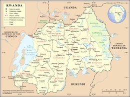
Geography of Rwanda
Rwanda is located in central Africa, to the east of the Democratic Republic of the Congo, at the co-ordinates 2°00′S 30°0′E.
 | |
| Continent | Africa[1] |
|---|---|
| Region | East Africa |
| Coordinates | 2°00′S 30°0′E |
| Area | Ranked 144th |
| • Total | 26,338 km2 (10,169 sq mi) |
| • Land | 97% |
| • Water | 3% |
| Coastline | 0 km (0 mi) |
| Borders | 893 km (DRC 217 km, Burundi 290 km, Tanzania 217 km, Uganda 169 km) |
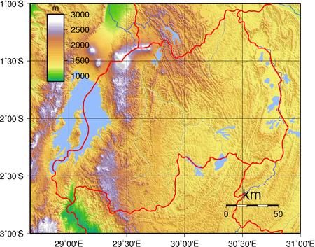
| Highest point | Mount Karisimbi 4507 m |
| Lowest point | Rusizi River 950 m |
| Longest river | Nyabarongo |
| Largest lake | Lake Kivu
 Satellite image of Rwanda |
At 26,338 square kilometres (10,169 sq mi), Rwanda is the world's 149th-largest country.[2] It is comparable in size to Haiti or the state of Massachusetts in the United States.[3][4] The entire country is at a high altitude: the lowest point is the Rusizi River at 950 metres (3,117 ft) above sea level.[3]
Rwanda is located in Central/Eastern Africa, and is bordered by the Democratic Republic of the Congo to the west, Uganda to the north, Tanzania to the east, and Burundi to the south.[3] It lies a few degrees south of the equator and is landlocked.[5] The capital, Kigali, is located near the centre of Rwanda.[6]
Major geographic features
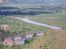
The watershed between the major Congo and Nile drainage basins runs from north to south through Rwanda, with around 80 percent of the country's area draining into the Nile and 20 percent into the Congo via the Rusizi River.[7] The country's longest river is the Nyabarongo, which rises in the south-west, flows north, east, and southeast before merging with the Akanyaru to form the Akagera; the Akagera then flows due north along the eastern border with Tanzania. The Nyabarongo-Akagera eventually drains into Lake Victoria, and its source in Nyungwe Forest is a contender for the as-yet undetermined overall source of the Nile.[8]
Rwanda has many lakes, the largest being Lake Kivu. This lake occupies the floor of the Albertine Rift along most of the length of Rwanda's western border, and with a maximum depth of 480 metres (1,575 ft),[9] it is one of the twenty deepest lakes in the world.[10] Other sizeable lakes include Burera, Ruhondo, Muhazi, Rweru, and Ihema, the last being the largest of a string of lakes in the eastern plains of Akagera National Park.[11]
Mountains dominate central and western Rwanda. These mountains are part of the Albertine Rift Mountains that flank the Albertine branch of the East African Rift. This branch runs from north to south along Rwanda's western border.[12] The highest peaks are found in the Virunga volcano chain in the northwest; this includes Mount Karisimbi, Rwanda's highest point, at 4,507 metres (14,787 ft).[13]
This western section of Rwanda, which lies within the Albertine Rift montane forests ecoregion,[12] has an elevation of 1,500 metres (4,921 ft) to 2,500 metres (8,202 ft).[14] The centre of the country is predominantly rolling hills, while the eastern border region consists of savanna, plains and swamps.[15]
Rwanda has a temperate tropical highland climate, with lower temperatures than are typical for equatorial countries due to its high elevation.[5] Kigali, in the centre of the country, has a typical daily temperature range between 12 °C (54 °F) and 27 °C (81 °F), with little variation through the year.[16] There are some temperature variations across the country; the mountainous west and north are generally cooler than the lower-lying east.[17]
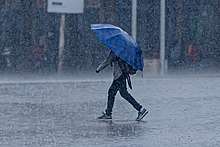
There are two rainy seasons in the year. The first runs from February to June and the second from September to December. These are separated by two dry seasons: the major one from June to September, during which there is often no rain at all, and a shorter and less severe one from December to February.[18] Rainfall varies geographically, with the west and northwest of the country receiving more precipitation annually than the east and southeast.[19]
Political geography
Rwanda borders Burundi for 290 km, the Democratic Republic of the Congo for 217 km, Tanzania for 217 km, and Uganda for 169 km.
Physical geography
Rwanda has an area of 26 thousands square kilometers, of which 3 percent is water.
Climate data
| Climate data for Kigali, Rwanda | |||||||||||||
|---|---|---|---|---|---|---|---|---|---|---|---|---|---|
| Month | Jan | Feb | Mar | Apr | May | Jun | Jul | Aug | Sep | Oct | Nov | Dec | Year |
| Average high °C (°F) | 26.9 (80.4) |
27.4 (81.3) |
26.9 (80.4) |
26.2 (79.2) |
25.9 (78.6) |
26.4 (79.5) |
27.1 (80.8) |
28.0 (82.4) |
28.2 (82.8) |
27.2 (81.0) |
26.1 (79.0) |
26.4 (79.5) |
26.9 (80.4) |
| Average low °C (°F) | 15.6 (60.1) |
15.8 (60.4) |
15.7 (60.3) |
16.1 (61.0) |
16.2 (61.2) |
15.3 (59.5) |
15.0 (59.0) |
16.0 (60.8) |
16.0 (60.8) |
15.9 (60.6) |
15.5 (59.9) |
15.6 (60.1) |
15.7 (60.3) |
| Average precipitation mm (inches) | 76.9 (3.03) |
91.0 (3.58) |
114.2 (4.50) |
154.2 (6.07) |
88.1 (3.47) |
18.6 (0.73) |
11.4 (0.45) |
31.1 (1.22) |
69.6 (2.74) |
105.7 (4.16) |
112.7 (4.44) |
77.4 (3.05) |
950.9 (37.44) |
| Average precipitation days (≥ 0.1 mm) | 11 | 11 | 15 | 18 | 13 | 2 | 1 | 4 | 10 | 17 | 17 | 14 | 133 |
| Source: World Meteorological Organization[20] | |||||||||||||
Natural resources
Rwanda possesses the following natural resources:
- gold
- cassiterite (tin ore)
- wolframite (tungsten ore)
- columbite-tantalite (tantalum and niobium ore)
- methane
- hydropower
- coffee
- tea
- arable land
- green beans
The use of land in Rwanda is largely for arable land, and other purposes. 40 km² of land in Rwanda is irrigated. The table below describes the land use in Rwanda, as of 2011.
| Use | Percentage of Area |
|---|---|
| arable land | 46.32 |
| permanent crops | 9.49 |
| other | 44.19 |
Environment
Natural hazards in Rwanda include periodic droughts and the volcanic activity of the Virunga Mountains, located in the northwest of the country, along the border with the Democratic Republic of the Congo.
Current issues
Current issues concerning the environment in Rwanda include: the result of uncontrolled deforestation for fuel, overgrazing, soil exhaustion and widespread poaching.
International agreements
Rwanda is a party to the following international agreements:
- Biodiversity
- Climate Change
- Climate Change-Kyoto Protocol
- Desertification
- Endangered Species
- Hazardous Wastes
- Nuclear Test Ban
- Ozone Layer Protection
- Wetlands
Rwanda has signed, but not ratified the United Nations Convention on the Law of the Sea.
Extreme points
This is a list of the extreme points of Rwanda, the points that are farther north, south, east or west than any other location.
- Northernmost point - unnamed location on the border with Uganda immediately north-west of the village of Kagitumba, Eastern province
- Easternmost point - unnamed location on the border with Tanzania in the Kagera river, Eastern province
- Southernmost point - unnamed location on the border with Burundi, Southern province
- Westernmost point - unnamed location on the border with the Democratic Republic of the Congo in the Ruzizi river immediately south of the DRC town of Bukavu, Western province
See also
- List of lakes in Rwanda
References
- CIA World Factbook
- Central Intelligence Agency (CIA). "Rank Order – Area". The World Factbook. Retrieved 2012-02-16.
- Central Intelligence Agency (CIA) (2012). "Rwanda". The World Factbook. Retrieved 2012-04-02.
- Richards, Charles (1994-07-24). "Rwanda: Question Time: How could it happen?: Rebellion, slaughter, exodus, cholera: the catastrophe in Rwanda is beyond our worst imaginings. Who is to blame? Who are the Hutus and Tutsis? Can peace ever be restored? Some answers ..." The Independent. London. Retrieved 2012-02-16.
- Department of State (2012). "Background Note: Rwanda". Background Notes. Retrieved 2012-02-16.
- Encyclopædia Britannica (2010). "Rwanda". Retrieved 2012-02-16.
- Nile Basin Initiative (2010). "Nile Basin Countries". Archived from the original on 2012-03-14. Retrieved 2012-02-16.
- BBC News (2006-03-31). "Team reaches Nile's 'true source'". Retrieved 2012-02-16.
- Jørgensen, Sven Erik (2005). Lake and reservoir management. Amsterdam: Elsevier. p. 93. ISBN 978-0-444-51678-7.
- Briggs, Philip; Booth, Janice (2006). Rwanda – The Bradt Travel Guide (3rd ed.). London: Bradt Travel Guides. p. 153. ISBN 978-1-84162-180-7.
- Global Nature Fund. "Lake Ihema". Archived from the original on 2014-01-07. Retrieved 2012-02-29.
- World Wide Fund for Nature (WWF) (2001). "Terrestrial Ecoregions: Albertine Rift montane forests (AT0101)". Location and General Description. Archived from the original on 2004-12-22. Retrieved 2012-02-16.
- Mehta, Hitesh; Katee, Christine (2005). "Virunga Massif Sustainable Tourism Development Plan" (PDF). International Gorilla Conservation Programme (IGCP). p. 37. Retrieved 2012-02-16.
- Munyakazi, Augustine; Ntagaramba, Johnson Funga (2005). Atlas of Rwanda (in French). Oxford: Macmillan Education. p. 7. ISBN 0-333-95451-3.
- Munyakazi, Augustine; Ntagaramba, Johnson Funga (2005). Atlas of Rwanda (in French). Oxford: Macmillan Education. p. 18. ISBN 0-333-95451-3.
- BBC Weather. "Kigali". BBC News. Average Conditions. Retrieved 2012-02-16.
- Best Country Reports (2007). "Temperature Map of Rwanda". World Trade Press. Retrieved 2012-02-16.
- King, David C. (2007). Rwanda (Cultures of the World). New York, N.Y.: Benchmark Books. p. 10. ISBN 978-0-7614-2333-1.
- Adekunle, Julius (2007). Culture and customs of Rwanda. Westport, Conn.: Greenwood Press. p. 1. ISBN 978-0-313-33177-0.
- "World Weather Information Service - Kigali". World Meteorological Organization. Retrieved November 16, 2012.