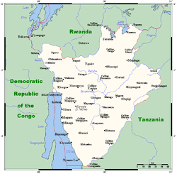
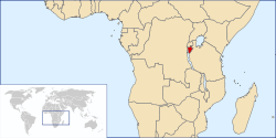
Geography of Burundi
Burundi is located in central Africa, to the east of the Democratic Republic of the Congo, at the coordinates 3°30′S 30°0′E.
  | |
| Continent | Africa[1] |
|---|---|
| Region | Central Africa |
| Coordinates | 3°30′S 30°0′E |
| Area | Ranked 142nd |
| • Total | 27,830 km2 (10,750 sq mi) |
| • Land | 92.2% |
| • Water | 7.8% |
| Coastline | 0 km (0 mi) |
| Borders | 1,140 km (DRC 236 km, Rwanda 315 km, Tanzania 589 km) |
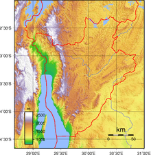
| Highest point | Mount Heha 2684 m |
| Lowest point | Lake Tanganyika 772 m |
| Longest river | Ruvubu 300 km |
| Largest lake | Lake Tanganyika |
Physical geography
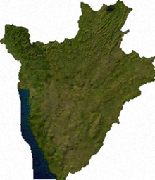
Burundi occupies an area equal to 27,830 square kilometres (10,750 sq mi) in size, of which 25,680 square kilometres (9,920 sq mi) is land. The country has 1,140 kilometres (710 mi) of land border: 236 kilometres (147 mi) of which is shared with the Democratic Republic of the Congo, 315 kilometres (196 mi) with Rwanda and 589 kilometres (366 mi) with Tanzania. As a landlocked country, Burundi possesses no coastline. It straddles the crest of the Congo-Nile Divide which separates the basins of the Congo and Nile rivers. The farthest headwaters of the Nile, the Ruvyironza River, has its source in Burundi.
Climate
Burundi in general has a tropical highland climate, with a considerable daily temperature range in many areas. Temperature also varies considerably from one region to another, chiefly as a result of differences in altitude. The central plateau enjoys pleasantly cool weather, with an average temperature of 20 °C (68 °F). The area around Lake Tanganyika is warmer, averaging 23 °C (73.4 °F); the highest mountain areas are cooler, averaging 16 °C (60.8 °F). Bujumbura’s average annual temperature is 23 °C (73.4 °F). Rain is irregular, falling most heavily in the northwest. Dry seasons vary in length, and there are sometimes long periods of drought. However, four seasons can be distinguished: the long dry season (June–August), the short wet season (September–November), the short dry season (December–January), and the long wet season (February–May). Most of Burundi receives between 1,300 and 1,600 mm (51.2 and 63.0 in) of rainfall a year. The Ruzizi Plain and the northeast receive between 750 and 1,000 mm (29.5 and 39.4 in)
Terrain

The terrain of Burundi is hilly and mountainous, dropping to a plateau in the east. The southern and eastern plains have been categorised by the World Wildlife Fund as part of the Central Zambezian Miombo woodlands ecoregion.
The lowest point in the country is at Lake Tanganyika, at 772 metres (2,533 ft), with the highest point being on Mount Heha, at 2,684 metres (8,806 ft).[2] Natural hazards are posed in Burundi by flooding and landslides.
Natural resources
Burundi possesses reserves of: nickel, uranium, rare earth oxides, peat, cobalt, copper, platinum (not yet exploited), vanadium, niobium, tantalum, gold, tin, tungsten, kaolin, and limestone. There is also arable land and the potential for hydropower. Burundi has 214.3 square kilometres (82.7 sq mi) of land that is irrigated. The table below describes land use in Burundi.
| Use | Percentage of Area |
|---|---|
| arable land | 42.83 |
| permanent crops | 13.63 |
| other | 43.54 |
Environment
Current issues
Soil erosion is an issue for Burundi, and is as a result of overgrazing and the expansion of agriculture into marginal lands. Other issues include: deforestation, due to the uncontrolled cutting-down of trees for fuel; and habitat loss threatens wildlife populations.
International agreements
Burundi is a party to the following international agreements that relate to the environment: Biodiversity, Climate Change, Desertification, Endangered Species, Hazardous Wastes and Ozone Layer Protection. The following have been signed but not yet ratified by Burundi: Law of the Sea and Nuclear Test Ban.
Extreme points
This is a list of the extreme points of Burundi, the points that are farther north, south, east or west than any other location.
- Northernmost point – unnamed location on the border with Rwanda immediately south of the Rwandna town of Mbuye, Muyinga Province
- Easternmost point – unnamed location on the border with Tanzania immediately northwest of Mburi hill, Cankuzo Province
- Southernmost point – unnamed location on the border with Tanzania immediately north of the Tanzanian town of Mwenene, Makamba Province
- Westernmost point – unnamed location on the border the Democratic Republic of the Congo immediately east of the Congolese town of Kamanyola, Cibitoke Province
References
![]()