Geography of Mozambique
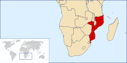
The geography of Mozambique consists mostly of coastal lowlands with uplands in its center and high plateaus in the northwest. There are also mountains in the western portion. The country is located on the east coast of southern Africa, directly west of the island of Madagascar. Mozambique has a tropical climate with two seasons, a wet season from October to March and a dry season from April to September.
 | |
| Continent | Africa |
|---|---|
| Region | East Africa |
| Coordinates | 18°15′S 35°00′E |
| Area | Ranked 35th |
| • Total | 801,590 km2 (309,500 sq mi) |
| • Land | 98.37% |
| • Water | 1.63% |
| Coastline | 2,500 km (1,600 mi) |
| Borders | None |
| Highest point | Monte Binga 2,436 metres (7,992 ft) |
| Lowest point | Indian Ocean 0 metres (0 ft) |
| Exclusive economic zone | 578,986 km2 (223,548 sq mi) |

Physical features
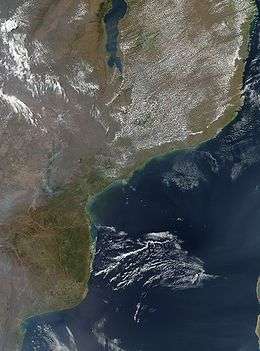
The Coast
The coastline extends from 26° 52′ S. to 10° 40′ S., and from south to north makes a double curve with a general trend outward to the east. It has a length of 1,430 miles (2,300 km).
The southern coastline is characterized by sandy beaches backed by coastal dunes. The dunes can reach up to 120 meters in height, and older dunes are vegetated. Behind the coastal dunes are lagoons, including river estuaries, closed saline lagoons, and salt lakes.[2] Some 40 miles (64 km) north of the South African frontier is the deep indentation of Maputo Bay (formerly Delagoa Bay). The land then turns outward to Cape Correntes, a little north of which is Inhambane Bay. Bending westward again and passing the Bazaruto Archipelago of several small islands, of which the chief is Bazaruto.
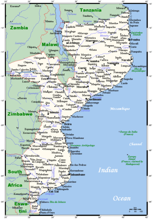
Mozambique's central coast, from Bazaruto Island north to Angoche Island, is known as the Bight of Sofala or Sofala Bay. It is also known as the Swamp Coast, and is characterized by extensive mangrove swamps and coastal wetlands. As in the south, the coastline is generally low, and harbours are few and poor. Beira is the principal seaport on the central coast, with rail and highway links to the interior.
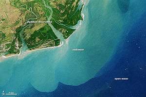
The bay has an area of 801,590 km2 (309,500 sq mi). The continental shelf is up to 140 km wide at Beira, and is Mozambique's most important marine fishery. Several large rivers, including the Save, Pungwe, and Zambezi, create costal estuaries and river deltas, of which the Zambezi delta is the largest.[3] North of the Zambezi, the small coralline islands of the Primeiras and Segundas Archipelago lie parallel to the coast.
The northern coast is much indented, abounding in rocky headlands and rugged cliffs, with an almost continuous fringe of islands. On one of these islands is Mozambique, and immediately north of that port is Conducia Bay. Somewhat farther north are two large bays, Fernao Veloso Bay and Memba Bay. Nacala on Fernao Veloso Bay is the principal seaport on the northern coast, with a rail link to Malawi and the coalfields of northwestern Mozambique. North of Fernao Veloso and Memba bays is Pemba Bay, where there is commodious anchorage for heavy draught vessels. North of Pemba Bay the Quirimbas Islands lie offshore, and numerous bays and estuaries indent the coast. Cape Delgado, the northernmost point on Mozambique's coast, is part of the delta of the Ruvuma River, which forms Mozambique's border with Tanzania.
The northern coast is part of the East African coral coast, a marine ecoregion that extends along the coasts of northern Mozambique, Tanzania, and Kenya.[4] Along the northern coast the Mozambique Current, which flows south between Madagascar and the mainland, is close to the coast and scours out all the softer material, while at the same time the corals are building in deep waters.
Orography
Orographically the backbone of the country is the mountain chain which forms the eastern escarpment of the continental plateau. It does not present a uniformly abrupt descent to the plains, but in places, as in the lower Zambezi district, slopes gradually to the coast. The Lebombo Mountains, behind Delagoa Bay, nowhere exceed 2,070 ft (631 m) in height. The Manica Plateau, farther north between the Save and Zambezi rivers, is higher, rising towards the Eastern Highlands along the border with Zimbabwe. Monte Binga (2,440 m or 8,005 ft), on the border with Zimbabwe, is Mozambique's highest peak. Mount Gorongosa (6,550 ft or 1,996 m) lies north-east of the Manica Plateau, and is, like it, of granitic formation. Gorongosa, rising isolated with precipitous outer slopes, has been likened in its aspect to a frowning citadel. East of Gorongosa a graben valley extends from the Zambezi to Pungwe Bay, the southern extension of the African Rift Valley. The Cheringoma Plateau lies east of the graben, sloping gently towards the coast.
The chief mountain range lies north of the Zambezi, and east of Lake Chilwa, namely, the Namuli Mountains, in which Namuli Peak rises to 8,860 ft (2,701 m), and Molisani, Mruli and Mresi attain altitudes of 6,500 to 8,000 ft (1,981 to 2,438 m) These mountains are covered with magnificent forests. Farther north the river basins are divided by well-marked ranges with heights of 3,000 ft (914 m) and over. Near the south-east shore of Lake Malawi there is a high range (5,000 to 6,000 ft or 1,524 to 1,829 m with an abrupt descent to the lake - some 3,000 ft or 914 m in 6 mi or 9.7 km. The country between Malawi and Ibo is remarkable for the number of fantastically-shaped granite peaks, or inselbergs, which rise from the plateau.
The plateau lands west of the escarpment are of moderate elevation - perhaps averaging 2,000 to 2,500 ft or 610 to 762 m It is, however, only along the Zambezi and north of that river that Mozambique's territory reaches to the continental plateau. This northern plain has been categorised by the World Wildlife Fund as part of the Eastern Miombo woodlands ecoregion.
Rivers
Besides the Zambezi, the most considerable river in Mozambique is the Limpopo which enters the Indian Ocean about 100 miles (161 km) north of Maputo Bay. The other Mozambican rivers with considerable drainage areas are the Komati, Save, Buzi, and Pungwe south of the Zambezi, and the Licungo (Likungo), Ligonha, Lúrio, Montepuez (Montepuesi or Mtepwesi), Messalo (or Msalu), and Ruvuma (or Rovuma) with its affluent the Lugenda (or Lujenda), north of the Zambezi.
The Save (or Sabi) rises in Zimbabwe at an altitude of over 3,000 ft (914 m), and after flowing south for over 200 miles (322 km) turns east and pierces the mountains some 170 miles (274 km) from the coast, being joined near the Zimbabwe-Mozambique frontier by the Lundi. Cataracts entirely prevent navigation above this point. Below the Lundi confluence the bed of the Save becomes considerably broader, varying from half a mile to two miles (3 km). In the rainy season the Save is a large stream and even in the "dries" it can be navigated from its mouth by shallow draught steamers for over 150 miles. Its general direction through Portuguese territory is east by north. At its mouth it forms a delta 60 miles (97 km) in extent.
The Buzi (220 miles) and Pungwe (180 miles) are streams north of and similar in character to the Save. They both rise in the Manica Highlands and enter the ocean in a large estuary, their mouths a mile or two apart. The lower reaches of both streams are navigable, the Buzi for 25 miles (40 km), the Pungwe for about 2 miles (3.2 km). The port of Beira is at the mouth of the Pungwe.
Of the north-Zambezi streams the Licungo, rising in the hills south-east of Lake Chilwa, flows south and enters the ocean not far north of Quelimane. The Lúrio, rising in the Namuli Mountains, flows north-east, having a course of some 200 miles (322 km). The Montepurez and the Messalo drain the country between the Lúrio and Ruvuma basins. Their banks are in general well-defined and the wet season rise seems fairly constant.
Somali Plate
Geologists have divided the Phanerozoic era of Mozambique's geology into the Karoo and post-Karoo era. This terminology is mostly used pertaining to studies of the structural and stratigraphic composition of rocks in the Zambezi valley.[5] Mozambique entirely lies within the Somali Plate.[6]
Climate
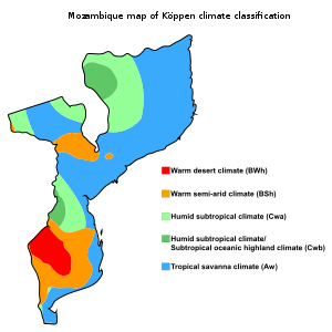
Mozambique has a tropical climate with two seasons, a wet season from October to March and a dry season from April to September. Climatic conditions vary depending on altitude. Rainfall is heavy along the coast and decreases in the north and south.
Annual precipitation varies from 500 to 900 mm (19.7 to 35.4 in) depending on the region with an average of 590 mm (23.2 in). Cyclones are also common during the wet season. Average temperature ranges in Maputo are from 13 to 24 °C (55.4 to 75.2 °F) in July to 22 to 31 °C (71.6 to 87.8 °F) in February.
Facts
Area:
total:
801,590 km2 (309,500 sq mi)
land:
786,380 km²
water:
13,000 km²
Capital
- Maputo (Lourenço Marques)
Major Cities
Other Cities
- Angoche (António Enes)
Land boundaries:
total: 4,571 km
border countries:
Malawi 1,569 km, South Africa 491 km, Swaziland 105 km, Tanzania 756 km, Zambia 419 km, Zimbabwe 1,231 km
Coastline: 2,470 km
Maritime claims:
territorial sea:
12 nmi (22.2 km; 13.8 mi)
exclusive economic zone:
578,986 km2 (223,548 sq mi) and 200 nmi (370.4 km; 230.2 mi)
Elevation extremes:
lowest point:
Indian Ocean 0 m
highest point:
Monte Binga 2 436 m
Natural resources: coal, titanium, natural gas, hydropower, tantalum, graphite
Land use:
arable land:
6.51% (2011), 5.43% (2005 est.), 3.98% (1998 est.)
permanent crops:
0.25% (2011), 0.29% (2005 est.), 0.29% (1998 est.)
other:
93.24% (2011), 94.28% (2005 est.), 95.73% (1998 est.)
Irrigated land: 1,181 km² (2003)
Total renewable water resources: 217.1 km3 (2011)
Natural hazards: severe droughts; devastating cyclones and floods occur in central and southern provinces
Environment - current issues: a long civil war and recurrent drought in the hinterlands have resulted in increased migration of the population to urban and coastal areas with adverse environmental consequences; desertification; pollution of surface and coastal waters; elephant poaching for ivory is a problem
Environment - international agreements:
party to:
Biodiversity, Climate Change, Climate Change-Kyoto Protocol, Desertification, Endangered Species, Hazardous Wastes, Law of the Sea, Ozone Layer Protection, Ship Pollution, Wetlands
Ecoregions
- Eastern Miombo woodlands
- Eastern Zimbabwe montane forest-grassland mosaic
- Maputaland coastal forest mosaic
- Southern Miombo woodlands
- Southern Rift montane forest-grassland mosaic
- Southern Zanzibar-Inhambane coastal forest mosaic
- Zambezian coastal flooded savanna
- Zambezian flooded grasslands
- Zambezian halophytics
- Zambezian and Mopane woodlands
- East African mangroves
Extreme points
This is a list of the extreme points of Mozambique, the points that are farther north, south, east or west than any other location.
- Northernmost point - Mouth of the Rovuma River, Cabo Delgado Province
- Easternmost point - unnamed headland east of the village of Amade, Nampula Province
- Southernmost point - unnamed location on the border with South Africa east of the South African town of Mosi, Maputo Province
- Westernmost point - the point where the border with Zambia enters the Luangwa river, Tete Province
References

- NASA - Zambezi
- Pereira, Marcos & Litulo, Carlos & Santos, Rodrigo & Costa Leal, Miguel & Fernandes, Raquel & Tibirica, Yara & Williams, Jess & Atanassov, Boris & Carreira, Filipa & Massingue, Alice & Marques da Silva, Isabel. (2014). Mozambique marine ecosystems review. 10.13140/2.1.2092.5766.
- Pereira, Marcos & Litulo, Carlos & Santos, Rodrigo & Costa Leal, Miguel & Fernandes, Raquel & Tibirica, Yara & Williams, Jess & Atanassov, Boris & Carreira, Filipa & Massingue, Alice & Marques da Silva, Isabel. (2014). Mozambique marine ecosystems review. 10.13140/2.1.2092.5766.
- Spalding, Mark D., Helen E. Fox, Gerald R. Allen, Nick Davidson et al. "Marine Ecoregions of the World: A Bioregionalization of Coastal and Shelf Areas". Bioscience Vol. 57 No. 7, July/August 2007, pp. 573-583.
- Nairn, Alan EM, Ian Lerche, and James E. Iliffe. "Geology, basin analysis, and hydrocarbon potential of Mozambique and the Mozambique Channel." Earth-Science Reviews 30.1-2 (1991): 81-123.
- Emerick, C. M., and R. A. Duncan. "Age progressive volcanism in the Comores Archipelago, western Indian Ocean and implications for Somali plate tectonics." Earth and Planetary Science Letters 60.3 (1982): 415-428.
External links
- "Mozambique". The World Factbook. Central Intelligence Agency.
- Weather in Mozambique from Free Tourist Information
- Mozambique Geography from Southern Africa Places
- Mozambique - Geography and Environment from Oxfam's "Cool Planet"
- Integrated geological interpretation of remotely sensed data to support geological mapping in Mozambique
- . Encyclopædia Britannica. 18 (11th ed.). 1911. p. 949.