Tonawanda Reservation
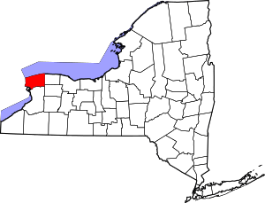
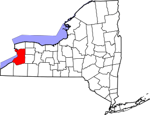
The Tonawanda Indian Reservation is an Indian reservation of the Tonawanda Seneca Nation located in western New York, United States. The band is a federally recognized tribe and, in the 2010 census, had 693 people living on the reservation. The reservation lies mostly in Genesee County, extending into Erie and Niagara counties. It is bordered by the Towns of Alabama, Pembroke, Newstead, and Royalton.
Tonawanda Reservation Tonawanda Creek Reservation | |
|---|---|
 Location of Tonawanda Reservation in New York | |
.svg.png) Location of New York in the United States | |
| Coordinates: 43°04′05″N 78°26′42″W | |
| Country | United States |
| State | New York |
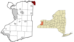
| Counties | Erie, Genesee, and Niagara |
| Area | |
| • Total | 0.80 sq mi (2.07 km2) |
| • Land | 0.80 sq mi (2.07 km2) |
| • Water | 0.00 sq mi (0.00 km2) |
| Population (2010) | |
| • Total | 2,662 |
| • Estimate (2016)[2] | 0 |
| • Density | 0.00/sq mi (0.00/km2) |
| Time zone | UTC-5 (EST) |
| • Summer (DST) | UTC-4 (EDT) |
| Area code(s) | 716 |
| Website | Seneca Nation of Indians |
The Tonawanda Reservation is also known as the Tonawanda Creek Reservation. Currently, it has more than a half dozen businesses located on Bloomingdale Road within the reservation. Several sell untaxed, low-price cigarettes and gasoline. Other businesses sell Seneca craft goods, groceries, and prepared food.
History
After various cultures of indigenous peoples succeeded each other in the Great Lakes area, in late prehistoric times, the five nations of the Iroquois coalesced. Before the mid-14th century, they had formed the Iroquois Confederacy. The Seneca were one of the Five Nations of the Haudenosaunee. The current location of the Tonawanda Reservation is believed to be close to the likely poorly-defined border between the historic Seneca homeland and its rivals, the Neutral Nation that occupied the Niagara Region at the time of French missionary Joseph de La Roche Daillon's arrival in the area in 1627. During the Beaver Wars of the 17th century, the Seneca invaded what is now Western New York, wiping out the Neutrals and other tribes in the region.
The Iroquois pledged allegiance to the British Crown in the Nanfan Treaty. During the French and Indian War, the Iroquois and British defeated New France; the Iroquois and other native territory was placed in a massive Indian Reserve. During the American Revolutionary War, most of the Iroquois sided with the British Crown, as they hoped to end colonial encroachment; to this effect, the Iroquois led several massacres on colonial settlements, which provoked the Continental Army to respond with the scorched-earth Sullivan Expedition, wiping out much of the Senecas' already destitute homelands. After the Crown's defeat, some of the Seneca, along with other Iroquois, migrated with Joseph Brant to the Grand River reservation in the still British-controlled territory of upper Canada (now known as the province of Ontario).
Those majority of the Seneca People remained in what is now western New York, subsequently ceding lands through the Canandaigua Treaty of 1794 and the Treaty of Big Tree in 1797 which led to the reservations in western New York.[3]
In 1848, the Seneca Nation of Indians was formed to represent the Seneca as a federally recognized tribe. Due to a dispute over one of the Treaties of Buffalo Creek, in which the Seneca Nation had attempted to sell the Tonawanda land to the Ogden Land Company without the residents' permission, the Tonawanda Band of Seneca Indians was formed in 1857 to represent the Tonawanda territory. In contrast to the Seneca Nation of Indians, which uses an American-style republican form of government, the Tonawanda Band of Seneca Indians preserves the traditional Seneca practices, including selection of life chiefs by heritage.
The Seneca of this reservation worked with self-taught anthropologist Lewis H. Morgan in mid century to teach him about the Iroquois kinship and social structures. He published the results of his work in 1851 as The League of the Ho-de-no-sau-nee or Iroquois. His insights about the significance and details of kinship structure in Native American societies influenced much following anthropological and ethnological research. Much of the information was provided by his colleague and friend Ely S. Parker, a Seneca born on the reservation in 1828. Morgan dedicated his book to Parker and credited him with their joint research.
Over the years, the size of the reservation has been reduced by sales of land to surrounding communities. The reservation is also noticeably more racially integrated than most Seneca Nation of Indians territories (excluding Salamanca, which operates on a lease system); whereas the Seneca Nation has actively resisted non-native settlement of its territories, the Tonawanda Band has been somewhat more tolerant of allowing non-natives to live on its territory.
Geography
According to the United States Census Bureau, the part in Niagara County has a total area of 0.8 mi² (2.1 km²) and none of the area is covered with water. The Census Bureau reports the part of the reservation in Genesee County has a total area of 9.3 mi² (24.0 km²). 9.2 mi² (23.8 km²) of it is land and 0.1 mi² (0.2 km²) of it (0.76%) is water. The Census Bureau reports the part in Erie County has a total area of 1.8 mi² (4.8 km²). None of the area is covered with water.
The Tonawanda Creek flows through the entire reservation to the Niagara River, separating the part in Niagara County from the parts in Erie and Genesee counties. The river constitutes a barrier. Together with the absence of paved roads, these factors limit the population in this part of the reservation.
The northern boundary of the reservation's Niagara County portion is part of the Tonawanda Wildlife Management Area.
Demographics
| Historical population | |||
|---|---|---|---|
| Census | Pop. | %± | |
| Est. 2016 | 0 | [2] | |
| U.S. Decennial Census[4] | |||
The United States Census Bureau compiles separate demographic data for each county's portion of the reservation.[5]
Erie County

At the 2010 census there were 34 people, 9 households, and 7 families living in the Indian reservation. The population density was 18.4 people per square mile (11.4/km²). There were 9 housing units at an average density of 2.7/mi² (1.0/km²).[5] There were 9 households, out of which three consisted of a married couple living together and two were made of a single individual. One household had someone living alone who was 65 or older. The average household size was 3.78 and the average family size was 4.43.
The age distribution was eighteen person under the age of 20, four people from 20 to 24, nine people from 25 to 44, one person from 45 to 64, and three persons 65 or older. The median age was 19.5 years. Nineteen of the reservation's residents were female and fifteen were male.
The median household income was in the Indian reservation was $21,250. The per capita income for the Indian reservation is $20,950. None of the population were below the poverty line. Median incomes per family were not reported. <-Figures specific to the Tonawanda Reservation is not included in the 2000 or 2010 census data. What was the source? [6]
Genesee County
At the 2000 census there were 533 people, 186 households, and 121 families living in the Indian reservation. The population density was 58.0/mi² (22.4/km²). There were 192 housing units at an average density of 20.9/mi² (8.1/km²). The racial makeup of the Indian reservation was 52.53% White, 2.63% Black or African American, 39.40% Native American, 0.19% Pacific Islander, 2.44% from other races, and 2.81% from two or more races. Hispanic or Latino of any race were 4.88%.[5]
Of the 86 households 32.3% had children under the age of 18 living with them, 44.6% were married couples living together, 13.4% had a female householder with no husband present, and 34.9% were non-families. 27.4% of households were one person and 10.8% were one person aged 65 or older. The average household size was 2.87 and the average family size was 3.49.
The age distribution was 29.8% under the age of 18, 9.9% from 18 to 24, 26.3% from 25 to 44, 21.0% from 45 to 64, and 12.9% 65 or older. The median age was 35 years. For every 100 females, there were 97.4 males. For every 100 females age 18 and over, there were 84.2 males.
The median household income was $25,208 and the median family income was $36,563. Males had a median income of $31,250 versus $12,159 for females. The per capita income for the Indian reservation was $12,201. About 12.3% of families and 16.1% of the population were below the poverty line, including 16.5% of those under age 18 and 16.1% of those age 65 or over.
Niagara County
At the 2010 census there are no people living in the location.[5]
Education
Residents living on the Tonawanda Reservation are included in the Akron school district.
See also
- Tonawanda Band of Seneca Indians
References
- "2016 U.S. Gazetteer Files". United States Census Bureau. Retrieved Jul 5, 2017.
- "Population and Housing Unit Estimates". Retrieved June 9, 2017.
- Treaty of Canandaigua, Edited by G. Peter Jemison & Anna M. Schein; Iroquois Land Claims Edited by Christopher Vecsey & William A. Starna
- "Census of Population and Housing". Census.gov. Retrieved June 4, 2016.
- "U.S. Census website". United States Census Bureau. Retrieved 2008-01-31.
- "U.S. Census website". United States Census Bureau. Retrieved 2019-07-26.
External links
| Wikimedia Commons has media related to Tonawanda Reservation. |
Municipalities and communities of Genesee County, New York, United States | ||
|---|---|---|
County seat: Batavia | ||
| City | 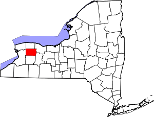 | |
| Towns | ||
| Villages | ||
| CDP | ||
| Hamlets | ||
| Indian reservation | ||
| Footnotes | ‡This populated place also has portions in an adjacent county or counties | |