Eudlo, Queensland
Eudlo is a small hinterland town and locality on the Sunshine Coast in Queensland, Australia.[2][3] In the 2016 census, Eudlo had a population of 1117 people.[1]
| Eudlo Sunshine Coast, Queensland | |||||||||||||||
|---|---|---|---|---|---|---|---|---|---|---|---|---|---|---|---|
 Eudlo | |||||||||||||||
| Coordinates | 26.7261°S 152.9588°E | ||||||||||||||
| Population | 1,117 (2016 census)[1] | ||||||||||||||
| • Density | 55.30/km2 (143.2/sq mi) | ||||||||||||||
| Postcode(s) | 4554 | ||||||||||||||
| Area | 20.2 km2 (7.8 sq mi) | ||||||||||||||
| Location | 94 km (58 mi) from Brisbane | ||||||||||||||
| LGA(s) | Sunshine Coast Region | ||||||||||||||
| State electorate(s) | Buderim | ||||||||||||||
| Federal Division(s) | Fisher | ||||||||||||||
| |||||||||||||||
Geography
Eudlo Creek rises in the south west of Eudlo. Also in the areas is Mossy Bank Mountain, a summit along an easterly protruding spur of the Blackall Range.
History

The name of Eudlo originated from the local Aboriginal term for the fresh water eel (Anguilla reinhardtii).[4]
Cattlemen and timbergetters came to the area from the 1860s, but land was not made available for agricultural selection until the 1880s. The first selector was James Steele in 1887.
In 1891, the section of the North Coast railway line from Landsborough to Yandina was opened. It brought closer settlement to the whole district, and facilitated the transport of passengers, timber, fruit and produce.
Eudlo Post Office opened on 1 March 1891.[5]
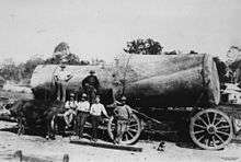
A sawmill was built at Eudlo and large quantities of timber from the Blackall Range, and surrounding forests, were either treated at the mill or railed to other centres. The timber industry was the means of livelihood for the early settlers.
Eudlo State School was opened on 6 September 1897.[6]
At the 2011 census Eudlo recorded a population of 1,128.[7]
Education
Eudlo State School is a government primary (Prep-6) school for boys and girls at Cnr Highlands Road & Rosebed Street (26.7264°S 152.9581°E).[8][9] In 2017, the school had an enrolment of 58 students with 10 teachers (4 full-time equivalent) and 7 non-teaching staff (3 full-time equivalent).[10]
Amenities
The Sunshine Coast Regional Council operates a mobile library service which visits the Community Hall at Rosebed Street.[11]
See also
References
- Australian Bureau of Statistics (27 June 2017). "Eudlo (SSC)". 2016 Census QuickStats. Retrieved 20 October 2018.

- "Eudlo - town in the Sunshine Coat Region (entry 11909)". Queensland Place Names. Queensland Government. Retrieved 28 September 2017.
- "Eudlo - locality in the Sunshine Coast Region (entry 49684)". Queensland Place Names. Queensland Government. Retrieved 28 September 2017.
- "Place Name Origins - Maroochy Shire Council". Maroochy Shire. 2006. Archived from the original on 10 December 2006.
- Premier Postal History. "Post Office List". Premier Postal Auctions. Retrieved 10 May 2014.
- "Opening and closing dates of Queensland Schools". Queensland Government. Retrieved 2 October 2015.
- Australian Bureau of Statistics (31 October 2012). "Eudlo (State Suburb)". 2011 Census QuickStats. Retrieved 8 October 2014.
- "State and non-state school details". Queensland Government. 9 July 2018. Archived from the original on 21 November 2018. Retrieved 21 November 2018.
- "Eudlo State School". Retrieved 21 November 2018.
- "ACARA School Profile 2017". Archived from the original on 22 November 2018. Retrieved 22 November 2018.
- "Libraries: Mobile timetable". Sunshine Coast Regional Council. Archived from the original on 30 January 2018. Retrieved 30 January 2018.
External links
| Wikimedia Commons has media related to Eudlo, Queensland. |
- "Eudlo". Queensland Places. Centre for the Government of Queensland, University of Queensland.
- Town map of Eudlo, 1974