Kenilworth, Queensland
Kenilworth is a small town and locality in the heart of the Mary Valley area of the Sunshine Coast, Queensland, Australia.[2][3] This is a rural area, about 50 kilometres (31 mi) from the coast, with dairy farming as the major industry. Local visitor attractions include a cheese factory as well as walking, camping and 4-wheel driving in the Kenilworth State Forest.
| Kenilworth Sunshine Coast, Queensland | |||||||||||||||
|---|---|---|---|---|---|---|---|---|---|---|---|---|---|---|---|
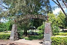 Kenilworth Town Park | |||||||||||||||
 Kenilworth | |||||||||||||||
| Coordinates | 26°35′S 152°44′E | ||||||||||||||
| Population | 559 (2011 census)[1] | ||||||||||||||
| Postcode(s) | 4574 | ||||||||||||||
| Location | |||||||||||||||
| LGA(s) | Sunshine Coast Region | ||||||||||||||
| State electorate(s) | |||||||||||||||
| Federal Division(s) | |||||||||||||||
| |||||||||||||||
History
Dalla (also known as Dalambara and Dallambara) is a language of the Upper Brisbane River catchment, notably the Conondale Range. Dalla is part of the Duungidjawu language region includes the landscape within the local government boundaries of the Somerset and Moreton Bay Regional Councils, particularly the towns of Caboolture, Kilcoy, Woodford and Moore.[4]
The Mary River was known to the Aboriginals as the Numabulla and the name for the Kenilworth area being Hinka Booma. In 1842 Andrew Petrie named the river as the Wide Bay River. In 1847 that Governor Fitzroy renamed the river after his wife Mary.[5]
Richard Joseph Smith tendered to set up the first cattle run on the east bank of the Mary River in 1850. At the time Mrs Smith was reading Sir Walter Scott's novel "Kenilworth" and she decided to name the property after the novel.[2]
In 1877, 17,280 acres (6,990 ha) of land was resumed from the Kenilworth North pastoral run to be used as small farmers. The land was offered for selection from 17 April 1877.[6]
During the second half of the 19th Century, the Smiths took up more land.
In October 1921 the Kenilworth Estate of 6,000 acres (2,400 ha) was auctioned having been subdivided into town lots, dairy blocks and grazing blocks. Up to £30 was paid for a town lot while the dairy blocks fetched up to £18 per acre and grazing blocks up to £7 per acre, realising a total of £46,000 from the sale overall.[7]
Other settlers arrived in 1891 originally intending to grow small crops. There was a ready market at the goldfields in Gympie but after the floods of 1893, 1895 and 1898 had wiped out their crops, most ventured into dairying and pig breeding. In 1901 the Kenilworth Farmers' Association was formed and in 1907 they built the Kenilworth Farmers Assembly Hall. This later housed a library and hosted dances. In 1905 the Association was responsible for establishing a co-operative butter factory which opened in Caboolture in 1907.
Also established was the Kenilworth Farmers' Co-operative Store in Eumundi. In 1912 a steam-powered sawmill was built on Coolabine Creek. In 1921 Kenilworth Station was sold off and divided into dairy farms and allotments. By 1925 all the large estates in the district had been subdivided and sold. Today dairying is still a major part of farming in the area but there has been diversification into fruit and vegetables and pig farming.
Kenilworth Post Office opened by 1926 (a receiving office had been open from 1896).[8]
The first store was opened in Kenilworth on 2 January 1924 as well as the new hall opening and the first butcher's shop appeared in 1925. Kenilworth Provisional School built by the community opened on 22 January 1900. This school became a State School on 1 January 1909. (This school was in the locality now known as Gheerulla).[9][10]
Kenilworth Township was opened in the Kenilworth Hall on 21 October 1924. The hall, in 1926, was equipped to show silent pictures. The site for a public recreation ground was purchased in 1927 and in 1933, the Public Hall was moved to this new location. The Church of England Mary Valley Parish was established in 1925.
The Kenilworth Library opened in 1986 with a major refurbishment in 2000.[11]
At the 2006 census, Kenilworth had a population of 238.[12]
In the 2011 census, Kenilworth had a population of 559 people.[1]
Attractions
Kenilworth has a 'Living History' Museum with a theatrette which shows a history of the district to visitors, together with displays covering many areas of history past.[13]
Kenilworth Homestead still exists, though the 10,000 hectare cattle station is now reduced to 50 hectares. Since 1875, the Homestead and out-buildings have continually been restored and extended, still keeping as much of its original structure as possible. It is now used as a camping and riding centre.
Heritage listings
Kenilworth has a number of heritage-listed sites, including:
- Eumundi-Kenilworth Road: Kenilworth Homestead[14]
Facilities
The Sunshine Coast Regional Council operates a public library at 4A Elizabeth Street.[15]
References
- Australian Bureau of Statistics (31 October 2012). "Kenilworth". 2011 Census QuickStats. Retrieved 24 July 2015.

- "Kenilworth (entry 17930)". Queensland Place Names. Queensland Government. Retrieved 24 July 2015.
- "Kenilworth (entry 48695)". Queensland Place Names. Queensland Government. Retrieved 24 July 2015.
-

- "Mary River (entry 21155)". Queensland Place Names. Queensland Government. Retrieved 24 July 2015.
- "Proclamations under the New Land Acts". The Brisbane Courier. Queensland, Australia. 2 March 1877. p. 3. Retrieved 20 February 2020 – via Trove.
- "GYMPIE". The Brisbane Courier. Queensland, Australia. 3 October 1921. p. 8. Retrieved 20 February 2020 – via Trove.
- Premier Postal History. "Post Office List". Premier Postal Auctions. Retrieved 10 May 2014.
- "Kenilworth SS". Archived from the original on 4 February 2017. Retrieved 30 January 2017.
- "Opening and closing dates of Queensland Schools". Queensland Government. Retrieved 18 April 2019.
- "Public Libraries Statistical Bulletin 2016-17" (PDF). Public Libraries Connect. State Library of Queensland. November 2017. p. 16. Archived (PDF) from the original on 30 January 2018. Retrieved 30 January 2018.
- Australian Bureau of Statistics (25 October 2007). "Kenilworth (L) (Urban Centre/Locality)". 2006 Census QuickStats. Retrieved 4 June 2011.
- "Kenilworth Museum". Archived from the original on 4 February 2017. Retrieved 30 January 2017.
- "Kenilworth Homestead (entry 602043)". Queensland Heritage Register. Queensland Heritage Council. Retrieved 14 July 2013.
- "Kenilworth Library". plconnect.slq.qld.gov.au. Archived from the original on 21 March 2019. Retrieved 30 January 2018.
External links
| Wikimedia Commons has media related to Kenilworth, Queensland. |
- Aerial and other video of Kenilworth and the Mary River Valley
- University of Queensland: Queensland Places: Kenilworth
- Kenilworth Town Website - Includes visitor and other information for the upper Mary Valley region.