D'Aguilar, Queensland
D'Aguilar is a rural township and locality in the Moreton Bay Region, Queensland, Australia.[2][3] It is located northwest of the larger centre of Caboolture. In the 2011 census, the locality recorded a population of 830 persons, living in 255 inhabited dwellings, all of which were detached houses.[1]
| D'Aguilar Queensland | |||||||||||||||
|---|---|---|---|---|---|---|---|---|---|---|---|---|---|---|---|
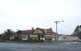 D'Aguilar Hotel | |||||||||||||||
| Population | 1,207 (2016 census)[1] | ||||||||||||||
| Postcode(s) | 4514 | ||||||||||||||
| Location |
| ||||||||||||||
| LGA(s) | Moreton Bay Region | ||||||||||||||
| State electorate(s) | Glass House | ||||||||||||||
| Federal Division(s) | Longman | ||||||||||||||
| |||||||||||||||
D'Aguilar lies on the D'Aguilar Highway between Wamuran and Woodford. It is also the northern endpoint of Mount Mee Road, which leads south through Delaneys Creek and Mount Mee to Dayboro. A small section of the Beerburrum West State Forest is in D'Aguilar.
The town is named for Major General Sir George D'Aguilar, a military officer who wrote Regulations and Punishments of the British Army, the army textbook in use at the time of the town's establishment.[4] As time passed, the mountain range that the town is situated in came to be named after the town.
References
- Australian Bureau of Statistics (27 June 2017). "D'Aguilar (State Suburb)". 2016 Census QuickStats. Retrieved 29 January 2018.

- "D'Aguilar - town in Moreton Bay Region (entry 9157)". Queensland Place Names. Queensland Government. Retrieved 28 September 2017.
- "D'Aguilar - locality in Moreton bay Region (entry 49226)". Queensland Place Names. Queensland Government. Retrieved 28 September 2017.
- "Caboolture Town History". Archived from the original on 28 May 2008. Retrieved 6 May 2008.