Crownpoint, New Mexico
Crownpoint (Navajo: Tʼiistsʼóóz Ńdeeshgizh) is a census-designated place (CDP) in McKinley County, New Mexico, United States founded in 1912. The population was 2,278 at the 2010 census.[1]
Crownpoint, New Mexico | |
|---|---|
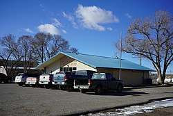 Crownpoint Post Office | |
 Location of Crownpoint, New Mexico | |
 Crownpoint, New Mexico Location in the United States | |
| Coordinates: 35°41′9″N 108°8′54″W | |
| Country | United States |
| State | New Mexico |
| County | McKinley |
| Area | |
| • Total | 7.0 sq mi (18 km2) |
| • Land | 7.0 sq mi (18 km2) |
| • Water | 0.0 sq mi (0 km2) |
| Elevation | 6,982 ft (2,128 m) |
| Population | |
| • Total | 2,278 |
| • Density | 330/sq mi (130/km2) |
| Time zone | UTC-7 (Mountain (MST)) |
| • Summer (DST) | UTC-6 (MDT) |
| ZIP code | 87313 |
| Area code(s) | 505 |
| FIPS code | 35-18940 |
| GNIS feature ID | 0902810 |
It is on the Trails of the Ancients Byway, one of the designated New Mexico Scenic Byways.[2]
In 1912, Crownpoint was founded by Samuel F. Stacher as an Indian Agency to serve the Navajo People in the Pueblo Bonito Agency of Northwestern New Mexico. A school house, agency office and power house were first built to accommodate future planned establishments.
Chief Becenti, a local Navajo headman, is one of the first documented leaders of the area. He resided north of Crownpoint, where later in the 1930s a small community would be named after him, called Becenti Lake.
In June 1965, Crownpoint was recognized as a local chapter government sub-unit of the Navajo Nation Government. There are currently 110 Navajo Chapters across the Navajo Nation. Crownpoint Chapter is the center of Eastern Navajo Agency and many tribal offices are located in the community. There are currently 31 Navajo Chapters in Eastern Navajo Agency.
Jonathan Perry is the current Council Delegate who serves on the 23rd Navajo Nation Council representing the community. Perry represents eight chapters, which are Becenti, Crownpoint, Huerfano, Lake Valley, Nahodishgish, Nageezi, Tse'ii'ahi and White Rock Chapters. He is serving his first term.
Geography
Crownpoint is located at 35°41′9″N 108°8′54″W (35.685890, -108.148350).[3]
According to the United States Census Bureau, the CDP has a total area of 7.0 square miles (18 km2), all of it land.[1]
Demographics
| Languages (2000)[4] | Percent |
|---|---|
| Spoke Navajo at home | 64.33% |
| Spoke English at home | 35.67% |
As of the census[5] of 2000, there were 2,630 people, 749 households, and 599 families residing in the CDP. The population density was 372.3 people per square mile (143.8/km2). There were 937 housing units at an average density of 132.6 per square mile (51.2/km2). The racial makeup of the CDP was 89.09% Native American, 8.78% White, 0.42% African American, 0.38% Asian, 0.23% from other races, 0.04% Pacific Islander, and 1.06% from two or more races. Hispanic or Latino of any race were 1.18% of the population.
There were 749 households, out of which 49.4% had children under the age of 18 living with them, 45.7% were married couples living together, 27.4% had a female householder with no husband present, and 19.9% were non-families. 17.4% of all households were made up of individuals, and 1.9% had someone living alone who was 65 years of age or older. The average household size was 3.51 and the average family size was 4.03.
In the CDP, the population was spread out, with 39.7% under the age of 18, 9.4% from 18 to 24, 27.6% from 25 to 44, 19.4% from 45 to 64, and 3.9% who were 65 years of age or older. The median age was 26 years. For every 100 females, there were 90.0 males. For every 100 females age 18 and over, there were 80.7 males.
The median income for a household in the CDP was $29,792, and the median income for a family was $31,384. Males had a median income of $25,040 versus $24,704 for females. The per capita income for the CDP was $9,964. About 26.1% of families and 27.3% of the population were below the poverty line, including 33.8% of those under age 18 and 19.6% of those age 65 or over.
References
- "2010 Census Gazetteer Files - Places: New Mexico". United States Census Bureau. Retrieved October 20, 2017.
- Trail of the Ancients. Archived August 21, 2014, at the Wayback Machine New Mexico Tourism Department. Retrieved August 14, 2014.
- "US Gazetteer files: 2010, 2000, and 1990". United States Census Bureau. 2011-02-12. Retrieved 2011-04-23.
- "Archived copy". Archived from the original on 2017-05-25. Retrieved 2017-03-24.CS1 maint: archived copy as title (link)
- "U.S. Census website". United States Census Bureau. Retrieved 2008-01-31.
Municipalities and communities of McKinley County, New Mexico, United States | ||
|---|---|---|
| City | 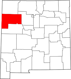 Map of New Mexico highlighting McKinley County | |
| CDPs | ||
| Unincorporated communities | ||
| Indian reservation | ||
| Footnotes | ‡This populated place also has portions in an adjacent county or counties | |