Ramah, New Mexico
Ramah (Navajo: Tłʼohchiní – place of wild onions) is a census-designated place (CDP) in McKinley County, New Mexico, United States. The population was 407 at the 2000 census, and 370 at the 2010 United States Census.
Ramah, New Mexico | |
|---|---|
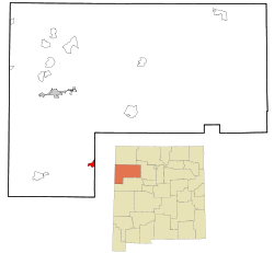 Location of Ramah, New Mexico | |
 Ramah, New Mexico Location in the United States | |
| Coordinates: 35°8′6″N 108°29′16″W | |
| Country | United States |
| State | New Mexico |
| County | McKinley |
| Area | |
| • Total | 3.8 sq mi (9.9 km2) |
| • Land | 3.8 sq mi (9.9 km2) |
| • Water | 0.0 sq mi (0.0 km2) |
| Elevation | 6,926 ft (2,111 m) |
| Population (2000) | |
| • Total | 407 |
| • Density | 106.9/sq mi (41.3/km2) |
| Time zone | UTC-7 (Mountain (MST)) |
| • Summer (DST) | UTC-6 (MDT) |
| ZIP code | 87321 |
| Area code(s) | 505 |
| FIPS code | 35-61220 |
| GNIS feature ID | 0909970 |
Geography
Ramah is located at 35°8′6″N 108°29′16″W (35.135013, -108.487798).[1] Its altitude is 6,926 feet (2,111 m).[2]
According to the United States Census Bureau, the CDP has a total area of 3.8 square miles (9.8 km2), all of it land.
Surrounding countryside
Established in 1876, Ramah was one of fifty locations in the New Mexico Territory settled, under the direction of Brigham Young, by Mormon pioneers and is one of only three that remain today. Ramah was originally settled for the purpose of missionary work to be carried out within the Zuni and Navajo communities. Many of the original stone houses are still standing and are a testament to the hard work and skill of Ramah's early founders. One such building has been restored and preserved as a museum to display the heritage of the valley's past.
Ramah Lake was built by these same pioneers in order to farm the surrounding area, which receives moderate rainfall on a yearly basis. The lake relies on snowfall and spring run off to sustain its water levels. This trait is shared by many areas in the state of New Mexico. In recent years, due to drought, the lake had dried up; the town irrigation committee used this low water level to make improvements including dredging a large amount of silt buildup and reinforcing the dam, allowing water to be used more efficiently. Modernization in irrigation has allowed water to be used more effectively.
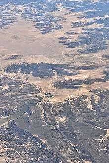
Lying at 6926 feet above sea level, Ramah is considered by some as a high desert, but at higher elevations in includes tall pines, sandstone cliffs, and timber covered mountains. Much of the lower landscape in the surrounding area is covered with lava flows from the chain of volcanos to the south. Intermixed in the scenery are ruins of an ancient people who dotted the land.
The Ramah Lake hiking trails and the neighboring El Morro, El Calderon, and El Malpais National Monuments offer hikers beautiful views of colorful sandstone cliffs and sprawling vistas, as well as a glimpse into the past life of the ancient people who build their stone structures and lived on the land.
Ramah lies between the Zuni Indian Reservation, the Ramah Navajo Indian Reservation, and the Cibola National Forest.[3] Wild Spirit Wolf Sanctuary, El Morro National Monument, and El Malpais National Monument are all located near the Ramah area.
Demographics
As of the census[4] of 2000, there were 407 people, 121 households, and 98 families residing in the CDP. The population density was 106.9 people per square mile (41.2/km²). There were 175 housing units at an average density of 46.0 per square mile (17.7/km²). The racial makeup of the CDP was 64.86% White, 25.80% Native American, 0.98% Pacific Islander, 0.74% from other races, and 7.62% from two or more races. Hispanic or Latino of any race were 6.63% of the population.
There were 121 households out of which 50.4% had children under the age of 18 living with them, 66.9% were married couples living together, 10.7% had a female householder with no husband present, and 18.2% were non-families. 17.4% of all households were made up of individuals and 8.3% had someone living alone who was 65 years of age or older. The average household size was 3.36 and the average family size was 3.81.
In the CDP, the population was spread out with 37.6% under the age of 18, 8.8% from 18 to 24, 24.6% from 25 to 44, 18.4% from 45 to 64, and 10.6% who were 65 years of age or older. The median age was 28 years. For every 100 females, there were 115.3 males. For every 100 females age 18 and over, there were 93.9 males.
The median income for a household in the CDP was $25,313, and the median income for a family was $35,278. Males had a median income of $17,143 versus $19,792 for females. The per capita income for the CDP was $10,419. About 23.0% of families and 31.2% of the population were below the poverty line, including 46.8% of those under age 18 and 11.9% of those age 65 or over.
Gallery
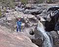 Ramah Falls
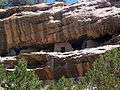 Ancient cliff dwellings in South Ramah
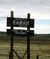 Ramah Welcome Sign
References
- "US Gazetteer files: 2010, 2000, and 1990". United States Census Bureau. 2011-02-12. Retrieved 2011-04-23.
- U.S. Geological Survey Geographic Names Information System: Ramah, New Mexico
- http://www.publiclands.org/explore/quadrant_map.php?plicstate=NM&quad=5
- "U.S. Census website". United States Census Bureau. Retrieved 2008-01-31.
External links
- Ramah High School Homepage
- Ramah Elementary School Homepage
- Ramah Museum
- El Morro Old School Gallery
- Along The Ancient Way – El Morro Valley Community Website
- Wild Spirit Wolf Sanctuary in Ramah
Municipalities and communities of McKinley County, New Mexico, United States | ||
|---|---|---|
| City | 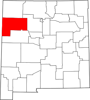 Map of New Mexico highlighting McKinley County | |
| CDPs | ||
| Unincorporated communities | ||
| Indian reservation | ||
| Footnotes | ‡This populated place also has portions in an adjacent county or counties | |