Cone Mountain
Cone Mountain is a summit in the Canadian Rockies of Alberta, Canada.[3] It is the southernmost peak in the Sundance Range.
| Cone Mountain | |
|---|---|
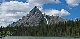
.jpg) Cone Mountain | |
| Highest point | |
| Elevation | 2,909 m (9,544 ft) [1] |
| Prominence | 394 m (1,293 ft) [1] |
| Coordinates | 50°53′24″N 115°27′47″W [2] |
| Geography | |
 Cone Mountain Location of Cone Mountain in Alberta  Cone Mountain Cone Mountain (Canada) | |
| Location | Alberta, Canada |
| Parent range | Canadian Rockies |
| Topo map | NTS 82J14[2] |
Cone Mountain was so named in 1915 on account of its shape.[4] The mountain's name became official in 1924 by the Geographical Names Board of Canada.[2]
Climate
Based on the Köppen climate classification, Cone Mountain is located in a subarctic climate zone with cold, snowy winters, and mild summers.[5] Temperatures can drop below −20 °C with wind chill factors below −30 °C. Precipitation runoff from Cone Mountain drains into the Bow River which is a tributary of the Saskatchewan River.
Geology
The mountain is composed of sedimentary rock laid down during the Precambrian to Jurassic periods. Formed in shallow seas, this sedimentary rock was pushed east and over the top of younger rock during the Laramide orogeny.[6]
References
- "Cone Mountain, Alberta". Peakbagger.com.
- "Cone Mountain". Geographical Names Data Base. Natural Resources Canada. Retrieved 2018-11-04.
- "Cone Mountain". Geographical Names Data Base. Natural Resources Canada.
- Place-names of Alberta. Ottawa: Geographic Board of Canada. 1928. p. 37.
- Peel, M. C.; Finlayson, B. L. & McMahon, T. A. (2007). "Updated world map of the Köppen−Geiger climate classification". Hydrol. Earth Syst. Sci. 11: 1633–1644. ISSN 1027-5606.
- Gadd, Ben (2008). "Geology of the Rocky Mountains and Columbias". Cite journal requires
|journal=(help)
.jpg)