Cirrus Mountain
Cirrus Mountain is a 3,270-metre (10,730-foot) mountain summit located in the upper North Saskatchewan River valley on the shared boundary between Banff National Park and White Goat Wilderness Area, in the Canadian Rockies of Alberta, Canada. Its nearest higher peak is Mount Stewart, 5.92 km (3.68 mi) to the north-northeast.[4] Cirrus Mountain is situated along the east side the Icefields Parkway midway between Saskatchewan Crossing and Sunwapta Pass.
| Cirrus Mountain | |
|---|---|
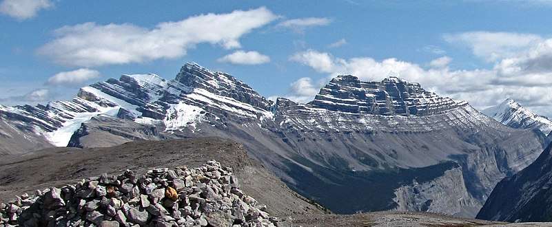 Cirrus Mountain with summit to left. Viewed from Parker Ridge | |
| Highest point | |
| Elevation | 3,270 m (10,730 ft) [1] |
| Prominence | 890 m (2,920 ft) [1] |
| Parent peak | Mount Stewart (3312 m)[1] |
| Listing | Mountains of Alberta |
| Coordinates | 52°10′10″N 116°58′38″W [2] |
| Geography | |
 Cirrus Mountain Location of Cirrus Mountain in Alberta  Cirrus Mountain Cirrus Mountain (Canada) | |
| Location | Alberta, Canada |
| Parent range | Canadian Rockies |
| Topo map | NTS 83C/02[2] |
| Type of rock | Sedimentary |
| Climbing | |
| First ascent | 1939 by C.B. Sissons, H.J. Sissons[3] |
| Easiest route | technical climb |
History
In 1928, Morrison P. Bridgland suggested the name Mount Huntington for the mountain, but it was not adopted.[3] However, the Huntington name endures as the name of the Huntington Glacier below the eastern aspect of the summit. The mountain was instead named Cirrus Mountain, and that became official in 1935.[2] The first ascent of the mountain was accomplished in 1939 by C.B. Sissons, H.J. Sissons.
Geology
Like other mountains in Banff Park, Cirrus Mountain is composed of sedimentary rock laid down from the Precambrian to Jurassic periods.[5] Formed in shallow seas, this sedimentary rock was pushed east and over the top of younger rock during the Laramide orogeny.[6] The east aspect of Cirrus Mountain is covered by expansive glacial ice known as the Huntington Glacier.
Climate
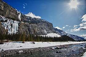
Based on the Köppen climate classification, Cirrus Mountain is located in a subarctic climate with cold, snowy winters, and mild summers.[7] Temperatures can drop below -20 °C with wind chill factors below -30 °C. Weather conditions during winter make the Weeping Wall at the base of Cirrus Mountain's west face the premier place for ice climbing in the Canadian Rockies. Precipitation runoff from Cirrus Mountain drains into tributaries of the North Saskatchewan River.
Ice Climbing Routes
Ice Climbing Routes with grades on Cirrus Mountain
.jpg)
References
- "Cirrus Mountain". Bivouac.com. Retrieved 2018-10-16.
- "Cirrus Mountain". Geographical Names Data Base. Natural Resources Canada. Retrieved 2018-10-14.
- "Cirrus Mountain". PeakFinder.com. Retrieved 2019-10-09.
- "Cirrus Mountain, Alberta". Peakbagger.com. Retrieved 2019-10-09.
- Belyea, Helen R. (1960). The Story of the Mountains in Banff National Park (PDF). parkscanadahistory.com (Report). Ottawa: Geological Survey of Canada. Archived (PDF) from the original on 2015-10-02. Retrieved 2019-09-13.
- Gadd, Ben (2008). Geology of the Rocky Mountains and Columbias.
- Peel, M. C.; Finlayson, B. L. & McMahon, T. A. (2007). "Updated world map of the Köppen−Geiger climate classification". Hydrol. Earth Syst. Sci. 11: 1633–1644. ISSN 1027-5606.
- "Lower Weeping Wall". MountainProject. Retrieved 2019-10-09.
- "Cirrus Mountain". SummitPost.org. Retrieved 2018-10-16.
See also
External links
- Weather forecast: Cirrus Mountain
- Parks Canada web site: Banff National Park