Babuganj Upazila
Babuganj (Bengali: বাবুগঞ্জ) is an administrative unit of Barisal District in the Division of Barisal, Bangladesh.[1]
Babuganj বাবুগঞ্জ | |
|---|---|
Upazila | |
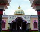 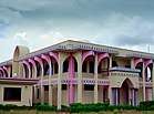 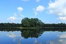 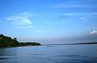 From top: Guthia Mosque, Guthia Mosque Orphanage, Durga Sagar, Sondha River Skyline of , Bangladesh | |
 Babuganj Location in Bangladesh | |
| Coordinates: 22°49.9′N 90°19.3′E | |
| Country | |
| Division | Barisal Division |
| District | Barisal District |
| Area | |
| • Total | 164.88 km2 (63.66 sq mi) |
| Population (1991) | |
| • Total | 135,905 |
| • Density | 820/km2 (2,100/sq mi) |
| Time zone | UTC+6 (BST) |
| Website | babuganj |
Geography
Babuganj is located at 22.8319°N 90.3222°E . It has 25,144 households and a total area of 164.88 km².
Demographics
According to the 1991 Bangladesh census, Babuganj had a population of 135,905. Males constituted 50.58% of the population, and females 49.42%. The population aged 18 or over was 66,984. Babuganj had an average literacy rate of 47.4% (7+ years), compared to the national average of 32.4%.[2]
Points of interest
Durgasagar
Durgasagar with an area of about 2,500 hectare, is the largest pond or dighi of southern Bangladesh. It is located at Madhabpasa village of Babuganj upazila, about 11 km away from Barisal town. Locally it is known as Madhabpasha Dighi. According to a desire of Rani Durgavati, mother of Raja Joynarayan, the dighi was dug in 1780 (1187 BS).
Administration
Babuganj has 6 Unions/Wards, 86 Mauzas/Mahallas, and 87 villages.
- Rahomatpur
- Chandpasha
- Kedarpur
- Madhabpasha
- Jahangirnagar
- Dehergoti
References
- Masud Parvez (2012). "Babuganj Upazila". In Sirajul Islam and Ahmed A. Jamal (ed.). Banglapedia: National Encyclopedia of Bangladesh (Second ed.). Asiatic Society of Bangladesh.
- "Population Census Wing, BBS". Archived from the original on 2005-03-27. Retrieved November 10, 2006.
| Upazila/Thana: | ||
|---|---|---|
Capital: Barisal | ||
| Barguna District | 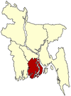 | |
| Barisal District | ||
| Bhola District |
| |
| Jhalokati District | ||
| Patuakhali District | ||
| Pirojpur District | ||