Cà Mau
Cà Mau (![]()
Cà Mau Thành phố Cà Mau | |
|---|---|
| Cà Mau City | |
 Cà Mau seen from the air | |
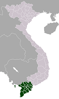
 Cà Mau Location of in Vietnam | |
| Coordinates: 9°11′N 105°9′E | |
| Country | |
| Province | Cà Mau |
| Area | |
| • Land | 250.3 km2 (96.6 sq mi) |
| Population (2018) | |
| • Total | 315,270 |
| • Density | 1,112.2/km2 (2,881/sq mi) |
| [1] | |
| Time zone | UTC+7 (Indochina Time) |
| Climate | Am |
| Website | Tỉnh Cà Mau |
The population is approximately 204,895 (as of 2010).[1] Cà Mau is accessible by road (360 km south-west of Ho Chi Minh City) via National Route 1A or by air (Cà Mau Airport). The city is administratively subdivided into 8 urban phường and 7 rural xã.[2]
Economy
Cà Mau is Vietnam's biggest exporter of shrimp and prawns. In 2005, Cà Mau province alone exported about $500 million of shrimp and prawns. A large petroleum project under construction, the Cà Mau Gas-Power-Fertilizer Complex, is valued at $1.4 billion. It includes:
- 2 thermal power plants with a total capacity of 1500 MW (equipment provided by the German company Siemens)
- A fertilizer plant with production capacity at 800,000 metric tonnes of urea/year, and
- A gas pipeline 18 inches in diameter to extend 298 km offshore and with 27 km onshore piping in gas from the PM3 gas field shared with Malaysia. Two billion cubic meters of gas are piped to feed these plants per year.
The project opened in December 2008.[3]
Tourism
Cà Mau has several attractions that draw domestic and international tourists. These include several wild bird parks, the southernmost point in Vietnam (called Mũi Cà Mau), and a number of pagodas. Near Cà Mau is the U Minh area with its famous mangrove forest and swamp cuisine: fish hot pots, Vietnamese, Chinese, and Khmer cuisines. Cà Mau also has several 1- to 3-star hotel restaurants.
History
During the 1st millennium, the region of the present Cà Mau province was part of the Kingdom of Funan (Vietnamese: Phù Nam), which included Laos, Cambodia, parts of eastern Thailand, and southern Vietnam (Vietnamese: Nam Bộ). This region was later conquered by the kingdom of Chenla (Vietnamese: Chân Lạp) and the Khmer Empire. In 1757, the land belonging to Cà Mau province (Khmer: ទឹកខ្មៅ, "the black land") was ceded by the Khmer king to the Nguyễn lord of Đàng Trong (central Vietnam) with an early settlement of Vietnamese people. During French rule, Cà Mau was only a small town. During the Republic of Vietnam, the area nearby Cà Mau was a stronghold (Vietnamese: Chiến khu cách mạng) for the Việt Cộng, a Hanoi-backed guerrilla group fighting the United States Army and the South Vietnamese government during the Vietnam War. After 1975, Cà Mau was made the administrative seat and the governmental center of Minh Hải Province, which included Cà Mau and Bạc Liêu Province. In 1995, Cà Mau province broke off from Minh Hải Province with Cà Mau as its capital. In 1999, the prime minister by a decree recognized Cà Mau as a city (Vietnamese: Thị xã) – Cà Mau city (3rd class urban area as per Vietnamese law).[2] In 2010, the Prime Minister further upgraded Cà Mau to a 2nd class urban area.[4]
Transportation
Cà Mau is served by Cà Mau Airport.
Demographics
The majority of its residents is ethnic Vietnamese, in addition to 300 Khmer Krom households and 400 Hoa households.
Climate
Cà Mau has a tropical monsoon climate with a lengthy wet season and a relatively brief dry season. The wet season lasts from April–December with the highest rainfall in August with 366 millimeters. The dry season lasts from January–March, the driest month being February with an average of 12 millimeters. Temperatures are high year round, but rise noticeably before the arrival of the monsoons in April.
| Climate data for Cà Mau | |||||||||||||
|---|---|---|---|---|---|---|---|---|---|---|---|---|---|
| Month | Jan | Feb | Mar | Apr | May | Jun | Jul | Aug | Sep | Oct | Nov | Dec | Year |
| Record high °C (°F) | 35.2 (95.4) |
36.2 (97.2) |
36.8 (98.2) |
38.3 (100.9) |
38.2 (100.8) |
35.9 (96.6) |
34.7 (94.5) |
34.2 (93.6) |
34.4 (93.9) |
33.9 (93.0) |
33.6 (92.5) |
33.1 (91.6) |
38.3 (100.9) |
| Average high °C (°F) | 30.6 (87.1) |
31.4 (88.5) |
32.9 (91.2) |
34.0 (93.2) |
33.2 (91.8) |
31.8 (89.2) |
31.4 (88.5) |
31.1 (88.0) |
31.0 (87.8) |
30.8 (87.4) |
30.5 (86.9) |
29.8 (85.6) |
31.5 (88.7) |
| Daily mean °C (°F) | 25.3 (77.5) |
25.9 (78.6) |
27.1 (80.8) |
28.1 (82.6) |
28.0 (82.4) |
27.4 (81.3) |
27.3 (81.1) |
27.1 (80.8) |
27.0 (80.6) |
26.8 (80.2) |
26.5 (79.7) |
25.6 (78.1) |
26.8 (80.2) |
| Average low °C (°F) | 22.5 (72.5) |
22.6 (72.7) |
23.5 (74.3) |
24.5 (76.1) |
25.2 (77.4) |
24.9 (76.8) |
24.7 (76.5) |
24.6 (76.3) |
24.7 (76.5) |
24.6 (76.3) |
24.2 (75.6) |
23.0 (73.4) |
24.1 (75.4) |
| Record low °C (°F) | 15.3 (59.5) |
16.9 (62.4) |
18.1 (64.6) |
19.0 (66.2) |
21.9 (71.4) |
21.1 (70.0) |
21.2 (70.2) |
21.3 (70.3) |
21.7 (71.1) |
21.4 (70.5) |
19.7 (67.5) |
16.8 (62.2) |
15.3 (59.5) |
| Average precipitation mm (inches) | 18 (0.7) |
12 (0.5) |
33 (1.3) |
111 (4.4) |
262 (10.3) |
343 (13.5) |
331 (13.0) |
366 (14.4) |
344 (13.5) |
357 (14.1) |
189 (7.4) |
62 (2.4) |
2,427 (95.6) |
| Average precipitation days | 3.5 | 1.6 | 3.3 | 8.3 | 17.8 | 21.7 | 22.2 | 22.6 | 22.8 | 23.1 | 16.0 | 9.0 | 171.9 |
| Average relative humidity (%) | 80.9 | 79.7 | 78.4 | 79.1 | 84.3 | 86.6 | 86.7 | 87.4 | 87.7 | 88.2 | 86.2 | 82.8 | 84.0 |
| Mean monthly sunshine hours | 241 | 240 | 267 | 233 | 177 | 145 | 160 | 149 | 146 | 153 | 183 | 206 | 2,300 |
| Source: Vietnam Institute for Building Science and Technology[5] | |||||||||||||
People from Ca Mau
- Nguyễn Tấn Dũng - Prime Minister of Vietnam from 2006–2016.
Gallery
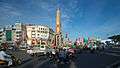 The Monument in downtown Cà Mau City, surrounded with the Provincial Administrative Hall, the Central Post Office and several banks
 Phan Ngọc Hiển street in Cà Mau Central
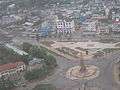 Cà Mau city downtown viewed from the air
 A main street in Cà Mau city
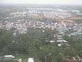 Cà Mau city
References
- Nghị quyết số 24/NQ-CP ngày 04 tháng 6 năm 2009 của Chính phủ Việt Nam.
- "Thành phố Cà Mau". Ủy ban Nhân dân Thành phố Cà Mau (Cà Mau City People's Committee). Archived from the original on 14 October 2008.
- VietNamNet Bridge Archived 20 July 2006 at the Wayback Machine. English.vietnamnet.vn. Retrieved on 15 November 2011.
- Life. Nhan Dan. Retrieved on 15 November 2011.
- "Vietnam Building Code Natural Physical & Climatic Data for Construction" (PDF) (in Vietnamese). Vietnam Institute for Building Science and Technology. Archived from the original (PDF) on 22 July 2018. Retrieved 23 July 2018.
External links
| Wikimedia Commons has media related to Ca Mau City. |
| Cà Mau |  | |
|---|---|---|
| Cái Nước | ||
| Đầm Dơi | ||
| Năm Căn | ||
| Ngọc Hiển | ||
| Phú Tân | ||
| Thới Bình |
| |
| Trần Văn Thời | ||
| U Minh |
| |
| 2,000,000 and more |
|
|---|---|
| 1,000,000–1,999,999 | |
| 500,000–999,999 | |
| 200,000–499,999 | |