British Columbia Highway 7
Highway 7, known for most of its length as the Lougheed Highway and Broadway, is an alternative route to Highway 1 through the Lower Mainland region of British Columbia. Whereas the controlled-access Highway 1 follows the southern bank of the Fraser River, Highway 7 follows the northern bank.
| ||||
|---|---|---|---|---|
| Lougheed Highway Broadway Haney Bypass | ||||
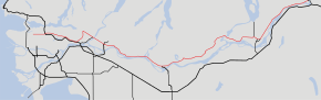 Sections in red denotes Highway 7 | ||||
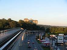
 Lougheed Highway near Coquitlam (2018) | ||||
| Route information | ||||
| Length | 150 km (90 mi) | |||
| Existed | 1941–present | |||
| Major junctions | ||||
| West end | ||||
Golden Ears Way in Maple Ridge | ||||
| East end | ||||
| Location | ||||
| Districts | Mission, Kent, Hope | |||
| Major cities | Vancouver, Burnaby, Coquitlam, Port Coquitlam, Pitt Meadows, Maple Ridge | |||
| Highway system | ||||
British Columbia provincial highways
| ||||

Highway 7 was first commissioned in 1941, and originally went from Vancouver to Harrison Hot Springs, following Dewdney Trunk Road between Port Moody and Port Coquitlam. In 1953, Highway 7 was moved to its current alignment between Vancouver and Coquitlam. Its eastern end was moved south from Harrison Hot Springs to Agassiz in 1956, and then east to Ruby Creek in 1968. Since 1973, Highway 7 has travelled to a junction with Highway 1 just north of Hope.
Unlike former Alberta premier Peter Lougheed's name, the name of the highway is pronounced /ˈloʊhiːd/ LOH-heed. The highway is named after Nelson Seymour Lougheed, MLA for the Dewdney District and the BC Minister of Public Works (1928–29) who ran a logging company in the area.
Route details
Highway 7's total length under the jurisdiction of the British Columbia Ministry of Transportation (MOT) is 118 km (73 mi). Highway 7 is signed as far west as Granville Street on Broadway in Vancouver, all the way east through Burnaby into Coquitlam, which is under the jurisdiction of the South Coast British Columbia Transportation Authority (TransLink). The section under the MOT's jurisdiction begins at the westbound exit with Highway 1 near Schoolhouse Street, with a total length of 2.3 km (1.4 mi). The highway then turns immediately northeast, meets with Highway 1 at the Cape Horn Interchange, and has an exit with United Boulevard. The highway leaves the MOT's jurisdiction 300 m (1000 ft) after the interchange.[1] TransLink again has jurisdiction of Highway 7 from the point east of Ottawa Street to the point east of United Boulevard.[2]
Highway 7 falls under the MOT's jurisdiction again after Ottawa Street, crossing over the Pitt River Bridge into Pitt Meadows. 6 km (4 mi) southeast of the Pitt River bridge, it crosses into Maple Ridge at Maple Meadows Way, and the highway then crosses into Mission another 20 km (12 mi) east. 9 km (6 mi) of Highway 7's entry into Mission, it meets a junction with Highway 11. 8 km (5 mi) east of the Highway 11 junction, Highway 7 leaves Mission over the Hatzic Pump Bridge.
27 km (17 mi) east of the Highway's eastern exit from Mission, Highway 7 enters the Municipality of Kent. 14 km (9 mi) east, it reaches a junction with Highway 9 at Agassiz. 18 km (11 mi) northeast of the Highway 9 junction, it leaves Kent. Another 12 km (7 mi) northeast, Highway 7 finally reaches its eastern terminus at a junction with Highway 1 at Haig, just across the Fraser River from the main part of Hope.
Major intersections
From west to east:
| Regional district | Location | km[3] | mi | Destinations | Notes | ||
|---|---|---|---|---|---|---|---|
| Broadway continues west | |||||||
| Metro Vancouver | Vancouver | 0.00 | 0.00 | Western Terminus of Hwy 7 | |||
| 0.85 | 0.53 | Oak Street | Alternate route to Hwy 99 south | ||||
| 1.70 | 1.06 | ||||||
| 2.70 | 1.68 | Main Street – City Centre | |||||
| 2.80 | 1.74 | Kingsway | Former Hwy 1A / Hwy 99A | ||||
| 4.40 | 2.73 | Clark Drive | Connects to Knight Street | ||||
| 5.00 | 3.11 | ||||||
| 6.00 | 3.73 | Nanaimo St | |||||
| 6.90 | 4.29 | Renfrew St | |||||
| 7.60 | 4.72 | Rupert Street | Eastern terminus of Broadway; Hwy 7 becomes Lougheed Highway | ||||
| ↑ / ↓ | 8.50 | 5.28 | Boundary Road | ||||
| Burnaby | 10.00 | 6.21 | |||||
| 11.60 | 7.21 | ||||||
| 12.70 | 7.89 | Kensington Avenue | Grade separated; eastbound exit and entrance | ||||
| 12.90 | 8.02 | Provides access to Winston Avenue and Kensington Avenue | |||||
| 15.00 | 9.32 | ||||||
| 16.40 | 10.19 | ||||||
| 16.90 | 10.50 | Gaglardi Way – Simon Fraser University | |||||
| ↑ / ↓ | 18.50 | 11.50 | North Road – New Westminster, Pattullo Bridge | ||||
| Coquitlam | 20.30 | 12.61 | Brunette Avenue – New Westminster, Pattullo Bridge | No right turn from Lougheed Hwy or left turn from Brunette Ave. | |||
| 23.20 | 14.42 | Cape Horn Interchange No access from Hwy 7 east to Hwy 1 west; Hwy 7 turns north | |||||
| 24.50 | 15.22 | United Boulevard | Partially grade-separated; westbound access to Hwy 7B | ||||
| 29.60 | 18.39 | Barnet Highway Pinetree Way – Coquitlam City Centre | Hwy 7 branches east; former Hwy 7A west | ||||
| Port Coquitlam | 33.10 | 20.57 | Coast Meridian Road | Partially grade separated | |||
| 33.80 | 21.00 | Ottawa Street | |||||
| East end of TransLink jurisdiction[4] | |||||||
| 34.80 | 21.62 | Interchange | |||||
| ↑ / ↓ | 35.40 | 22.00 | Pitt River Bridge crosses the Pitt River | ||||
| Pitt Meadows | 36.28 | 22.54 | Old Dewdney Trunk Road, Kennedy Road | ||||
| 38.84 | 24.13 | Harris Road | |||||
| 40.56 | 25.20 | Partially grade separated; Hwy 916 is unsigned | |||||
| Maple Ridge | 40.99 | 25.47 | Dewdney Trunk Road, Maple Meadows Way | Entrance from Golden Ears Way north | |||
| 45.22 | 28.10 | 222 Street, Haney Bypass Lougheed Highway | Hwy 7 follows Haney Bypass | ||||
| 47.78 | 29.69 | Lougheed Highway Kanaka Way | Hwy 7 returns to Lougheed Hwy | ||||
| Fraser Valley | Mission | 69.46 | 43.16 | ||||
| 70.51 | 43.81 | West end of one-way road pair | |||||
| 71.21 | 44.25 | Horne Street | Eastbound access to Horne Street Connector | ||||
| 71.34 | 44.33 | Hwy 915:0671 is unsigned; connects to Horne Street Connector; no direct eastbound access | |||||
| 72.64 | 45.14 | East end of one-way road pair | |||||
| Kent | 103.90 | 64.56 | Harrison River Bridge crosses the Harrison River | ||||
| 118.42 | 73.58 | Hwy 7 turns right; west end of Hwy 9 concurrency | |||||
| 120.01 | 74.57 | East end of Hwy 9 concurrency | |||||
| 121.61 | 75.56 | Agassiz Interchange Hwy 915:2752 is unsigned; westbound exit, eastbound entrance | |||||
| Hope | 150.44 | 93.48 | Haig Interchange Eastern terminus of Hwy 7 | ||||
1.000 mi = 1.609 km; 1.000 km = 0.621 mi
| |||||||
References
- "Coquitlam council asks for better signage after drivers cross Port Mann Bridge by mistake". Vancouver Sun.
- "Official Numbered Routes in British Columbia". B.C. Ministry of Transportation. Archived from the original on 2018-07-14. Retrieved 2018-05-19.
- Landmark Kilometre Inventory (PDF). British Columbia Ministry of Transportation and Infrastructure (Report). Cypher Consulting. July 2016. pp. 192–200. Archived from the original (PDF) on 2017-03-11. Retrieved 2017-03-11.
- Major Road Network (PDF) (Map). TransLink. May 20, 2016. Retrieved March 2, 2017.