Hastings Street (Vancouver)
Hastings Street is one of the most important east-west traffic corridors in the cities of Vancouver and Burnaby, British Columbia, Canada,[2] and used to be a part of the decommissioned Highway 7A. In the central business district of Downtown Vancouver it is known as West Hastings Street; at Carrall Street it becomes East Hastings Street and runs eastwards through East Vancouver and Burnaby. In Burnaby, there is no east-west designation. The street ends in Westridge, a neighbourhood at the foot of Burnaby Mountain where it joins the recently built Burnaby Mountain Parkway and diverges from the continuation of the former Highway 7A as the Barnet Highway, to Port Moody, British Columbia.
 Circa 1945. Looking northwest towards the Marine Building from Granville Street. | |
| Part of | |
|---|---|
| Namesake | George Fowler Hastings |
| Length | 13.4 km[1] (8.3 mi) |
| Location | Vancouver, Burnaby, British Columbia, Canada |
| Nearest metro station | Waterfront station |
| West end | Cardero Street |
| Major junctions | Granville Street Main Street Barnet Highway |
| East end | Burnaby Mountain Parkway |
Route description
Formally named in 1885 for Rear-Admiral George Fowler Hastings of the Royal Navy,[3] the street runs past such well-known Vancouver landmarks as the Marine Building, the Vancouver Club, Sinclair Centre, Harbour Centre (once Spencer's, Eaton's, then Sears and now the downtown campus of Simon Fraser University), Dominion Building and Victory Square (the location of the city's original courthouse) and the Woodward's building; located in the old Dunn's Tailors building at Homer and West Hastings is the campus of the Vancouver Film School, while on the corner of Cambie is the Carter-Cotton Building, the former headquarters of the Vancouver Province newspaper. East of Woodward's, the street forms the heart of Vancouver's historic original downtown, once known as the Great White Way because of its neon displays, and which is today the troubled Downtown Eastside and a notorious open-air drug market. Through the East End, after a stretch of warehouse-type commercial and wholesale businesses, the street forms one of the commercial cores for Vancouver's Italian community in a mixed-ethnicity retail area in the area of Nanaimo Street, just east of which the Pacific National Exhibition and Playland are on the city of Vancouver's eastern fringe. After leaving Vancouver, Hastings forms the core of a Burnaby retail neighbourhood known as the Heights and then traverses Capitol Hill to the Lochdale and Westridge areas.
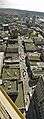
Photos
 West Hastings, looking east from Harbour Centre.
 100 Block East Hastings Street (North side) near Columbia Street
 200 Block East Hastings Street (North side) near Main Street, Downtown Eastside, Vancouver.
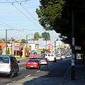 East Hastings Street, Vancouver. Looking east from Victoria Drive.
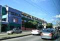 East Hastings Street in East Vancouver, between Cassiar St. and Skeena St.
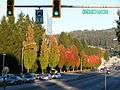
 Hastings Street joins Inlet Drive (on the left) while continuing uphill towards Simon Fraser University. Eagle Ridge and Westridge in the distance.
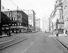
.jpg) 1911 view of West Hastings, looking eastward from the corner of Granville Street.
1911 view of West Hastings, looking eastward from the corner of Granville Street..jpg) View looking westward from Cambie Street March 1, 1912. Probably taken from an upper floor or the roof of the Carter-Cotton Building.
View looking westward from Cambie Street March 1, 1912. Probably taken from an upper floor or the roof of the Carter-Cotton Building.
References
- Google (December 28, 2016). "Hastings Street in Vancouver and Burnaby" (Map). Google Maps. Google. Retrieved December 28, 2016.
- "101 West Hastings Street: Urban Design Guidelines Administrative Report, City of Vancouver, April 6, 2004". Archived from the original on September 30, 2007. Retrieved February 2, 2007.
- Snyders, Tom. Namely Vancouver. 2001. Arsenal Pulp Press.