Agassiz, British Columbia
Agassiz (/ˈæɡəsi/ AG-ə-see)[1] is a small community located in the Eastern Fraser Valley region of British Columbia, Canada, about 97 kilometres east of Vancouver and immediately north of the city of Chilliwack.[2] The only town within the jurisdiction of the District Municipality of Kent, it contains the majority of Kent's population.
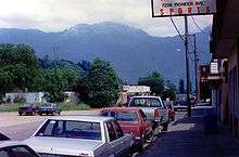
A view of the mountains from Agassiz, BC.
Climate
| Climate data for Agassiz, British Columbia | |||||||||||||
|---|---|---|---|---|---|---|---|---|---|---|---|---|---|
| Month | Jan | Feb | Mar | Apr | May | Jun | Jul | Aug | Sep | Oct | Nov | Dec | Year |
| Record high °C (°F) | 17.2 (63.0) |
21.7 (71.1) |
25.8 (78.4) |
32.2 (90.0) |
36.0 (96.8) |
36.7 (98.1) |
38.3 (100.9) |
39.4 (102.9) |
35.6 (96.1) |
28.3 (82.9) |
21.1 (70.0) |
17.2 (63.0) |
39.4 (102.9) |
| Average high °C (°F) | 6.2 (43.2) |
8.5 (47.3) |
11.6 (52.9) |
15.0 (59.0) |
18.5 (65.3) |
21.1 (70.0) |
24.0 (75.2) |
24.6 (76.3) |
21.3 (70.3) |
15.0 (59.0) |
8.9 (48.0) |
5.8 (42.4) |
15.0 (59.0) |
| Daily mean °C (°F) | 3.4 (38.1) |
5.1 (41.2) |
7.5 (45.5) |
10.4 (50.7) |
13.6 (56.5) |
16.2 (61.2) |
18.5 (65.3) |
18.7 (65.7) |
15.9 (60.6) |
11.0 (51.8) |
6.1 (43.0) |
3.2 (37.8) |
10.8 (51.4) |
| Average low °C (°F) | 0.5 (32.9) |
1.6 (34.9) |
3.4 (38.1) |
5.6 (42.1) |
8.8 (47.8) |
11.3 (52.3) |
12.8 (55.0) |
12.8 (55.0) |
10.3 (50.5) |
6.9 (44.4) |
3.2 (37.8) |
0.5 (32.9) |
6.5 (43.7) |
| Record low °C (°F) | −25.0 (−13.0) |
−24.4 (−11.9) |
−14.4 (6.1) |
−3.9 (25.0) |
−1.1 (30.0) |
1.7 (35.1) |
3.3 (37.9) |
1.7 (35.1) |
−1.1 (30.0) |
−8.5 (16.7) |
−19.0 (−2.2) |
−21.1 (−6.0) |
−25.0 (−13.0) |
| Average precipitation mm (inches) | 240.8 (9.48) |
142.1 (5.59) |
154.7 (6.09) |
125.9 (4.96) |
103.0 (4.06) |
92.2 (3.63) |
66.6 (2.62) |
58.2 (2.29) |
87.6 (3.45) |
191.7 (7.55) |
285.0 (11.22) |
206.1 (8.11) |
1,754.1 (69.06) |
| Average rainfall mm (inches) | 220.8 (8.69) |
131.1 (5.16) |
148.8 (5.86) |
125.5 (4.94) |
103.0 (4.06) |
92.2 (3.63) |
66.6 (2.62) |
58.2 (2.29) |
87.6 (3.45) |
191.6 (7.54) |
275.8 (10.86) |
187.7 (7.39) |
1,688.9 (66.49) |
| Average snowfall cm (inches) | 20.3 (8.0) |
12.5 (4.9) |
5.8 (2.3) |
0.4 (0.2) |
0 (0) |
0 (0) |
0 (0) |
0 (0) |
0 (0) |
0.2 (0.1) |
9.2 (3.6) |
19.0 (7.5) |
67.4 (26.6) |
| Average precipitation days (≥ 0.2 mm) | 19.2 | 17.3 | 19.9 | 17.8 | 17.1 | 15.0 | 10.4 | 10.1 | 11.7 | 17.1 | 21.3 | 20.0 | 196.9 |
| Average rainy days (≥ 0.2 mm) | 16.8 | 15.8 | 19.6 | 17.8 | 17.1 | 15.0 | 10.4 | 10.1 | 11.7 | 17.1 | 20.7 | 18.1 | 190.1 |
| Average snowy days (≥ 0.2 cm) | 4.6 | 2.8 | 1.0 | 0.2 | 0 | 0 | 0 | 0 | 0 | 0.07 | 1.3 | 3.9 | 13.87 |
| Mean monthly sunshine hours | 57.8 | 85.7 | 127.7 | 163.9 | 194.2 | 195.6 | 255.8 | 242.2 | 196.8 | 122.2 | 60.2 | 53.6 | 1,755.6 |
| Source: Environment Canada[3] | |||||||||||||
History
The land on the Fraser that is now called Agassiz was once the location of villages of the First Nation Steaten people that had been wiped out by the disease starting in 1782.[4] Later another village of former First Nation slaves settled there called Freedom Village (Halkomelem: Chi'ckim).[4]
Government and infrastructure
Correctional Service of Canada (CSC) Kent Institution is in Agassiz.
Gallery
 The Agassiz-Harrison Museum
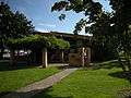 District of Kent District Hall and Public Library, Agassiz, BC.
See also
References
- The Canadian Press (2017), The Canadian Press Stylebook (18th ed.), Toronto: The Canadian Press)
- "Agassiz (Community)". BC Geographical Names.
- "Canadian Climate Normals 1981-2010 at station AGASSIZ CDA". Environment Canada. 2013-07-01. Retrieved 2014-01-02.
- Carlson 2010, p. 142.
- Carlson, Keith Thor (2010). The Power of Place, the Problem of Time: Aboriginal Identity and Historical Consciousness in the Cauldron of Colonialism. University of Toronto Press. ISBN 9781442699960.CS1 maint: ref=harv (link) - Total pages: 368
| Wikimedia Commons has media related to Agassiz, British Columbia. |
| Subdivisions |  | |
|---|---|---|
| Communities | ||
| Metro areas and agglomerations |
| |
| Detached communities within district municipalities |
| |
| ||
This article is issued from Wikipedia. The text is licensed under Creative Commons - Attribution - Sharealike. Additional terms may apply for the media files.