Bozkurt, Kastamonu
Bozkurt is a town and district of the Kastamonu Province in the Black Sea region of Turkey. According to the 2010 census, population of the district is 8,945 of which 5,074 live in the town of Bozkurt.[3][4] The district covers an area of 286 km2 (110 sq mi),[5] and the town lies at an elevation of 239 m (784 ft).
Bozkurt | |
|---|---|
District | |
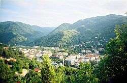 A panorama of Bozkurt | |
 Location of Bozkurt within Turkey. | |
 Bozkurt Location of Bozkurt | |
| Coordinates: 41°57′N 34°01′E | |
| Country | |
| Region | Black Sea |
| Province | Kastamonu |
| Government | |
| • Mayor | Engin Canbaz (AKP) |
| • Governor | Uhut Emre KOYUNCU |
| Area | |
| • District | 286.12 km2 (110.47 sq mi) |
| Elevation | 239 m (784 ft) |
| Population (2012)[2] | |
| • Urban | 5,191 |
| • District | 8,946 |
| • District density | 31/km2 (81/sq mi) |
| Time zone | UTC+2 (EET) |
| • Summer (DST) | UTC+3 (EEST) |
| Postal code | 37xxx |
| Area code(s) | 366 |
| Licence plate | 37 |
| Climate | Cfa |
| Website | www.kastamonubozkurt.bel.tr |
Villages
The district's villages are Alantepe, Ambarcılar, Bayramgazi, Beldeğirmeni, Çiçekyayla, Darsu, Dursun, Görentaş, Günvakti, Güngören, Işığan, İbrahim, İnceyazı, Kayalar, Kestanesökü, Keşlik, Kızılcaelma, Kirazsökü, Koşmapınar, Köseali, Kutluca, Mamatlar, Ortasökü, Sakızcılar, Sarıçiçek, Şeyhoğlu, Tezcan, Ulu, Yakaören (İlişi), Yaşarlı and Yaylatepe.
Image gallery
 War memorial and cemetery
 Municipality building
Notes
- "Area of regions (including lakes), km²". Regional Statistics Database. Turkish Statistical Institute. 2002. Retrieved 2013-03-05.
- "Population of province/district centers and towns/villages by districts - 2012". Address Based Population Registration System (ABPRS) Database. Turkish Statistical Institute. Retrieved 2013-02-27.
- Statistical Institute
- GeoHive. "Statistical information on Turkey's administrative units". Retrieved 2008-11-23.
- Statoids. "Statistical information on districts of Turkey". Retrieved 2008-11-23.
References
- Falling Rain Genomics, Inc. "Geographical information on Bozkurt, Turkey". Retrieved 2008-11-08.
External links
- District governor's official website (in Turkish)
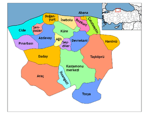
Bozkurt, Kastamonu in Kastamonu Province of Turkey | |||||||||||||||||||||||||||
|---|---|---|---|---|---|---|---|---|---|---|---|---|---|---|---|---|---|---|---|---|---|---|---|---|---|---|---|
| Districts | Districts of Kastamonu | ||||||||||||||||||||||||||
| |||||||||||||||||||||||||||
Metropolitan municipalities are bolded. | |||||||||||||||||||||||||||
This article is issued from Wikipedia. The text is licensed under Creative Commons - Attribution - Sharealike. Additional terms may apply for the media files.