Ağlı
Ağlı (IPA: [ˈaːɫɯ]) is a town and district of the Kastamonu Province in the Black Sea region of Turkey. According to the 2000 census, population of the district is 4,193 of which 3,074 live in the town of Ağlı.[3] The district covers an area of 176 km2 (68 sq mi),[4] and the town lies at an elevation of 1,240 m (4,068 ft).
Ağlı | |
|---|---|
District | |
 Location of Ağlı within Turkey. | |
 Ağlı Location of Ağlı | |
| Coordinates: 41°43′N 33°33′E | |
| Country | |
| Region | Black Sea |
| Province | Kastamonu |
| Government | |
| • Mayor | Şahin Çolak (MHP) |
| Area | |
| • District | 175.79 km2 (67.87 sq mi) |
| Elevation | 1,240 m (4,070 ft) |
| Population (2012)[2] | |
| • Urban | 1,913 |
| • District | 2,863 |
| • District density | 16/km2 (42/sq mi) |
| Time zone | UTC+2 (EET) |
| • Summer (DST) | UTC+3 (EEST) |
| Postal code | 37920 |
| Area code(s) | 366 |
| Licence plate | 37 |
| Climate | Cfb |
| Website | www www |
History[5]
The history of Ağlı descends to the depths of the First Age, with no definite evidence at hand. Findings from this period indicate that various civilizations have come and gone on these lands. B.C. It is known that between 1100-700 Kastamonu and its surrounding Paflagans were ruled. The history of Kastamonu shows that the tribes such as Byzantines, Danishmenders, Shepherds and Candaros ruled in and around Ağlı. It has been under the Byzantine rule for a long time. The most important work that has come to this day is Ağal Kalesidir. Kastamonu and its surroundings also participated in the Ottoman Empire after İsmail Bey did not resist Fatih and gave up his sovereignty rights in order to prevent his sister from casting. A municipal organization was established in 1918. According to the Law No. 3644, which was adopted on May 9, 1990 and entered into force on May 20, 1990, it became a district.
Notes
- "Area of regions (including lakes), km²". Regional Statistics Database. Turkish Statistical Institute. 2002. Retrieved 2013-03-05.
- "Population of province/district centers and towns/villages by districts - 2012". Address Based Population Registration System (ABPRS) Database. Turkish Statistical Institute. Retrieved 2013-02-27.
- Turkish Statistical Institute. "Census 2000, Key statistics for urban areas of Turkey" (in Turkish). Archived from the original (XLS) on July 22, 2007. Retrieved November 10, 2008.
- Statoids. "Statistical information on districts of Turkey". Archived from the original on May 26, 2010. Retrieved November 22, 2008.
- Turkish Ministry of Culture and Tourism. "Ağlı" (XLS) (in Turkish). Retrieved July 23, 2018.
References
- Falling Rain Genomics, Inc. "Geographical information on Ağlı, Turkey". Retrieved 2008-11-10.
External links
- District governor's official website (in Turkish)
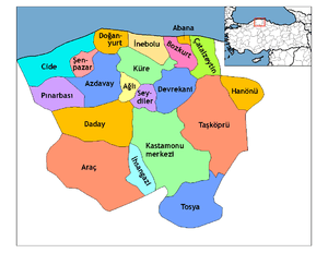
Ağlı in Kastamonu Province of Turkey | |||||||||||||||||||||||||||
|---|---|---|---|---|---|---|---|---|---|---|---|---|---|---|---|---|---|---|---|---|---|---|---|---|---|---|---|
| Districts | Districts of Kastamonu | ||||||||||||||||||||||||||
| |||||||||||||||||||||||||||
Metropolitan municipalities are bolded. | |||||||||||||||||||||||||||