Albury, Surrey
Albury is a village and civil parish in the borough of Guildford in Surrey, England, about 4 miles (6.4 km) south-east of Guildford town centre. The village is within the Surrey Hills Area of Outstanding Natural Beauty. Farley Green, Little London and adjacent Brook form part of the civil parish.
| Albury | |
|---|---|
| Village | |
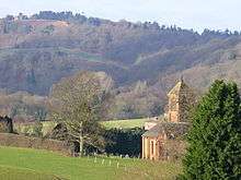
 Albury village | |
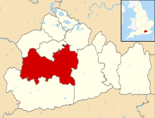
 Albury Location within Surrey | |
| Area | 16.28 km2 (6.29 sq mi) |
| Population | 1,191 (Civil Parish 2011)[1] |
| • Density | 73/km2 (190/sq mi) |
| OS grid reference | TQ0447 |
| Shire county | |
| Region | |
| Country | England |
| Sovereign state | United Kingdom |
| Post town | Guildford |
| Postcode district | GU5 |
| Dialling code | 01483 |
| Police | Surrey |
| Fire | Surrey |
| Ambulance | South East Coast |
| UK Parliament | |
Geography and economy
Albury civil parish spans the small village and three hamlets, which are Farley Green, Little London and adjacent Brook – spaced out by Albury Heath, Foxholes Wood, small fields and Albury Park. About a third of Blackheath Common on the Greensand Ridge is in the parish, which centrally nestles in the 'Vale of Holmesdale'. The old village lay within what is now Albury Park. Albury new village is at the point where the Sherborne, flowing from near Newlands Corner via the Silent Pool, joins the Tillingbourne that runs through the centre of the village and until the 20th century powered Albury flour mill at the Chilworth edge of the village. The mill is now converted into offices and apartments. There is another watercourse leading into the Tillingbourne at Chilworth, the Law Brook, which the hamlet of Brook is centred on.
The 66 acres (27 ha) of Colyers Hanger SSSI, an area of ancient woodland, is in the parish of Albury.[2]
According to the 2011 Census, the population was 1,191.[1] This was an increase of one since 2001 when the population lived in 527 homes (52 of which had their lowest floor level above street level and 298 of which were owner-occupied). While 583 people were economically active: 372 commuted by motor vehicle and 61 commuted by public transport, the average Albury commuter travelled 17 kilometres (11 mi).[3]
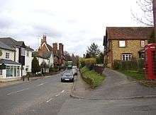
The village has a post office and general shop, and the Drummond at Albury inn; Little London has another public house the William IV.
The nearest railway stations are just beyond the borders: Chilworth, 1 mile (1.6 km) west, and Gomshall, 2 miles (3.2 km) east, of the parish boundaries, both on the North Downs Line.
History

The name “Albury” derives from the Old English ald (old) and burh (fortification).[4]
Farley Heath in the southwest of the parish has remains of a Romano-Celtic temple within a temenos in a clearing by Heath Road containing an inner cella, nearby a pottery kiln and tumbled columns can be seen.[5][6]
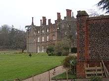
The village appears in the Domesday Book as Eldeberie. It was held by Roger d'Abernon from Richard de Tonebrige. Its Domesday Assets were: 2½ hides, 1 church, 1 mill worth 5s, 8½ ploughs, 1-acre (4,000 m2) of meadow, woodland worth 30 hogs. It rendered £9.[7] Albury village is next to Albury Estate which is an estate of 150 acres (0.61 km2). Within it is the Saxon church, the Mansion or Albury Park House, a Grade II* listed building.[8] (now a retirement home), and a few surviving houses of the old village. In 1842, Henry Drummond moved the rest of the village half a mile westward to what was originally the hamlet of Weston Street, where he also built a new church.[9] The Duke of Northumberland owns the estate – the Mansion was once home to the Duke and Duchess. The gardens are designated Grade I[10] and were designed by author and gardener John Evelyn whose family home was nearby at Wotton, 6 miles (9.7 km) to the east.
The William IV public house in close-by Little London dates back to the 16th century.[11]
Sports
Fishing is available in the stocked Albury Estate ponds at Weston, Vale End, Albury Park and at Powder Mills, Chilworth with the Albury Estate Fisheries club.
Albury Cricket Club play at the Albury Heath ground that adjoins Albury Eagles FC, close to Albury and to Little London in Sandy Lane, the clubs have a combined social events calendar. The football club has several U16, U13 and U9 teams.[12]
Churches
The parish of Albury has four churches:
- The parish church of St Peter and St Paul,[13] built 1842 by McIntosh Brooks, transept and apse added 1868 by Sir Arthur Blomfield; north chapel created by neo-gothicist Sir Edward Maufe, designer of Guildford Cathedral.
- The Barn church, St Michael's in Farley Green
- Old St Peter and St Paul's Church, a church of Saxon origin with 12th-century tower, 13th-century chancel, 14th-century nave and 16th-century north porch, Drummond Chapel (with marble chest tomb) and south window with quatrefoil renewed by Pugin: in Albury Park in the care of the Churches Conservation Trust, a Grade I listed building.[14]
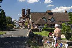
- The Catholic Apostolic Church graded II*, also built by McIntosh Brooks,[15] is by the Sherbourne brook at the northeast end of the village street near to where it joins the A25.
Demography and housing
| Output area | Detached | Semi -detached | Terraced | Flats and apartments | Caravans mobile homes | Shared housing |
|---|---|---|---|---|---|---|
| (Civil Parish) | 235 | 134 | 56 | 51 | 3 | 0 |
The average level of accommodation in the region composed of detached houses was 28%, the average which were apartments was 22.6%.
| Output area | Population | Households | Owned outright | Owned with a loan | hectares |
|---|---|---|---|---|---|
| (Civil Parish) | 1,191 | 479 | 34.2% | 27.1% | 1,628 |
The proportion of households in the civil parish who owned their home outright compares to the regional average of 35.1%. The proportion who owned their home with a loan compares to the regional average of 32.5%. The remaining % is made up of rented dwellings (plus a negligible % of households living rent-free).
Albury landfill
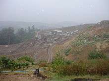
Albury has one of the two active landfill sites in Surrey; it only takes household waste. There is a landfill liaison committee in existence which has been organised to work with the operator, SITA to keep the villagers aware of all issues. This landfill generates revenue for Albury Estate. Residents of the village suffer little if any effects, being generally more than 1 mile (1.6 km) from it, however the parish council expressed discontent to the borough council when permission was granted for the use in the Surrey Hills Area of Outstanding Natural Beauty and will work with the estate to ensure complete restoration of the entire landscape when operations cease.[16]
References
- Key Statistics; Quick Statistics: Population Density United Kingdom Census 2011 Office for National Statistics Retrieved 21 November 2013
- "The citation of the SSSI in the parish" (PDF). Natural England – SSSI body. Archived from the original (PDF) on 24 October 2012. Retrieved 7 May 2012.
- "2001 Census". ONS. Retrieved 7 May 2012.
- Field, John (1980). Place-names of Great Britain and Ireland. Newton Abbot, Devon: David & Charles. p. 22. ISBN 0389201545. OCLC 6964610.
- Romano-Celtic temple: Historic England. "Details from listed building database (1005941)". National Heritage List for England. Retrieved 7 May 2012.
- "Details of Farley Heath temple". Roman Britain. Archived from the original on 3 June 2012. Retrieved 7 May 2012.
- Surrey Domesday Book Archived 30 October 2007 at the Wayback Machine
- Historic England. "Details from listed building database (1029565)". National Heritage List for England. Retrieved 7 May 2012.
- 'Parishes: Albury', in A History of the County of Surrey: Volume 3, ed. H E Malden (London, 1911), pp. 72-77. British History Online http://www.british-history.ac.uk/vch/surrey/vol3/pp72-77 [accessed 24 August 2018].
- Historic England. "Details from listed building database (1000299)". National Heritage List for England. Retrieved 7 May 2012.
- Historic England. "Details from listed building database (1377783)". National Heritage List for England. Retrieved 7 May 2012.
- "Albury Eagles". Archived from the original on 3 April 2012. Retrieved 7 May 2012.
- Historic England. "Details from listed building database (1029561)". National Heritage List for England. Retrieved 7 May 2012.
- Historic England. "Details from listed building database (1294958)". National Heritage List for England. Retrieved 7 May 2012.
- Historic England. "Details from listed building database (1029568)". National Heritage List for England. Retrieved 7 May 2012.
- Albury Parish Council Retrieved 21 November 2013
External links
| Wikimedia Commons has media related to Albury, Surrey. |
- Albury Parish Council
- Albury History
- Albury History Society
- Albury website
- Albury in the Domesday Book
- Surrey County Council. "Albury". Exploring Surrey's Past. Retrieved 11 January 2017.
Nearest Settlements | ||||||||||
|---|---|---|---|---|---|---|---|---|---|---|
| ||||||||||
| Authority control |
|
|---|