Burpham, Surrey
Burpham /ˈbɜːrfəm/[3] is a suburb of Guildford, a town in Surrey, England[4] with an historic village centre. It includes George Abbot School, a parade of small shops, and the nationally recognised Sutherland Memorial Park.
| Burpham | |
|---|---|
| Suburb | |
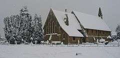 St Luke's Church, Burpham in snow with part of the Sutherland Memorial Park | |
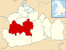
 Burpham Location within Surrey | |
| Population | 5,221 [1] 5,695 (2011. Ward)[2] |
| OS grid reference | TQ015518 |
| District | |
| Shire county | |
| Region | |
| Country | England |
| Sovereign state | United Kingdom |
| Post town | Guildford |
| Postcode district | GU1, GU4 |
| Dialling code | 01483 |
| Police | Surrey |
| Fire | Surrey |
| Ambulance | South East Coast |
- There is also a Burpham in West Sussex, England near Arundel
Burpham is bordered by the neighbourhoods of Merrow to the south-east and Jacobs Well to the north-west. Burpham is separated from Merrow by the New Guildford Line, the railway line between Guildford and Effingham Junction.
History
Burpham appears in Domesday Book as Borham. It was held partly by Turald (Thorold) from Roger de Montgomery and by Godfric from Thurold. Its domesday assets were: 3 hides; one mill worth 15s, 6½ ploughs, 25 acres (10 ha) of meadow, woodland worth 83 hogs. It rendered £8.[5][6]
It was, until the consecration of its church, known as the manor of Burpham or Burgham[7] in Worplesdon[8] Its owner in the 13th century was Thurstan le Despenser and it then passed through the de Wintershull (by release), Bassett, Unwyn, Wolley, Mainwaring, and finally Wyrley families by relatives. By marriage its owner became Robert Wroth, MP for Guildford in 1704, 1707 and 1714, who died in 1720.[9]
From 1720 the owner of the Manor was Baron Onslow,[7] whose title was elevated to an Earldom from a Barony in the early nineteenth century and who were frequent MPs for Guildford.
Lilac Cottage, co-listed with New Inn Farmhouse, a 17th-century building on London Road with modern extensions[10] and Pimms Row[11] are the listed buildings in the area, with two more in Abbotswood.
Amenities and places of worship
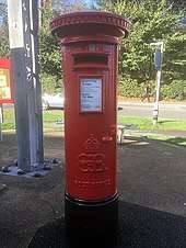
Within its bounds are a Sainsbury's superstore, the Surrey County Cricket Centre, two Church of England churches, a police station, a council offices building, a long parade of shops on London Road, a pub, the Anchor and Horseshoes, and in its eastern straight border woodland and to the north-east the working farm of Gosden Hill Farm, partly in the Clandon civil parish and village. The shopping parade incorporates a rare Edward VIII pillar box.
St Luke's Church
The Church of St Luke is a Grade II listed building.[12] The church is an ornate nineteenth century work built in 1859 designed by Henry Woodyer[12] fronting the northwest of Sutherland Memorial Park and by a primary school. The war memorial, in front of the church, is also Grade II listed.[13]
Holy Spirit Church
This is a second Church of England church, known locally as "CHS", serving the parishioners alongside St Luke's. The 1960s building is an unusual structure, with a cross-shaped floorplan, where laminated wooden beams at each corner define both walls and roof.[14]
Transport
Guildford's eastern-most junction with the A3 trunk road is named The Burpham Interchange, despite the fact that it is a restricted junction, only providing access for traffic heading to or from the London direction.
Burpham is on several bus routes that start or finish in Guildford. Routes 36 (Guildford - Burpham - Merrow - Guildford) and 37 (Guildford - Merrow - Burpham - Guildford), are circular routes both operated by Arriva, running at 20-minute intervals Monday to Saturday and hourly intervals on Sundays and Bank Holidays. Route 462, operated by White Bus Services between Guildford and Woking, join and leave the A3 at Burpham. Buses run bi-hourly Monday to Saturday, with No Sunday service. Additionally, Route 715 between Guildford and Kingston, operated by Stagecoach, runs the same route through Burpham as Route 462. This is an hourly service Monday to Friday, and bi-hourly on Sunday.
It is also a stop for some services heading to or from London on the A3.
Bowers Lock is a short distance from the village, on the River Wey Navigation.
Abbotswood
Abbotswood is the closest part of Burpham to Guildford and its only distinctively named neighbourhood. It comprises detached houses and the George Abbot School - it includes a road named Abbotswood and only a few other side roads off London Road such as Boxgrove Avenue; as with Burpham, within the post town of Guildford, directly north and east of the small roundabout north of Stoke Park. The land here ranges from a line of western drained fields at almost river level, named spreads, in flood times, marshland to ascending gentle slopes eastwards including the street Ganghill reaching towards the New Guildford Line railway. It has two listed buildings: Woodways[15] and Stoke Park Farm House.[16]
Sutherland Memorial Park
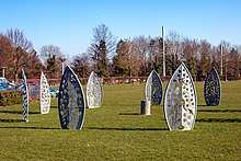
In the centre of the village is the Sutherland Memorial Park a 6.53-hectare (16.1-acre) open space which is a focus of community life in Burpham. The formal landscaped gardens provide for passive recreation alongside the many sporting facilities offered, and an area has been set aside and planted as a wildflower meadow.
The park was adopted by Guildford Corporation in 1954 after the land was donated by the Duke of Sutherland under a Deed of Gift. It was given as a dedicated War Memorial in memory of the residents of Burpham who were killed on active service during the Second World War. Adjoining land was developed and incorporated in the 1990s, including a car park.
The park won Green Flag Awards in 2004, 2005, 2006, 2014 and 2015, in recognition of its being "an excellent example of a community park as it addresses the needs and wishes of the local community and current users".[17][18]
The multi-use pavilion is home to a local nursery school, and provides changing and other facilities for the sports undertaken in the park. There are playgrounds for all ages, including a separate toddler area and a basketball court for the teenagers.
Sports facilities include: a cricket pitch (plus practice nets); two 11-a-side and two (junior) 7-a-side football pitches; two pétanque courts; lawn bowls; and a floodlit artificial pitch providing either three tennis courts or two 5-a-side football pitches.
The Park is the home ground of Burpham Football Club, who play in the Premier Division of the Surrey Elite Intermediate League.
The Green Man
The Green Man was a former coaching inn on the original A3 route from Guildford to London; a public house had been on the site for more than 400 years.[19] The Green Man had been a 'Harvester' restaurant since 1984,[19] but was sold for redevelopment early in 2006. A proposal that the former pub be demolished and replaced by an Aldi supermarket and residential dwellings was opposed by local residents.[19] However, the opposition was unsuccessful, and after Aldi removed the roofing tiles, leaving the building vulnerable to weather damage, demolition took place in December 2008. (Aldi had previously undertaken to not demolish the building until their planning application had been approved.[19]) Opposition by local residents continued, with the Residents' Association still campaigning for a public house on the site rather than a supermarket. Recently just under 90% of respondents to Aldi's latest planning application opposed the scheme. A majority of councillors, in a vote of 15 to five, agreed with the borough council's planning officer's recommendation to move forward with the store. Construction of the new Aldi supermarket commenced early 2015 and the new store opened on 5 November 2015.
Collisions on the A3
Several collisions per year occur on the section of the A3 dual carriage way that runs by the Burpham junction being a London and M25 south-west approach. On Wednesday 11 December 2002, several motorists telephoned to report that a car had veered off the A3. Dispatched officers found no sign of a newly crashed vehicle at the scene but did discover the wreckage of a Vauxhall Astra, containing the remains of a man, no more than 20 metres (66 ft) from the reported crash site. The car was buried in twisted undergrowth, nose-down in a ditch, invisible from the road. A police spokesman later said: "We believe the car left the road and ended up in the ditch during July. It doesn't appear that any other vehicles were involved. The car was discovered as a result of a report from members of the public who thought they saw a car's headlights veering off the road."[20][21]
Air accident
On 10 January 1954 a light aircraft attempted a forced landing in the fields behind the George Abbot School but clipped a row of trees and spun into the rear garden of the Anchor and Horseshoes pub on the London Road. Fortunately there were no casualties.[22]
Burpham Court Farm Park
Burpham Court Farm Park was a rare breeds centre occupying a former dairy farm on land between Burpham (specifically, north of the Wey Navigation cut to Burpham Lock) and Jacobs Well. Some of the farm buildings date back to 1600. The farm straddles the River Wey on land owned by the National Trust.[23]
Former farmer Bob Dearnley died after a spillage of rat poison on the morning of 28 May 2009. Several emergency personnel were also admitted to hospital. He had been served with an eviction notice having unsuccessfully contested a court case against the council, the land owner, been arrested for affray earlier in the week of his death and incurred very large debts.[23][24]
The farm house and adjacent cottages are now private dwellings.[25]
See also
- Guildford City F.C. – formerly Burpham F.C.
References
- Census data
- "Guildford Ward population 2011". Neighbourhood Statistics. Office for National Statistics. Retrieved 5 October 2016.
- BBC Pronouncing Dictionary of British Names
- OS Explorer map 145:Guildford and Farnham. Scale: 1:25 000. Publisher:Ordnance Survey – Southampton. ISBN 978 0319239261
- Surrey Domesday Book Archived 15 July 2007 at the Wayback Machine
- "Place: Burpham". (Map from geodata of Domesday Book of 1086). Domesday Map. Archived from the original on 13 March 2012. Retrieved 25 April 2011.
- British History, University of London & History of Parliament Trust - Parish of Worplesdon - see paras 6-9 under Manor
- Edward Wedlake Brayley, A Topographical History of Surrey, Vol. II London 1850 Free e-book
- From: 'Parishes: Worplesdon', A History of the County of Surrey: Volume 3 (1911), pp. 390-395. Date accessed: 13 June 2012.
- Historic England. "Details from listed building database (1377865)". National Heritage List for England. Retrieved 13 June 2012.
- Historic England. "Details from listed building database (1029300)". National Heritage List for England. Retrieved 13 June 2012.
- Historic England. "Details from listed building database (1029301)". National Heritage List for England. Retrieved 13 June 2012.
- Historic England. "Burpham War Memorial (1437602)". National Heritage List for England. Retrieved 3 February 2019.
- Burpham Churches website - details of Sunday services, pastoral work, etc
- Historic England. "Details from listed building database (1029340)". National Heritage List for England. Retrieved 13 June 2012.
- Historic England. "Details from listed building database (1119784)". National Heritage List for England. Retrieved 13 June 2012.
- Confirmation of award from Nov 2006 issue of 'About Guildford', newspaper published by Guildford Borough Council
- "Green Flag Award- The national standard for parks and green spaces". Retrieved 22 February 2007.
- "Report of the Borough Honorary Remembrancer for the Municipal Year 2006/07" (PDF). (2.19 MB),
Roger Marjoribanks, Hon. Remembrancer, Borough of Guildford (Accessed 3 May 2009) - http://www.dailymail.co.uk/news/article-151325/Did-drivers-ghostly-replay-death-crash.html
- https://www.telegraph.co.uk/news/uknews/1438583/Skeleton-found-five-months-after-crash.html
- Rose, David (2016). Guildford Pubs. Amberley. p. 52. ISBN 978-1-4456-5719-6.
- "Tests due in poison farmer case". BBC News. Retrieved 1 September 2018.
- "Man dies in farm 'chemical' alert". BBC News. Retrieved 1 September 2018.
- "Protecting The Future of Burpham Court Farm". The Guildford Dragon. Retrieved 1 September 2018.
External links
| Wikimedia Commons has media related to Burpham, Surrey. |
- Sutherland Memorial Park – Green Flag Award
- Sutherland Memorial Park – at Guildford Borough Council website
- Surrey County Council. "Burpham". Exploring Surrey's Past. Retrieved 30 May 2017.