North Downs
The North Downs are a ridge of chalk hills in south east England that stretch from Farnham in Surrey to the White Cliffs of Dover in Kent.[1] Westerham Heights, at the northern edge of the North Downs, near Bromley, South London, is the highest point in London at an elevation of 245 m (804 ft). The North Downs lie within two Areas of Outstanding Natural Beauty (AONBs), the Surrey Hills and the Kent Downs. The North Downs Way National Trail runs along the North Downs from Farnham to Dover.
| North Downs | |
|---|---|
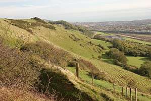 The North Downs near the entrance to the Channel Tunnel in Folkestone | |
| Location | England |
| Governing body | Kent Downs AONB, Surrey Hills AONB |
Etymology
'Downs' is from Old English dun, meaning, amongst other things, "hill". The word acquired the sense of "elevated rolling grassland" around the 14th century.[2] The name contains "North" to distinguish them from a similar range of hills – the South Downs – which runs roughly parallel to them but some 50 km (31 mi) to the south.
Geography


The narrow spine of the Hog's Back between Farnham and Guildford forms the western extremity of the North Downs, whilst the cliffs between Folkestone and Deal terminate the ridge in the east. There are two distinct aspects, the steep south-facing escarpment and the gentle north-facing dip slope. The southern boundary is defined by the foot of the escarpment which gives way to the flat, broad clay lands between the Downs and Greensand Ridge known as the Vale of Holmesdale. The northern boundary is less apparent but occurs where the chalk submerges below the more recent Paleocene deposits.[1]
The Downs are highest near the Kent–Surrey border, often reaching heights in excess of 200 m (660 ft) above sea level at the crest of the escarpment. The highest point is Botley Hill in Surrey at 269 m (883 ft).[3] The County top of Kent at Betsom's Hill, with a height of 251 m (823 ft) is located nearby,[4] and the highest point in Greater London, Westerham Heights, at 245 m (804 ft) is on the northern side of the same hill.[5] East of the Medway Valley the Downs become broader and flatter, extending as far as the Isle of Thanet.
The ridge is intersected by the valleys of a series of rivers: the Wey, Mole, Darent, Medway and Stour rivers. These drain much of the Weald to the south. The western rivers are tributaries of the Thames; they have carved steep valleys through the chalk and provide natural corridor routes. In addition to existing rivers, the Downs are crossed by a number of wind gaps – prehistoric river valleys no longer occupied by rivers – including those at Farnham, Betchworth, Caterham, Lyminge and Hawkinge. Except for the river valleys and wind gaps, the crest of the escarpment is almost continuous along its length. The dip slope is dissected by many small dry valleys, and in the broad eastern part in Kent, by further river valleys such as that of the Little Stour. Leith Hill is sometimes incorrectly referred to as part of the North Downs, but it is located on the parallel Greensand Ridge[6] and does not consist of chalk.
Geology
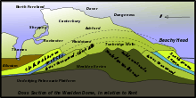
The Downland of the North Downs consists of distinct lithostratigraphic units (the types of strata, the names of which are always capitalised):
- The more level tops of the Downs are often covered by acidic strata, usually including a layer of Clay-with-Flints, a sandy clay with many flints, or various sands and gravels (these are not shown on the geological map and section in this article).
- The Chalk Group, composed almost entirely of chalk, a kind of soft fine-grained limestone. It is formed of three parts, the Upper Chalk, which has many flints, the Middle Chalk, with fewer flints, and the Lower Chalk or Coombe Rock, greyish, with few flints. The chalk is most commonly exposed on slopes or as cliffs, where the overlying acidic strata have been quarried or washed away. The buried upper surface of the chalk beneath the acidic strata is often eroded into pipes, gulleys and pinnacles, sometimes visible in road cuttings and quarries.
- The Upper Greensand Formation, a whitish, limy sandstone, often used for building, for which it has been mined from beneath the chalk (for example from the Godstone Baby Mines). The Upper Greensand of the North Downs is a thin bed of one or two metres thickness, and it is rarely visible at the surface (it is much thicker elsewhere).
The Upper Greensand marks the southern edge of the Downs, being underlain by:
- The Gault Formation of stiff blue clay.
- The Lower Greensand Formation of the Lower Cretaceous period, containing greensand, a glauconite sand or sandstone, as well as a certain amount of silts, clays, ironstone and limestone.
The topography of the North Downs mainly consists of the Chalk Group, the rock strata of the Upper Cretaceous period which in certain areas is overlain by superficial deposits of gravels or clay-with-flints.
Citing Dr D. T. Aldiss of the British Geological Survey:
The Greensand Ridge is separate from the Downs. Again, one has to be aware of the distinction between 'greensand' (typically glauconitic sand or sandstone; literally 'green sand') and 'the Greensand', a lithostratigraphic term which usually refers to the Lower Greensand Group (of Lower Cretaceous age). The Lower Greensand does contain some greensand, but also much silt, clay and limestone: most of it is neither green nor sand. It forms a distinct layer below the Gault Formation and the Upper Greensand Formation which directly underlie the Chalk Group. The 'Greensand Ridge' typically refers to one of a series of escarpments formed by the Lower Greensand. In Surrey, the Upper Greensand is thin and is not separately marked by rising ground, but elsewhere (in Sussex and Berkshire, for example) it too forms an escarpment. These groups and formations each occur in separate layers. In Surrey these dip northwards, generally at an angle of 2 degrees or less but increasing to as much as 55 degrees in the Hog's Back area, west of Guildford.
Ecology
The North Downs support several important habitats. The most distinctive of these is chalk grassland, which is largely limited to steep escarpment and valley slopes. This semi-natural habitat is maintained through sheep, cattle and rabbit grazing which prevents scrub encroachment. Chalk grassland to the west of the Medway Valley is dominated by upright brome (Bromus erectus) and fescue (Festuca) whilst grassland to the east is dominated by tor-grass (Brachypodium pinnatum).[1] Because of the close proximity of the North Downs to the European continent, the warm climate and the south facing escarpment, several plant species survive on the chalk grassland which are scarce or not found elsewhere in the British Isles.
The nationally rare late spider orchid (Ophrys fuciflora) is limited within the British Isles to chalk grassland between Folkestone and Wye. One of the two native British sites for the nationally rare monkey orchid (Orchis simia) is on the North Downs. The nationally scarce man orchid (Orchis anthropophora) is not uncommon on chalk grassland on the Downs in Surrey and Kent. Other scarce plant species such as early gentian (Gentiana anglica), dwarf milkwort (Polygala amarella) and bedstraw broomrape (Orobanche caryophyllacea) also occur on chalk grassland in the North Downs.
Chalk grassland also supports a rich fauna, particularly insects. Notable butterfly species include Adonis blue (Lysandra bellargus) and silver-spotted skipper (Hesperia comma) which may be found on warm, sheltered, south facing slopes. The chalk downland above the Stour Valley is the only British site for the black-veined moth (Siona lineata). Other notable moth species that occur on the North Downs include the fiery clearwing moth (Bembecia chrysidiformis) and the straw belle moth (Aspitates gilvaria).
Woodland was far more extensive on the North Downs prior to human clearance 5000 to 4000 years ago.[1] Fragments still remain particularly where the layer of clay with flints overlying the chalk has inhibited clearance.[7] Where this is the case species such as pedunculate oak (Quercus robur) predominate although much woodland has been replanted with conifer and sweet chestnut (Castanea sativa).[1] In Surrey, there are small areas of chalk heath where heathland and chalkland plants grow alongside each other.

Calcaerous woodland occurs on thin soils where chalk is close to the surface. These conditions are most often found on the escarpment of the North Downs and on valley slopes, but may also occur on the plateau of the dip slope. Calcaerous woodland is typically dominated by beech (Fagus), hornbeam (Carpinus betulus), yew (Taxus baccata) and ash (Fraxinus excelsior). Box Hill has one of the largest areas of native box (Buxus sempervirens) woodland in England. One notable species characteristic of calcaerous woodland is the nationally scarce lady orchid (Orchis purpurea) which is found in more than 100 sites on the Kent stretch of the North Downs, but is confined to just two sites elsewhere in the UK.[8]
On the summit of the cliffs between Deal and Folkestone the early spider orchid (Ophrys sphegodes) occurs in large numbers, as well as the rare oxtongue broomrape (Orobanche artemisae-campestris). Naturally exposed chalk is rare inland with the exception of the river cliffs formed by the River Mole on the west face of Box Hill and at Ham Bank in Norbury Park. However, quarry lakes within chalk pits provide habitat for great crested newt (Triturus cristatus). The scarce musk orchid (Herminium monorchis) has colonised disused chalk pits near Hollingbourne in Kent.[9]
History
Worked flints and human and animal remains dating from the Lower Paleolithic, about 400,000 years ago, were discovered at Barnfield Pit near Swanscombe; this provides the earliest evidence of human occupation in the North Downs. It is suggested that human activity at that time coincided with intermittent warm phases during the last glacial period[10] and that continuous occupation of the Downs did not occur until warming after the glaciation. Flint axes have also been found on river terraces at Farnham,[11] on Walton and Banstead Heaths and on the crest of the escarpment above Folkestone.[7] There is considerable evidence of Mesolithic activity in the Surrey Downs through the discovery of pit-dwellings at Weston Woods near Albury and the quantity of discarded tools, microliths and other implements discovered.[7]
In about 3000 BC the emergence of Neolithic culture saw the lifestyle of the Mesolithic hunter-gatherers shift to a more sedentary and communal lifestyle that relied upon the keeping of livestock and the growing of crops.[10] There is substantial evidence of Neolithic activity within the North Downs, notably the long barrows concentrated in the Medway and Stour valleys. The Medway long barrows, which include Kit's Coty House and Coldrum Stones, are constructed of sarsen stone, locally found on Blue Bell Hill and in the valleys of the dip slope, whilst the Stour Valley long barrows are constructed of earth.[10]
Agriculture and industry
The landscape of the Downs has been greatly shaped by man. There has been deforestation of the Downs for centuries. The woodland that remains today is largely located where deforestation has been inhibited by steep slopes or by the layer of clay with flints, which is difficult to plough. Because of the many small farms that have survived on the Downs, a network of narrow lanes and minor roads has developed. This has resulted in a landscape similar to that found in Normandy known as bocage. The predominant type of farming on the Downs is arable farming; this increased greatly during the 20th century. Pastoral farming also occurs but to a lesser extent. Human settlements within the Downs have generally formed in sheltered valleys and at the foot of the scarp slope (known as spring line settlements). In recent years vineyards have been planted along the southern slopes of the Downs, in particular the Denbies Wine Estate, Dorking, which is the largest vineyard in the country, accounting for 10% of the country's vines. The chalky soils are similar to those of the Champagne region.
There is plenty of evidence of chalk extraction on the Downs, particularly along the scarp slope. Oil has been drilled at the foot of the Downs in several locations in Surrey. The Kent Coalfield was established in the late 19th century after coal was found in 1890. Four successful collieries continued to be worked through much of the 20th century: Betteshanger, Snowdown, Tilmanstone and Chislet; Bettershanger was the last to close in 1989. The east to west ridge of the Downs has provided a natural transport route for centuries. Much of the historic Pilgrims' Way still survives at the foot of the scarp slope, and this has been joined much more recently by the M20 motorway. The scarp slope has also been used for fortification; many examples of this still exist, such as Thurnham Castle and on Castle Hill, Folkestone Castle Hill near Folkestone.
Places of interest
Many beauty spots on the North Downs are owned by the National Trust, for instance Box Hill and Langdon Cliffs. Other areas of interest are Newland's Corner, Wye Downs and the Hog's Back. Much chalk grassland and ancient woodland on the Downs is open-access, and there are also many historic sites such as Kit's Coty House (near Maidstone) and Dover Castle.
Hills
The topography of the North Downs means there are relatively few summits with topographic prominence. Below is a list of summits on the North Downs which are more than 180 metres in height with 30 metres of topographic prominence (a commonly used threshold in Britain). The summits are arranged in order along the range, from west to east.
| Hill | Height (m) | Prominence (m) | OS grid reference |
|---|---|---|---|
| Dunley Hill | 227 | 105 | TQ104490 |
| Box Hill | 224 | 53 | TQ203517 |
| Reigate Hill | 235 | 100 | TQ255520 |
| White Hill | 233 | 30 | TQ328532 |
| Gravelly Hill | 237 | 64 | TQ337532 |
| Winders Hill | 236 | 47 | TQ353540 |
| Botley Hill | 270 | 209 | TQ387551 |
| Wrotham Hill | 235 | 129 | TQ593600 |
| Detling Hill | 200 | 163 | TQ804586 |
| West Down | 186 | 73 | TR091453 |
| Tolsford Hill | 183 | 61 | TR159386 |
| Cheriton Hill | 188 | 150 | TR197396 |
Photo gallery
 The North Downs at the Wye Downs National Nature Reserve
%2C_Kent%2C_UK.jpg) The North Downs above Hollingbourne.
The North Downs above Hollingbourne.
 Bluebells at Ranscombe Farm
 Looking East, typical downland scenery in the Medway Gap, Ranscombe Farm
 Woodland on the North Downs at the Hucking Estate
 Typical chalk downland trail near Hollingbourne
 A modern metal trail marker near Harrietsham
 A view South across the Kent Weald from the North Downs Way near Detling
See also
- Chalk figures in the United Kingdom
- Geology of the United Kingdom
- North Downs Line
- Southern England Chalk Formation
References
| Look up north downs in Wiktionary, the free dictionary. |
| Wikimedia Commons has media related to North Downs. |
- "North Downs Natural Area profile" (PDF). English Nature. August 1997. Archived from the original (PDF) on 27 October 2015. Retrieved 12 September 2007.
- "d | Origin and history of d by Online Etymology Dictionary". Etymonline.com. Retrieved 16 September 2017.
- The Mountains of England of Wales, Botley Hill, http://www.hill-bagging.co.uk/mountaindetails.php?qu=Ma&rf=3686, Retrieved 4 March 2012
- Simon Edwardes (2001). "County Tops". The Mountains of England and Wales. Retrieved 20 April 2014.
- The Mountains of England and Wales, Westeram Heights, http://www.hill-bagging.co.uk/mountaindetails.php?qu=Ma&rf=5503, Retrieved 4 March 2012
- Gallois RW and Edmunds FH (1965) British Regional Geology: The Wealden District (4th Ed.) published by the Natural Environment Research Council: Institute of Geological Sciences
- Brandon, Peter (2005). The North Downs. Chichester: Phillimore & Co. ISBN 1-86077-353-2.
- "Britain's Orchids, Lady Orchid". Wild Guides and English Nature. Retrieved 12 September 2007.
- "Kent Red Data Book". Kent County Council. Retrieved 21 February 2007.
- Tuson, Dan (2007). The Kent Downs. Stroud, Gloucestershire: Tempus Publishing. ISBN 978-0-7524-4405-5.
- "Prehistory and The Romans". Guildford Borough. Archived from the original on 22 December 2007. Retrieved 21 February 2008.
External links
Kent Portal | |
| Unitary authorities | |
| Boroughs or districts | |
| Major settlements |
|
| Rivers | See: Rivers of Kent |
| Topics |
|