Fairlands
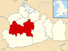
Fairlands is the largest settlement (neighbourhood) of Worplesdon, a village with a civil parish council in the Borough of Guildford, Surrey, England. The neighbourhood is centred 2.6 miles (4.2 km) north-west of Guildford, to which it is linked by a relatively straight road. The arbitrary centre of Worplesdon, a linear settlement, its church, is 1.2 miles (1.9 km) north-east.
| Fairlands | |
|---|---|
| Hamlet | |
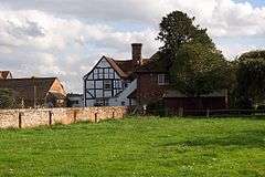 Fairlands Farm | |
 Fairlands Location within Surrey | |
| Population | 1,444 .[1] |
| OS grid reference | SU964525 |
| District | |
| Shire county | |
| Region | |
| Country | England |
| Sovereign state | United Kingdom |
| Post town | Guildford |
| Postcode district | GU3 |
| Dialling code | 01483 |
| Police | Surrey |
| Fire | Surrey |
| Ambulance | South East Coast |
| UK Parliament | |
Amenities
Fairlands has a parade of eight shops, a post office, a doctor's surgery, primary school, recreation ground and community centre. The latter is used for resident's association meetings, meetings of other groups of cross-sections of the community, and private hire events.
Directly north of Fairlands is the Equestrian Centre of Merrist Wood College, which specialises in horticulture, landscaping, garden design, animal care, countryside, golf, sports turf, floristry, arboriculture and equine studies - it encompasses 400 acres (160 ha) of land.
Residents Association
The Fairlands, Liddington Hall and Gravetts Lane Community Association (FLGCA) is formed of residents of Fairlands and the surrounding residential areas. The FLGCA administer the community centre, form an umbrella organisation for various groups specific to the neighbourhoods, and more generally act for the benefit of residents. A free monthly magazine is delivered to every house within its scope.
Youth outreach
The Normandy Youth Center serves the area by sponsoring community-based programs targeting youth in the area (especially marginal groups and minorities) for the purpose of increasing exposure to educational opportunities and building a stronger community.[2]
History
The small settlement developed in the 1930s from farms and heath/woodland on the inside bend of the Aldershot Road by developing a few roads of semi-detached houses and bungalows. Fairlands' main building period was around 1960 when many more roads were built. - its shops, community centre, doctor's surgery and school were built in the 1960s. The wholly green-buffered settlement is not bisected by any main roads and continues to reject street lighting, which adds strength to a suggestion the character of the settlement is semi-rural to rural.[3] Today 12 residential roads and closes form a clustered, garden-use dominated hamlet.[3]
Transport
Road
The Bagshot road from Guildford is a straighter regional route than the nearest route linked to it by two small cross-routes (1.3 km east of Fairlands), whereas the A323 Aldershot road from Guildford further from Guildford winds considerably, but adjoins Fairlands and provides an almost straight route from the community to Guildford, merging with the A322 shortly before the A3's Wooden Bridge interchange.
Rail
Worplesdon railway station is 2.5 miles (4.0 km) north-east.
Religion
Church of England
This 13th century ecclesiastical parish church (before the establishment of civil parishes providing a quasi-local government role with a vestry and poor relief for this neighbourhood), is an arbitrary centre of Worplesdon, a linear settlement around its central street and partially along intersecting routes, 1.2 miles (1.9 km) north-east.[4] Financially supporting the church as its patron is Eton College.
References
- Surrey County Council Census data Archived October 25, 2007, at the Wayback Machine
- Award for Mother Who Transformed Her Village Archived October 24, 2010, at the Wayback Machine; 18 October 2010 article; at (Surrey Herald etc titles via Get Surrey) News; retrieved 30 January 2013.
- Ordnance survey website
- Church of England - Diocese of St Mary the Virgin, Worplesdon
- RC Diocese of Arundel & Brighton - St Mary's Church Archived 2014-08-10 at the Wayback Machine
- Map of Alternative Churches of Guildford Deanery
External links
| Wikimedia Commons has media related to Fairlands. |
- www.fairlands.org.uk, the FLGCA website