Jacobs Well, Surrey
Jacobs Well or Jacobswell[n 1] is a small village in Surrey, England, of 20th century creation, with a population of 1,171. The village forms a northern outskirt of Guildford, in the civil parish of Worplesdon which can be considered the mother village of medieval date to the west. The Stoke Hill part of Stringers Common, Slyfield Industrial Estate and a Surrey County Council general waste transfer station to the south form the narrowest of its buffer zones to all sides, separating the Slyfield part of Guildford from the village.
| Jacobs Well | |
|---|---|
| Village | |
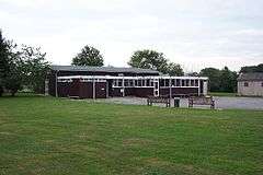 Village Hall on an edge of the network of residential roads | |
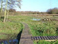 Boardwalk in Riverside Park in flood-meadows north of the settlement by the River Wey | |
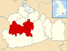
 Jacobs Well Location within Surrey | |
| Population | 1,171 [1] |
| OS grid reference | TQ0053 |
| District |
|
| Shire county | |
| Region | |
| Country | England |
| Sovereign state | United Kingdom |
| Post town | Guildford |
| Postcode district | GU4 |
| Dialling code | 01483 |
| Police | Surrey |
| Fire | Surrey |
| Ambulance | South East Coast |
| UK Parliament | |
Between Jacobs Well and Burpham to the south-east and east lie the River Wey, Burpham Court Farm Park[n 2], the River Wey Navigation, and the A3, in that order.
Other nearby settlements include Sutton Green (beyond which is Old Woking) to the NNE.
History
The manor of Burgham Court (now reflected in the farmhouse of Burpham Court) owned most of the land on the east side of the parish until the early 20th century. It was a major source of poor relief and public works under the local vestry. Outskirts of the land remain common land not owned by the lord of the manor. The manor was handed down via lines of the interconnected Wintershull/Wintershall, Bassett, Unwyn, Windsor, Wolley and Wroth families from Thurstan le Dispenser at the time of the Testa de Nevill. Ultimately purchased in 1720, becoming part of the major landholdings of the Earl of Onslow who held it until the early 20th century.[2]
Amenities
Aside from the green buffers to all sides, principally Whitmoor Common to the west, which is the largest, amenities include a scout hut and village hall.
A visitor attraction within these buffers is the gardens of the Tudor Sutton Place, in the borough of Woking to the north-east.[3]
Boats are available for hire at Guildford Boatyard, and elsewhere, for use on the River Wey Navigation, which forms the effective boundary of the village to the east. Bowers Lock is 0.6 miles (0.97 km) to the east, accessible from Clay Lane, the road to Burpham.
Religion
There is no church in the village, the nearest place of worship is St Peter's Church in Bellfields. The denomination is Anglican.[4]
Transport links
The village is on two significant through roads: the A320 from Guildford to Woking and the unclassified road, Clay Lane, that links Worplesdon to Burpham and the A3.
The railway between Woking and Guildford, the Portsmouth Direct Line, marks the practical boundary of the village to the west, however the nearest stations are Worplesdon and Guildford. The nearest of these, Worplesdon is 1.6 miles (2.6 km) away.[5]
Jacobs Well has roughly half-hourly bus services to and from Guildford and Woking.[6]
Notes and references
- Notes
- The Jacobswell alternative spelling is shown in a large minority of maps and signposts
- Its 'rare breeds' centre in the Metropolitan Green Belt is currently closed
- References
- Surrey County Council Census data Archived October 25, 2007, at the Wayback Machine
- H.E. Malden (editor) (1911). "Parishes: Worplesdon". A History of the County of Surrey: Volume 3. Institute of Historical Research. Retrieved 9 October 2013.CS1 maint: extra text: authors list (link)
- "Sutton Place, Woking". Parks and Gardens UK. Retrieved 13 August 2018.
- Stoke Hill St Peter's Church - Bellfields
- Grid Reference Finder distance tools
- Surrey County Council - Buses and Trains commitments
External links
| Wikimedia Commons has media related to Jacobs Well, Surrey. |
- Jacobs Well – how the name got its village at the Wayback Machine (archived 24 February 2012) – a comprehensive history of the village