Al Jawf Region
Al-Jawf Region (Arabic: منطقة الجوف Minṭaqah al-Jawf pronounced [alˈdʒoːf]), also spelled Al-Jouf, is one of the provinces of Saudi Arabia, located in the north of the country, containing its only international border with Jordan to the west. It is deemed one of the oldest habitation places in Arab Peninsula so that habitation places were found back to the Stone Age periods and Acheulean civilization. Habitation has continued there throughout the Copper Age and a kingdom has formed known as the kingdom of Qidar (the kingdom of Dumat al-Jandal and also the kingdom of Adumato) which was in rebellion and conflict with the Assyrian state for the independence, in this period which the name of the Arabs appeared in historical texts. Later a Christian kingdom arose under the rule of the Bani Kalb tribe and it has continued until the arrival of Islam and its annexation to Islamic lands. Then the Tayy tribe and its branches controlled the region and its surroundings. With the beginning of the modern era and the emergence of the third Saudi state, Al-Jouf was a site of conflict between the Al-Rashid family and the Al-Shaalan family, but the region was eventually subject to the rule of King Abdulaziz bin Abdul Rahman Al Saud as part of his plan to unify the regions.
Al-Jawf Region منطقة الجوف | |
|---|---|
| Al-Jouf | |
 | |
 Map of Saudi Arabia with Al-Jawf highlighted | |
| Capital | Sakakah |
| Manatiq (Districts) | 3 |
| Government | |
| • Governor | Prince Faisal Bin Nawaf Bin Abdul Aziz Al Saud |
| Area | |
| • Total | 100,212 km2 (38,692 sq mi) |
| Population (2017) | |
| • Total | 508,475 |
| • Density | 4.39/km2 (11.4/sq mi) |
| ISO 3166-2 | 12 |
The Al-Jouf region is considered one of the most fertile regions in the Kingdom of Saudi Arabia. As well as the Basitah Center – one of the Al-Jouf centers affiliated to Tabarjal town "the food basket of the Kingdom" due to the variety of its crops. Because of its geographical location in the region, its being a moderate climate in the summer, its soil fertility and abundant groundwater, that helped it to get this title. [4] The region is famous for cultivating olive trees [5], where actually Al-Jouf produces approximately 67% of the local olive oil production in the Kingdom. [6] Al-Jouf is also popular for planting palm trees, because it produces approximately 150,000 tons of dates every year [7], In addition to its production of fruits, vegetables, wheat and barley.
Etymology
The word "Al-Jawf " is from the land that has widened and fallen down and it became a cavity, which is broader than a channel in which the valleys flow in it. The word "Al-Jouf'' has been used to indicate more than one place in Arab Peninsula. One of them is the Yemeni governorate of Al-Jawf located between Ma'rib and Hadramawt Governorate in Yemen on one hand, and on the other, in Najran, in Saudi Arabia. Also, The word has been used to refer to the places in Yamamah and Diyar Saad. [10] Many regions bear the name of Al-Jawf, such as the Jawf of Muammar in the Asir region , [11] and Jawf Bani Hajir in the Eastern Province. [12]
Al-Jawf region was formerly known as Jawf al-Amr, and they are the clan of the Tayy tribe where they inhabited. It is also known as Jawf Al-Sirhan, a valley that extends from the northwestern tip of the Great Nafud desert until it reaches eastern Jordan. [13] The word al-Jouf is used locally to refer to the city of Dumat al-Jandal. [13]
History
Antiquity
Archaeological discoveries in the region evidenced that they were inhabited since ancient times, so that the Department of Antiquities and Museums discovered a site in 1977 near the center of Shuhitia (site 201-49), which dates back to the ancient Stone Age. In 1985, the archaeological team supervised Norman Whalen by studying the site, it turned out that there are16 sites near it, and that most of it dates back to the first Assyrian period. [14] In the year 1970, Frederick Winnett and William Reed published a book that included the results of their visit to the Archeology of the Rajajil columns in 1966. The site included many stone tools and pottery fractures that were used to determine the history of the site where it belongs to a civilization The Copper Age during the fourth millennium BC. Also, a group of burial cemeteries were found nearby the site. [15] Moreover, a group of stone circles and tools were also discovered at the site of Jabal Maqal, some dating back to the Copper Age. [16] Two ancient archeological villages were discovered having the first name "Site 201-54" and the other being named "Site 201-56". These two sites date back to the same period, which is the Copper Age. [17] It was recently found on many sites on the edge of the Nafud desert, the most important of which are: Site 201 – 60 and Site 201 – 61 which date back to the Middle Stone Age. [18]
Assyrian influence
The region has strategic importance for its control of the Incense Road, which passes from the south to the north and then to Mesopotamia, therefore it was coveted by the Assyrian state. The Assyrians considered its inhabitants who formed the kingdom of Qedar, a threat to them and their borders due to the permanent alliance of its leaders with their enemies and their attempt to rebel and support the rebels, where the first reference to the Arabs appeared during the reign of Shalmaneser III (858 BC ~ 824 BC) in a monument placed in the year 853 BC to indicate The Battle of Qarqar, in which King Jandibo and a 1000 of camels forces were defeated with the rest of the eleven kings who created an alliance against the Assyrian state. [1] Later during the reign of Tiglath-Pileser III (745 BC ~ 727 BC), Queen Zabibe, Queen of Arabia, was among the list of kings who had paid the royalty and named in the records [2] [3]. Later Queen Samsi has rebelled against Tiglath-Pileser III, betrayed the covenant between them and allied with the king of Damascus. [4 4] Therefore, Tiglath-Pileser III has declared a war on the queen, and he defeated her, killed 9,400 warriors, captured more than a thousand of her people and plundered 30 a thousand camels, 20 thousand sheep and five thousand bags of spices. He forced her to flee to the depths of the desert to survive her life. [5] Queen Samsi realized what happened to her and brought camels with her, she went to the king and declared obedience to him. Thereafter, Tiglath-Pileser III returned her to the rule and constituted an official to observe and monitor her with 10,000 soldiers. [6]
During the reign of Sennacherib (705 BC ~ 681 BC) Queen Yatie with Marduk-apla-iddina II's support defended Babylon from the army of the Assyrian state and sent her brother to take part in the battle in the city of Kish in the year 703 BC. [77] Later Sennacherib has prepared another campaign that eliminated the Queen Te'el-hunu, who succeeded Queen Yatie. In 688 B.C. He attacked her army, then he chased her after she escaped to Dumat al-Jandal. He captivated her with the Princess Tabua، plundered her servants and took them all to Nineveh. [19] Later during the reign of Esarhaddon (681 BC ~ 669 BC) the Assyrian texts referred that Hazael, who fled with Queen Te'el-hunu, became ruler of the Arabs, came to Nineveh with many gifts, kissed the king's feet and pleaded with him to return the gods of Dumat al-Jandal. The king Esarhaddon accepted that matter and appointed the Princess Tabua a queen with Hazael. [8] After the death of Hazael, his son Yatia became a king, but he faced a revolution that demanded independence from the Assyrian state, especially with the increase in imposed royalties, but the revolution was subsided by the Assyrian army. [ْ 9]
Subsequently, king Yatia rebelled against Esarhaddon during his preoccupation with trying to conquer Egypt and defeating the Pharaoh Taharqa. [20] Sennacherib's army defeated Yatia and took his gods again, but Yatia escaped. [20] Sennacherib died and Ashurbanipal took over after (668 BC ~ 627 BC). Yatia returned and pleaded with Ashurbanipal and swore loyalty to him. As soon as the gods returned to Yatia, he refused to pay royalties, gathered the Arabs to rebel against the Assyrian state again. Ashurbanipal has sent him an army that defeated him, his followers and forced Yatia to flee again. [20] After that, Attia, the wife of Yatia and the Queen of the Arabs has rebelled with Amoladi the new king, who attacked the Assyrian state, but was defeated, captured by the King Kamish Moab's king, taken to Nineveh with Queen Attia, who was defeated by Ashurbanipal and punished them. [20]
After Ashurbanipal defeated the Arabs, Ashurbanipal appointed Abb Yatia Bin Tari, as king, and imposed to him an annual royalty, but Abb Yatia joined the rebellion of Shamash-shum-ukin, the older brother of Ashurbanipal, and the king of Babylon. Abb Yatia has tried to enter into Babylon with his army, but the Ashurbanipal stationed forces defeated him, thus he had to flee. [21] He returned to Nineveh and asked for permission from the king, so then king again appointed him a king of the Arabs, but Abb Yatia rebelled again with the support of Yatia bin Hazael, the former king of Qedarite. This time, however, Ashurbanipal launched a major campaign against the kingdom of Qidar. He was able to capture most of the army, then chased the fugitives, so he prevented them from water, so some died of thirst, and others surrendered. [22]
Since the sixth century BC
With the fall of the Assyrian state and the emergence of the modern Babylonian Empire, it seemed that the relationship of the Arabs who inhabited the region with the new state was a peaceful relationship due to the absence of invasions and raids, even though Nebuchadnezzar II (605 BC ~ 562 BC) carried out several raids on Arab tribes in the sixth year of his rule. However, there is no evidence that these tribes inhabited this region. [23] Later, the policy of the Babylonian state has changed from peace to occupation, so that Nabonidus (556 BC ~ 539 BC) controlled lands that included Tayma, Lihyan, Khaybar, and Medina, located to the south of Dumat al-Jandal, the most important city of the former Qidar kingdom.. [23] Stephan G. Schmid and Michel Mouton stated that it is possible that the kingdom of Qidar cooperated with Nabonidus to eliminate the kingdom of Tayma in the south. [10] The Babylonian state did not last long after Nabonidus, it was captured by Cyrus the Great, king of the Achaemenids. (550 BC ~ 529 BC), however, the area was never subject to the authority of the Persians, according to Greek historian Herodotus. [23]
The kingdom of Qidar ruled a large area after the second half of the fifth century BC. These areas included southern Palestine until Tel Al-Douir, the Sinai Peninsula, the southern regions of eastern Jordan, and south to the Hijaz. [ْ 11] [ْ 12] Later, the Bible and Herodotus mentions that Geshem the Arabian was one of who feuded of the Prophet Nehemiah in rebuilding the walls of Jerusalem in the year 445 BC. [13] In the city of Pithom in West Sinai, silver vessels were discovered bearing the name of King Qinu ibn Geshem, the king of Qidar, who made a sacrifice to Lat, and it is believed to be the son of King Geshem whom mentioned in the Old Testament. [14] [15] After Alexander occupied the city of Gaza in 332 BC, the name of the Kingdom of Qidar started to disappear to emerge as the name of the Nabataean Kingdom instead. They have begun to take control of the Incense Road. [16] Later the Nabataeans lost control of maritime trade in the Red Sea and moved to expand their ownership in the southern lands, so Dumat al-Jandal came back to the fore because it linked the Jerwa, Petra, the capital, and the city of Bosra. [24] Archaeological inscriptions were in many sites dating back to the era of several kings, such as Aretas IV [25] and King Malichus II [26] and King Rabbel II. [27]
In the year 106 AD, the king Rabbel II died and the Emperor Trajan seized the land of the Nabataeans and annexed it under the name of the Arabian territory, [17] and the city of Dumat Al-Jandal is part of the Arabian Limes. Many authors considered that the annexation of the kingdom occurred peacefully, but numerous inscriptions later indicated that a Nabatean resistance had already taken place. [18] This resistance was manifested in the killing of King Malik III, who succeeded the Rabbel II. for three hundred Romanians. [19] Later it appears that these areas have been attacked during the crisis of the third century by the Kingdom of Palmyra, so that Zenobia (Al Zabaa) tried to take possession of the castle of Marid in Dumat al-Jandal, and she could not. Therefore, she said: Marid has rebelled, Al Ablaq has glorified. [23] Dumat al-Jandal later has continued as one of the Arab centers during the Byzantine era. the Dumat Al-Jandal market was one of the Arab markets in the pre-Islamic era. [23] Before the emergence of Islam in the area, Dumat al-Jandal was subordinated to the rule of the Kalb tribe, then to the king Akkidr ibn Abd al-Malik al-Nasrani, king of the Kingdom of Kindah, from the Sukoon tribe. [28]
Islamic history
The first mention of al-Jawf was in the month of Rabi` al-Awwal of the fifth year of Hijjrah when the Prophet Muhammadinvaded the city of Dumat al-Jandal to terrify Caesar because the city was close to the Levant, and people gathered in it to opprese by those who passed by them. They wanted to go to Medina. He left with a thousand Muslims until he reached it. He attacked the cattle of Bani Tamim, and the residents of Dumat al-Jandal dispersed. Then the Prophet stayed there for days, then returned to Medina. [29] In the following year, the Prophet sent a company led by Abd al-Rahman bin Auf to Dumat al-Jandal again، and it appears that its ruler at that time was al-Asbaj ibn Amr al-Kalbi. Abd al-Rahman bin Auf invited him to Islam, so they converted to Islam. Abd al-Rahman married from the Tamadhor (the king's daughter). [30] Later, Khalid bin Al-Walid has been sent by the Prophet to bring the Akkid during the Battle of Tabuk. Khalid ambushed him until he descended from the fort and brought him to the Prophet, so he saved his blood, reconciled him to tribute and released him. [31]
When Abu Bakr Al-Siddiq assumed the caliphate, he faced the wars of apostasy. The residents of Dumat al-Jandal and the nearby Arabs were of the apostates. In the 12th year of Hijrah, Khalid bin Al-Walid went to them after the Battle of Ayn al-Tamr. When his news reached Al Akkidar Bin Abdul Malik and Al Judi Bin Rabia, and they were leaders of the people, they differed. Al-Akkider saw the forces of the Muslim army, and he left Dumat al-Jandal, and Khalid bin Al-Walid sent to him who killed him. Muslims surrounded the city from two sides. The first was led by Khalid bin Al-Walid. The second was led by Ayadh bin Ghanem. The people of Dumat al-Jandal, were led by Al-Judi bin Rabia, and the Arabs were divided into two parts. Dumat al-Jandal and the Arabs army were defeated, the leaders were captivated, and the Arabs fleeded with the rest of the army to the fortress and closed it. Khalid bin Al-Walid remained in Dumat al-Jandaluntil he defeated its residents and uprooted the door of the fortress, then returned to Al-Hirah. [32] Later, the Jawf region was not mentioned except in brief references such as it that Imru Al Qais bin Al Asbagh Al Kalbi has been the ruler of the region during the era of Umar bin Al Khattab until the battle of Al Qadisiyah. Ayad bin Ghanem has succeeded him. During the era of Uthman bin Affan, Marwan bin Al Hakam has become a ruler over it before he became a writer in Medina, During the reign of Ali bin Abi Talib, arbitration took place between him and Muawiyah bin Abi Sufyan in Dumat al-Jandal, and then its mention was interrupted until the fourth century AH. [33]
In the fourth century AH, the thorn tribe of Tayy was strengthened in the region, the desert became known as the sand of Hathar (known as the Great Nafud Desert of our time), and the region became generally known as the Jawf al-Amr, and Bahtar and the Al-Amr are from the Tayy tribe. [34] After the seventh century AH, Al-Fadl family from the Tayy tribe took control of the region and strengthened their influence in it until the ninth century AH. [35] The influence of the Al-Fadl family decreased in the region, and a new alliance arose from the Tayy clans, the Alliance of Bani Lam and Bani Nabhan. This alliance began to attack the Al-Shami and the Egyptian Hajj route, and their attacks increased until their Sheikh forced the Ottoman Empire in the year 927 AH (1521 AD) to pay them Royalties. [36]
The invitation of Muhammad bin Abdul Wahhab and the influence of the first Saudi state reached Al-Jouf during the reign of Imam Abdul Aziz bin Muhammad bin Saud, specifically in the year 1208 AH (1793 AD). [37] As Ibn Bishr mentioned that Imam Abdul Aziz sent an army of the people of Al-Washem, Al-Qasim and Jabal Shammar, they took over three towns, killed many of the residents of Al-Jawf and besieged the rest until they pledged allegiance to the state. [38] During the reign of Imam Saud Al-Kabeer bin Abdul Aziz, the state remained in control of the region, which formed with Jabal Shammar a single emirate led by Muhammad bin Abdul Mohsen bin Fayez bin Ali. [39] In 1254 AH (1838 AD), the forces of Abdullah bin Ali al-Rashid were led by his brother Ubaid, attacked al-Jawf with a force of 3,000 men and forced the residents to pay zakat, but he did not leave a ruler or a representative there. [40] In the year 1269 AH (1853 A.D.), Talal bin Abdullah al-Rashid sent an army led by his uncle Ubaid and his brother Muteb, and within two years the area belonged to the Rashid family, which in turn was nominally affiliated to the second Saudi state. [41]
Modern history
Muhsin al-Shaalan, Al-Nouri's cousin, ceded the Qurayyat (Qurayyat al-Salt) region, which is the last remaining part of the al-Jawf region, and he ceded it in favor of the Saudi state. Ibn Battah was appointed a follower of Abdullah al-Tamimi, the emir of al-Jawf, [47] The Emirate of Transjordan, however, has rejected this. It saw that it was more deserving to rule the Qurayyat region, so it escalates with the Saudi state by demanding of establish a neutral zone between the two countries, the withdrawal of the Saudis from the Hijaz, and the return of the Al-Rashid family in Hail and the family of Al-Ayed in Asir to authority. This was rejected by Saudi state. As a reaction of that, Saudi forces crawled over the Jordanian villages until they reached Yadodah, a few miles away from the city of Amman, [48] At that time, Britain intervened by bombing the Saudi forces and forcing them to withdraw and return to the dialogue. Which was the case so the Saudi state agreed with Britain, which represents East Jordan, to give the Qurayyat region to Saudi Arabia and protect Saudi trade with Syria. That agreement was known as the Hada agreement. [49] After the annexation of the Hijaz, the Qurayyat region was known as the "Emirate of Qurayyat and the Northern Border Inspectorate." [50] At the end of the year 1349 AH (1931 A.D.), King Abdulaziz appointed for the second time Turki bin Ahmed Al-Sudairy a prince on Al-Jouf, and he moved the capital from Dumat al-Jandal to Sakaka. [51] One of the most important events that passed on Al-Jouf during this period is the protection of Sultan al-Atrash, the leader of the Great Syrian Revolution in Al-Jouf region from 1927 AD to 1932 AD. [52]
In the year 1358 AH, governmental departments in the Qurayyat region moved from the village of Kaf to the village of Nabak (which later became known as the City of Qurayyat). [53] In the year 1376 AH (1957 AD) Tabarjal was established after a part of the Shararat tribe settled in the region. [54] Kingdom of Saudi Arabia signed an agreement with the Kingdom of Jordan which was known as the Amman Agreement in 1965 to delineate the borders in the north of the Hijaz and confirm the previous agreement. [55] On 28 Shaaban 1412 AH (1991 AD), the zoning system was issued during the reign of King Fahd bin Abdulaziz Al Saud, and the Qurayyat region merged with the Jawf region and Tabuk region. [55] [56] The system also resulted in the formation of the District Council, which consists of 33 members, twenty of whom are residents of the region, and the rest are state employees. [57]
Population
Population growth in the Al-Jouf region is generally high, with a population of 520,737 people, according to the report of the General Authority for Statistics for the year (2018). [58] [59]
| year | Saudi Males | Saudi Females | Total Saudis | Non-Saudi Males | Non-Saudi Females | Total Non-Saudis | Total |
| 1992 | 112,403 | 111,003 | 223,406 | 33,699 | 11,123 | 44,822 | 268,228 |
| 2004 | 154,302 | 153,732 | 308,034 | 40,754 | 12,950 | 53,704 | 361,738 |
| 2010 | 177,379 | 171,733 | 349,112 | 71,231 | 19,666 | 90,897 | 440,009 |
| 2017 | 192,770 | 186,981 | 379,751 | 96,644 | 32,080 | 128,724 | 508,475 |
| 2018 | 196,228 | 190,435 | 386,663 | 100,760 | 33,314 | 134,074 | 520,737 |
Geography
Location
Al-Jouf region is located in the northwest of the Kingdom, and it is bordered by three Saudi administrative regions which are the Northern Border region to the north and east, the Hail region to the southeast, the Tabuk region to the southwest, and one country is the Hashemite Kingdom of Jordan to the north and northwest.
Geography of the region
Highs
There are many lava fields, hills and mountains in the region, such as:
- Harrat al-Harrat extends from Syria in the south through Jordan to Al-Jawf, and its area within the Kingdom's lands is approximately 15,200 km2, and it is located in the northeast of Al-Jawf region.
- Harra al-Rashrasheyah is located 16 km north of Qurayyat. [64]
- Harra al-Busaylah, is 17 km away from Kaf village. [64]
- The Hammad Plateau, a flat-level plateau is located to the north of Hurra al-Hurra, has many channels, and is approximately 800 to 850 meters high. [65]
- The Hajar Plateau is located to the east of the Hammad Plateau, and most of its lands are located in the northern border region. [66]
- Jabal Touqa (Touqa mountain) is located northwest of Sakaka Governorate, and is approximately 1039 meters high. [67]
- Jabal Naeej (Naeej mountain), is located northeast of Qurayyat, and it is approximately 1023 meters high. [67]
- Laila Mountain is located to the northeast of Tabarjal, and its height is approximately 897 meters. [67]
- Jabal Al-Hossan (Al-Hossan mountain), is located north of Qurayyat, is approximately 689 meters high. [67]
- Jabal Maqil (Maqil mountain), one kilometer away from the village of Kaf, where many tools from the Copper age and Stone Age were found. [68]
- Prince's Mountain, a two-peaks mountain in Sakaka, on the first summit is the Castle of Zaabal, and an ancient tomb is on the second summit. [69]
- Jabal Al-Saidi (Al-Saidi mountain) is located near the village of Kaf, and on the top, there is a fortress believed to belong to the Nabataean period of the area. [64]
- Qayyal Mountain, 12 km northeast of Sakaka, was found on the site of a Nabataean garrison. [70]
- Qarat al-Nisah, located 5 km west of Mossen, has found many inscriptions and foundations. [71]
- Qarat Al-Mazzad, is located 6 km north of the Alqait suburb, that is located northeast of Sakaka, and numerous inscriptions have been found there. [26]
Desert
The Great Nafud desert is located in the Al-Jouf region, which was previously known as Sand Alaj. It extends from Al-Jouf in its west to Hail in the east, and its area is approximately 64,630 km2.
Lows
There are many short and large valleys in the region, but the most famous one is the Sirhan Valley. It is the most important valley of Al-Jouf, its length is 180 km, and it has an importance in agriculture in the region. [73] There are several other important valleys such as Wadi Fajr and its length is 135 km. It flows into the Valley of Sirhan, [ Wadi Al-Ayli is the largest of Harra Al-Harra and one of Siran valleys. [73] [74] There are also other valleys, such as: Wadi Al-Shuhatiyah, Wadi Al-Merir, Wadi Hasida, Wadi Baar, Wadi Al-Safa, Wadi Hadraj, Wadi Al-Moi, and Wadi Al-Bayer. [75] [76]
Other than the valleys, there are Khabara (Swamps). The most famous one is Khabara Al-Amhas, which is a land where rainwater collects, some plants grow in, and is located in the desert of Hammad, [77],There also are many Sabkhas. The most popular is Sabkah Hadhodha, which is located near Al-Issawiya and covers an area of 540 km2, thus making it the largest Sabkhas of the kingdom's. [78]
Al-Jouf is also famous for Dumat al-Jandal Lake, and it is 585 meters above sea level, with an area of one million and one hundred thousand square meters. [79]
Climate
Al-Jawf region falls within the semi-tropical high pressure belt, which makes wind an influence in the region. In the winter, the arid northeast winds blow, making Al Jouf's weather stable and cool in this season. The astronomical location of the region may cause the development of air fronts as a result of the collision of the arid northeast winds with the humid southwest winds, causing Precipitation. [80] The maritime impact on the region is limited because the geographical location of the Jawf is far from the Red Sea, the Arabian Sea, the Arabian Gulf, and the winds through which it does not help in the rains. The Mediterranean is the sea that most affects the region. [80] The region is one of the coldest regions in Saudi Arabia during winter. Temperature reaches only 15 Celsius during the day in January, it drops to two degrees in the evening, and it may reach below zero. [81] In summer, temperatures reach 40 degrees Celsius in late July, and at night it drops to 19 degrees in the north of the region and 23 in the south. [81] High and low temperatures adversely affect the region in water loss, plant wilt or frost formation and damage to agricultural crops. [81]
Rain falls in the region mostly between October and May in the fall and winter seasons, and it decreases during the rest of the year. The average annual rainfall is about 80 mm. [82] The rains are fluctuating, falling one year significantly, but little in another year. [82] In general, however, when it is raining accompanied by the formation of hail, strong wind, thunderstorms, and torrential torrents. [82] This fluctuation and changing factors are detrimental to the region and its agricultural economy. [82]
| Climate Data of Al-Jouf | |||||||||||||
| Mounth | Jan | Feb | March | April | May | June | July | Aug | Sep | Oct | Nov | Dec | Annual average |
| Minimum Temperature
Fahrenheit (Celsius) |
86.5
(30.3) |
90.7
(32.6) |
97.9
(36.6) |
104.7
(40.4) |
108.7
(42.6) |
113.0
(45.0) |
116.6
(47.0) |
116.1
(46.7) |
113.4
(45.2) |
104.4
(40.2) |
104.7
(40.4) |
86.0
(30.0) |
116.6
(47.0) |
| Average of Maximum Temperature
Fahrenheit (Celsius) |
60.3
(15.7) |
65.1
(18.4) |
73.4
(23.0) |
84.4
(29.1) |
93.6
(34.2) |
100.9
(38.3) |
103.8
(39.9) |
105.3
(40.7) |
99.9
(37.7) |
89.2
(31.8) |
74.7
(23.7) |
63.7
(17.6) |
84.5
(29.2) |
| Daily Average
Fahrenheit (Celsius) |
49.5
(9.7) |
53.8
(12.1) |
61.5
(16.4) |
72.1
(22.3) |
81.3
(27.4) |
88.2
(31.2) |
91.0
(32.8) |
92.1
(33.4) |
86.5
(30.3) |
76.5
(24.7) |
63.0
(17.2) |
52.5
(11.4) |
72.3
(22.4) |
| Average of Minimum Temperature
Fahrenheit (Celsius) |
39.0
(3.9) |
42.3
(5.7) |
48.7
(9.3) |
58.3
(14.6) |
67.3
(19.6) |
72.9
(22.7) |
75.9
(24.4) |
76.8
(24.9) |
71.4
(21.9) |
63.3
(17.4) |
51.6
(10.9) |
42.1
(5.6) |
59.1
(15.1) |
| The lowest Temperature
Fahrenheit (Celsius) |
21.2
(−6.0) |
19.4
(−7.0) |
32.0
(0.0) |
33.8
(1.0) |
51.8
(11.0) |
59.0
(15.0) |
62.6
(17.0) |
65.8
(18.8) |
35.6
(2.0) |
48.2
(9.0) |
29.5
(−1.4) |
24.1
(−4.4) |
19.4
(−7.0) |
| Rainfall
inch (mm) |
0.52
(13.2) |
0.25
(6.4) |
0.23
(5.9) |
0.20
(5.0) |
0.07
(1.8) |
0.0
(0.0) |
0.0
(0.0) |
0.00
(0.1) |
0.02
(0.6) |
0.26
(6.5) |
0.28
(7.2) |
0.38
(9.6) |
2.21
(56.3) |
| Humidity (%) | 57 | 45 | 35 | 27 | 19 | 15 | 16 | 16 | 19 | 28 | 41 | 53 | 31 |
| The General Authority of Meteorology and Environmenal : 1985–2010 seasons | |||||||||||||
Administrative Divisions
The region is divided into the emirate's headquarters located in Sakaka Governorate, two (type A) governorates, the Qurayyat Governorate, and the Duma al-Jandal, and one (B) Governorate, Tabarjal. These governorates are divided into centers affiliated with them. The number of centers in the Al-Jouf region is 33 centers distributed among the four governorates. These centers are:
| Governorate | Centers | Total Population (2010) |
| Sakaka | Swayer | 176,266 people |
| KHowaa | ||
| Al-Fayyad | ||
| Athefa | ||
| Morair | ||
| Talaa Amar | ||
| Zalom | ||
| Um Athen | ||
| Al-showehatiah | ||
| Al-rafaeah | ||
| Hodab | ||
| Moq’era | ||
| Hurrah | ||
| Gader Al-khail | ||
| Qurayyat | Haditha port | 147,550 people |
| Al-essayuiah | ||
| Ein Al-Hawas | ||
| Al nasfaah | ||
| Al-hamad | ||
| Al-wadi | ||
| Qulib Khodoor | ||
| Radeefah Al-Jamajm | ||
| Duma al-Jandal | Abu-Ajram | 44,760 people |
| Al-Adhara | ||
| Asfan | ||
| Al-shagig | ||
| Al-radeefah | ||
| Tabarjal | Nabk Abu-qasir | 71,433 people |
List of governors
Since annexation of the region to rule the third Saudi state , 11 princes have ruled it, including Turki bin Ahmed Al-Sudairy, who has ruled for two different periods, and they are:
| Order | The name | Beginning of the period | End of period | Notes |
| 1 | Assaf Al-Hussein | 1341 | 1343 | - |
| 2 | Abdullah bin Mohammed bin Aqeel Al-Tamimi | 1343 | 1345 | - |
| 3 | Turki bin Ahmed Al-Sudairy | 1345 | 1346 | The first period |
| 4 | Abdul Rahman bin Saeed | 1346 | 1348 | - |
| 5 | Ibrahim bin Abdul Rahman Al-Nashmi | 1348 | 1349 | Acting prince |
| 6 | Turki bin Ahmed Al-Sudairy | 1349 | 1351 | The second period |
| 7 | Abdulaziz bin Ahmed Al-Sudairy | 1352 | 1357 | - |
| 8 | Mohammed bin Ahmed Al-Sudairy | 1357 | 1362 | - |
| 9 | Abdul Rahman bin Ahmed Al-Sudairy | 1362 | 1410 | - |
| 10 | Sultan bin Abdul Rahman Al-Sudairy | 1410 | 1419 | - |
| 11 | Abdul Ilah bin Abdul Aziz Al Saud | 1419 | 1423 | - |
| 12 | Fahd bin Badr bin Abdulaziz Al Saud | 1423 | 1439 | - |
| 13 | Badr bin Sultan bin Abdulaziz Al Saud | 1439 | 1440 | - |
| 14 | Faisal bin Nawwaf bin Abdul Aziz Al Saud | 1440 | The current prince |
The princes of the Qurayyat region
Nine princes have followed over the Qurayyat region from the time Muhsin al-Sha’lan abdicated it until her annexation to the Al-Jawf region, and they are: [47] [89]
| Arrangement | The name | Beginning of the period
Islamic History |
End of period
Islamic History |
Notes |
| 1 | Ali bin Battah | 1344 | 1348 | - |
| 2 | Abdullah bin Hamdan | 1348 | 1349 | eight months |
| 3 | Abdullah Al-Hawasi | 1349 | 1353 | - |
| 4 | Saleh bin Abdul Wahid | 1353 | 1354 | - |
| 5 | Abdul Aziz bin Zaid | 1354 | 1357 | - |
| 6 | Abdulaziz bin Ahmed Al-Sudairy | 1357 | 1375 | - |
| 7 | Abdullah bin Abdulaziz Al-Sudairy | 1375 | 1385 | - |
| 8 | Sultan bin Abdulaziz Al-Sudairy | 1385 | 1405 | - |
| 9 | Sultan bin Abdullah Al-Sudairy | 1405 | 1414 | Qurayyat was attached to Al-Jouf region |
Public services
Transportation
The region is connected with the capital Riyadh by a 1309 km long road that passes from the city of Sakaka and reaches the city of Arar. It is also linked to the city of Jeddah (on the Red Sea coast) through the city of Dumat al-Jandal and the city of Madinah by a road with a length of 1258 km. Furthermore, the provincial centers in the region are connected to each other. [90] There are two airports in the region: The first is in the city of Sakaka is known as the Al-Jouf Domestic Airport(AJF / OESK), and the other airport is in Qurayyat and is known as the Gurayat Domestic Airport (URY / OEGT). It is planned that the region will also be linked with the rest of the Kingdom by a network of railways within the North-South Train (SAR), which links the capital Riyadh with the cities of Sakakah, Qurayyat, Haditha and the Basita farms.
The distance between the emirate's headquarters in Sakaka city and the different cities of the Kingdom in kilometers (km):
| City | Riyadh | Jeddah | Dammam | Mecca | Medinah | Abha | Tabuk | Taif | Hail | Jazan | Najran | Toriaf | Albaha | Yanbu | Juail | As Sulayyil |
| Sakaka | 1309 | 1258 | 1225 | 1271 | 913 | 1999 | 504 | 1359 | 380 | 1956 | 2163 | 204 | 1575 | 1150 | 1136 | 1870 |
Education
Like other regions of the Kingdom, education was limited at the beginning to the Kuttab in mosques where the Qur'an and the Arabic language are taught, and wood planks and tamarix sticks are used for writing. In the year 1362 AH, the first regular school in the area, the Emiri School in Sakaka, was opened, and it includes one class and one teacher. In 1364 AH, the Omar bin al-Khattab School was opened in the city of Dumat al-Jandal, and then opening formal schools has continued. [92]
In the year 1369 AH, the Al-Jouf region with the Qurayyat and Tabuk regions submitted a request to King Abdulaziz to grant a financial reward to each student, and the king agreed. [93] Later, with the increase in the number of schools, the task of supervising them was assigned to the education of the Madinah region, then to the education of Dammam. In the year 1377 AH, the Central Inspection Office was established to link between Al-Jouf and Dammam. In the year 1388 AH, the Central Inspection Office turned into a special "education office" in the region, then to an "Educational Supervision Bureau" and finally in the year 1398 AH to an "Education Administration." [93]
The first school for girls was opened in the region in the year 1382 AH. and in the year 1401AH, the College of Education for Girls arose. In the next year, the Health Institute for Nursing was established, and the "Girls 'Education Commission" became an independent department in the name of "the Department of Girls' Education in Al-Jouf". [93] The following year the Boys' Health Institute was established, and in 1423 AH, the College of Science for Boys was established. [93] In the year 1426 AH, Al-Jouf University was opened. [94]
Healthcare
The central hospital in Sakaka (Abdel Rahman Al-Sudairy Hospital) was built in the year 1385 AH (1965 AD) to be the first hospital in the region, and this hospital was specialized in chest diseases due to the spread of tuberculosis in the region. With the increasing population need for hospitals, King Faisal Hospital in Qurayyat, the Diagnostic and Obstetric Center in Dumat al-Jandal, and the Ambulance and Obstetrics Center in Tabarja were established in the year 1395 AH. [95] In 1404 AH, the Mental Health Hospital was established, The General Hospital was opened in Qurayyat in 1405 AH. On the first of Rajab 1406 AH, the Health Affairs Department was established Al-Jouf after it was affiliated with the Health Affairs Directorate of the Northern Health in the city of Arar, [95] In 1425 AH Seven hospitals and 29 health centers were affiliated with the Health Affairs Department. [96] In the following year, the Sawyer General Hospital was established, and in 1433 AH, the Abu Ajram General Hospital was established. [95]
Economy and natural resources
Agriculture
Formerly, agriculture is considered the basic profession of the region's residents. Backpackers have described agricultural crops in Al-Jouf as they pass through it. Among the them who referred to the agricultural crops is the Finnish backpacker George August Wallin (Yrjö Aukusti Wallin) who mentioned that palm trees, figs, apricots, oranges and grapes are planted in the region, [97] This is what also was indicated by the William Palgrave adding that dates are the only crop that It is sold outside the region. [98] In the modern era, Abdul Rahman bin Ahmed Al-Sudairy, the governor of Al-Jawf region, mentioned that olives, apples, pears, pomegranates, wheat and barley are grown in the region. [8] The Guinness Book records that the largest modern olive farm in the world is also found in Al-Jouf. [99]
Agricultural machines were brought to the region in the year 1368 AH. [100] Branch of the Ministry of Agriculture was established in the year 1379 AH [100]. Then the emirate distributed agricultural lands to citizens [100]. The number of distributed farms reaching 7,500. [101] The region is now famous for cultivating an olive tree, and it produces 67% of olive oil in the Kingdom of Saudi Arabia. [6] Olive trees began to be planted in 1392 AH. [6] In 1437 AH (2016 AD), the number of olive trees reached 18 million trees producing between 30 and 40 thousand tons of olives and 10 thousand tons of olive oil. [102] The number of olive presses reached 23 presses. [6]
In addition to olives, there are 10 million fruit trees in Al-Jouf annually producing 170 thousand tons. Also, there are 1.2 million palm trees annually producing 40 thousand tons of dates, the most famous of which is Hilwah Al-Jouf. The number of Al-Jouf farms is 12 thousand farms and 3 thousand agricultural projects that contain 30 million trees that produces olives, palms, fruits, vegetables, and fodder. [102]
Among the most important problems facing agriculture is the problem of depleting groundwater with the increasing number of agricultural projects, especially in the Basita Farms Project and the cultivated areas, where the cultivated area reached 428 thousand hectares. [103]
Livestock
In 1402 AH, corresponding to 1982 AD (the former name of the ministry at the time), the Ministry of Agriculture and Water started the project of the rangeland development center and improved it to preserve livestock in the Al-Jawf region in cooperation with FAO. The center included several departments working on rangeland management, soil conservation, production management and animal health . [104] The National Wildlife Protection and Development Authority has established several reserves to protect the region's animals and planets. [104]
According to the statistics of 1426 AH corresponding to 2005 AD, Al-Jouf Region included 1,569,733 heads of sheep, 1,740 heads of cows, 7,398 heads of camels, 88,845 heads of goats, and 2,791,227 poultry. The region included 6 projects for raising chickens , 4 projects to produce eggs, and 3 projects specialized in breeding and fattening lamb. [104]
Industry
Before the establishment of the Saudi state, the industry in the region was handcrafted products, such as: leather industry, such as horse belts, arms sheaths and water closures, weaving industries such as cages, utensils, baskets and fans, wooden industries such as doors and some agricultural tools, stone industries such as the millstone, the grind and the mortar, and woolen industries such as sleeping mats, carpets and the abaya. [105] The industry before the year 1390 AH (1970 AD) was very limited, but it was increasing. Several industrial workshops were opened which numbered in the year 1418 AH nearly 200 workshops, and the number of factories reached 20 factories in the year that followed and their investments amounted to 112 million riyals at the time. Investment rose up to 220 million riyals in the year 1425 AH (2004 AD). [106] 12 factories specialized in the food and beverage industry, then 4 factories for the chemical and plastic industries, and 4 factories for the building materials, ceramics and glass industries. [107]
The industrial contribution in the region is limited, so that the number of factories in the region represents only 0.53% of the factories in the Kingdom of Saudi Arabia. The number of their workers represents only 0.23% of the number of workers in other factories, and the invested capital represents only 0.08% of the invested capital in the rest of the factories. [108] Industrial projects in the region are mostly individual projects with limited funding. all of them are national in the absence of foreign investment. Most industrial activity is limited to the food and beverage industry, depending on wealth and potential in the region. [108]
Minerals
The Ministry of Petroleum and Mineral Resources (now called the Ministry of Energy, Industry and Mineral Resources) has conducted exploratory and prospecting studies for the region. Consequently, the presence of many raw materials was determined, such as: clay in the areas of Jal Ajrabeh and Al Dhailiya, which is used in the manufacture of building materials. Silica sand is found in the areas of Al-Malih and Al-Luja and on the extension of the Tabuk road, southeast Sakaka. Silica is used in the manufacture of glass, and it exists in its forms of quartz, opal, and chalcedony. [109] In the region, there are also basalt rocks found in Hurra Al Hurra, and enter in the manufacture of Pozzolan cement. The region also contains limestone rocks found in Wadi Al Hablah and western Jabal Al Abd, dolomite rocks along the Sakaka Arar road, the mineral phosphate found in Hurra Al Hurra, and salt found in Wadi Al-Sarhan, Hadhodhaa, Kaf, and Etherh. [109]
Trade
In the past, trade in the region depended on the system of bartering and the exchange of goods according to the needs of the individual. The region suffered in the year 1356 AH (1937 AD) and until the year 1365 AH (1945 AD) for two reasons, namely the lack of imports due to the weak financial resources of the population, and the Second World Warthat caused an economic crisis to a number of countries in the world. [110]
With the development of the state and the emergence of chambers of commerce, increasing records and licenses, securing basic life necessities and developing income sources among the population as a result of development, the number of markets, commercial complexes, individual institutions and companies has increased, which numbered 6191 institutions and companies in the Al-Jouf region. Among the most important commercial activities in the region in the commercial sector are wholesale and retail trade in foodstuffs, electrical and sanitary ware, fabrics and clothing. [111]
Because of its geographical location in the northwest of the Kingdom of Saudi Arabia, A large portion of land trade passes through a Al-Hadithah port, one of the most important commercial outlets for the Kingdom, and it is one of the largest and most important outlets in the Middle East region linking the Gulf Cooperation Council states with Jordan, the countries of the Levant, Egypt and Turkey, the destination to the countries European. [112] The region has a branch of the Ministry of Trade and Investment that issues licenses to companies and institutions, combats commercial fraud, conforms to specifications, and monitors markets to protect consumers. [112]
Wildlife
Vegetable cover
The vegetation is weak in many locations. The most important plants that form the cover are: Lavender, Ziziphus, Opophytum, Truffles, Malva, Plantago ovata, Maha, Erodium, Artemisia, Achillea, Pulicaria, Asafoetida, chrysanthemum, Haloxylon, Haloxylon persicum, Calligonum, Tamarix, Rhanterium epapposum, Neurada procumbens, Atriplex, Salsola, Anisosciadium, Lepidium, Diplotaxis, Papaver dubium, Erucaria, Hippocrepis unisiliquosa, Sonchus, Anchusa, Tragopogon, Scorzonera, Allium sindjarense, Leek, Chamomile, Clover, Thyme, Anemone, Stipagrostis, Retama, Lycium shawii and Aloysia. [104]
Animal life
Mammals
Desert and mountain environment in Al – Jouf contributed to the existence of many mammals. In the region, there are five species of the order of even – numbered Hoof namely the Arabian oryx , and Goitered gazelle, Ghazal junction , Dorcas gazelle , and Nubian ibex. These species are deemed one of the rarest species in the region due to overfishing that they were exposed to in the twentieth century which led to their disappearance from all or most of their natural habitats. There are also seven species of the order of Carnivores, Arabian wolf , Rüppell's fox , Red fox, Honey badger , planned hyena , Sand cat, and a wild cat. Numbers of these species are constantly decreasing because they are considered a threat to livestock and Badia residents. Finally, in the area, there are ten species belonging to four order of insectivora, desert hedgehog from erinaceidae order, Cape hare from lagomorpha order, Rock hyrax from Aleupreat order, and finally Rodents order, which 7 types belong to it, they are Cheesman's gerbil, Wagner's gerbil, Libyan rat, Sundoval rat, Lesser Egyptian jerboa, Euphrates jerboa, and Porcupine.
Birds
The first person who wrote about the birds of the region was John Philby in the year 1923. The most important thing, he mentioned was that the Arabian ostrich, which was raised in Dumat al-Jandal and was found naturally in Wadi Al-Sarhan. [114] Studies in the area have continued to register birds, there was Richard Minershagen's study in 1954, Arthur Green's study in 1983, a study by the National Wildlife Service, then a study by British bird scientist Michael Jennings in 1995. [114] The Harra Al Hurra and Dumat Al Jandal Lake are the two most important regions in Al Jawf for birds; first provides protection for birds due to the difficulty in accessing and hunting people, and the second is a wet area where birds visit. During the surveys in the nineties of the twentieth century, more than 10 thousand birds were registered in Winter. [114] Birds in Al-Jouf suffer from overfishing, the disappearance of natural areas, and their vulnerability to unregulated human consumption of groundwater. [114] Although many birds live in the region, and it is considered a transit area for birds in their migration, yet only 170 migratory species have been registered there. [114]
Reptiles
In Al-Jawf region, there is one of the four orders of reptiles, which is the order of the Squamata. There specifically is the existence of Twenty-two species of Lizards, and nine types of Snakes. [115] Most of these species are found in good numbers in their natural habitats, but the Uromastyx aegyptia may face the risk of extinction due to the overfishing that it is exposed to. In addition to that, Elegant racer, Egyptian catsnake, and Desert black snakes are found in small numbers in their original habitat. For Jan's Cliff Racer, its numbers are medium in its places of spread. [115].
Arthropods
The Kingdom’s environment is rich in many types of Arthropods, and many of them live in the Al-Jawf region. These types are classified in several classes such as arachnid and have several s such as Spiders, Solifugaes, Scorpions, and Acari. [116] There are also other classes such as Centipede. There is in Al-Jouf only one type is Scolopendra (known locally as the mother of the forty-four). Also, there is insects class, and many belong t o it such as cockroaches, Orthoptera, Homoptera, Hemiptera, Beetles, Lepidoptera, Hymenoptera, and Diptera order. [116] These insects may be harmful to agricultural crops, disturbing people and most likely being gotten rid of. [116]
Culture and tourism
Archaeologies
The region has many archaeological sites that date back to the stone and copper ages, and extend through the era of Qedar, the Nabataeans and Roman influence, to reach the first era Islam. Then, it is followed by the ages of the Umayyad and Abbasid states, the Ottoman era and the rule of the Shaalan family, then the Saudi state. In these sites, there were discovered settlements, tombs, pottery, Thamudic, Nabatean, and Roman inscriptions, as well as Arabic inscriptions from various Islamic periods.
| The name | the description | Source |
| Qarat Al-Mazad Inscriptions | They are a group of inscriptions on the eastern side of the mountain bearing military titles, and it is believed that they are related to the Nabataean garrison that was camped near the mountain. These inscriptions belong to the first and second centuries AD. | |
| Columns of Rajajil | It is a site with an area of three square kilometers. It was used as burial sand established about 4500 BC. There are four stone columns at each burial, with a circular stone next to it and a room for performing the rituals. Also found on the site many tools such as scrapers, plates, cups, decorations, and also found several rocky drawings. | |
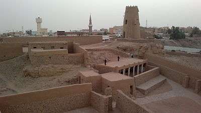
| Zabal Caslte | It is an ancient castle built 300 years ago on the ruins of a Nabatean castle that dates back to the presence of the Nabataeans in the region. The castle has only one entrance and four towers used for observation and wars. The castle is approximately fifty meters above the city level, and it is a popular destination for tourists visiting the region. | |
| Sisira Well | It is a carved well with a stone named after Sisra Al- Canaani, commander of the Yabin army, King of Tel Hazor who fought the Jews. There is a stair allowing to go down. There is a carved canal that transports water to the rest of the city, and it is connected to Lagait suburbs in the east of the city with a tunnel of three kilometers long. | |
| The inscriptions and tomb of Ghar Hazrat | It is a sculpted grotto that does not know the date of its sculpture, and the reason for calling it by this name, but the name is attributed to a man called Hazrat. He was the first companion that came to the city, but Hamad Al-Jasser questioned and said that "this man may be older than you think.". The method of carving is the same as that of Madaen Saleh . | |
| Moosen Castle | The construction of the castle dates back to the period between the third and sixth centuries AD. Many rock inscriptions of the first and second centuries AH were found on the crossing of pilgrims to Mecca . Irrigation channels, ancient wells and evidence of cultivation were found around the palace. | |
| Aishan Palace | It is a palace built in the thirteenth century AH of clay and stones in an oasis area that includes palm trees and taramix. The palace has two entrances, wells and towers in the southeastern corner and in the northwestern corner. Next to it, there is a mosque built of stone and covered with palm fronds, which is in good condition. | |
| Al-Shuwaytiah Settlements | They are a group of settlement sites and raw materials located in Al-Shuhaitia Center, bearing the number 49/191, and they reached more than 16 sites. These sites, according to the studies conducted, are suitable for the residence of the ancient person due to the presence of water from Wadi Al-Sarhan and the presence of caves that protect people in times of disasters. | |
| Qayal | It is a Nabataean site where a garrison was stationed at Jabal Qayal to protect the trade route heading from Dumat al-Jandal to the south of the Mesopotamia valley and east of the Arabian Peninsula. A residential village, two different buildings, numerous Nabataean inscriptions and the pottery fragmentation known as "the Nabataean eggshell pottery" were found on the site. | |
| The manufacturing zones in Sakaka trough | It is an area where many stone tools were found that were used in Stone Age. There was no human stability in the area, but it was a mining area so that Flint stones, that spears in the site, were used to make incomplete tools. | |
| Laqtah Pottery | It is an archaeological site on the northern edge of the Nafud desert, and this caused a large part of the archaeological site to be buried under the sand. On the site, archeological hills, traces of mud foundations, masonry units, earthenware fractures, and walls surrounding the site were found. The place dates back to between the second century BC and the first century AD. The pottery that was found confirms the site's connection to other places in the Arabian Peninsulaand that the site was far from Hellenistic influence on the place and that it belongs to an Arab civilization. | |
| Al Qadeer Building and Inscriptions | The site includes a small stone building known as Qasr al-Qadeer (Al-Qadeer Palance), a well located to the north of it, and the remains of destroyed stone foundations. Many stone drawings, Thamudic inscriptions and Islamic writings from the period between the sixth and eighth centuries AH were found at the site, and it is believed that it was located on one of the ancient paths of Hajj. | |
| Qarat Al-Nissah inscriptions | The site includes a large collection of stone drawings, Thamodic inscriptions and early Islamic inscriptions. It is believed that the site was a station for the rest of the pilgrims, so that more than 100 Islamic inscriptions belonging to the Abbasid era were found, except for one that belongs to the era of the Umayyad Caliph Hisham bin Abdul Malik. | |
| Al-Dar'a neighborhood | Al-Dar'a neighborhood is the old town in Dumat al-Jandal and dates back to the Islamic period. Building areas and layouts vary, but there is one or two courtyards that include seating-rooms and bedrooms. The houses surround a large square that spans four streets. | |
| Marid Castle | It is an ancient castle that dates back to the Nabataean era, and it was the Headquarters of rule in Dumat al-Jandal. The castle is surrounded by four towers, three of them are connected to each other, which greatly facilitates movement. The castle is surrounded by a wall, another wall has been added to it in the southern, eastern and northern side because it represents a weak point of the castle. The height of the second wall is approximately eight meters. The castle has one entrance to the south. | |
| Omar ibn Alkhattab mosque | It is a mosque attributed to the second caliph Al-Rashid II Umar ibn Al-Khattab and its importance lies in the fact that it represents the ancient architecture model at the beginning of Islam. The minaret is unique in the style of minarets in the Arabian Peninsula, but it was influenced by the urban style of the Umayyad period. | |
| The wall of Dumat Al-Jandal | It is the wall that surrounds Dumat al-Jandal. The remaining length of it is approximately one thousand meters, where part of the wall was destroyed and another part was buried under the sand. The construction of the fence dates back to the first century AD. | |
| Dumat al-Jandal Market | It is the center of Dumat al-Jandal, formerly one of the Arab markets in pre-islam. The shops were built of stone, but now they have been destroyed. | |
| Burial and inscriptions of al-Sanimiyyat | They are Nabatean burials built of stones in which stone vessels, ornaments and coins were found from the time of the Aretas IV Philopatris, king of the Nabataeans and Roman coins dating back to the year 118 AD. | |
| Stone circles in the Sirhan Valley | It is a group of stone circles in two different locations in the valley. The first site contains about fifty stone circles, and the second has about a hundred stone circles. Many stone tools have been found in the vicinity of these circles. It is believed to date back to the fourth millenniumBC. | |
| Al-Saeedi Castle | It is an ancient castle dating back to its use according to archaeological evidence, to the middle of the first millennium BC, where many pottery pieces dating back to the Median period were found. The castle has a wall that surrounds the entire flat surface of the mountain and rises approximately four meters. The castle is surrounded by a large number of square towers, especially in the eastern façade, which contains the entrance to the castle, which leads to the square where the rooms, the well and the water tank are located. | |
| Aqila Al-Mashaan Palace | It is a huge building, it was built of basalt stone, and it has been exposed to modern cliff works. The walls of the building rise about one and a half meters and it represents a presence of an old town. Pottery fragments dating back to the first millennium BC have been found on the site and they have continued to be used in the Nabataean and Byzantine period. | |
| Al-math'han Palace | It is a building built with basaltic stones, and it is believed that it has been built during the Nabatean era due to the similar style of construction to the Nabataean structures and the presence of the Nabati pottery fracture at the site. A wall of basalt stones surrounds the building, and it has two entrances in the north and southeast, which lead to rooms inside the building. An Arabic inscription in Kufic font was found in the palace believed to date back to the Umayyad period. | |
| Al-Kharab Palance | It is a building constructed from basalt stones and its rooms were destroyed. It was mentioned by Backpacker, Winette , it is a rectangle building with wall, and possibly it is a religious temple. It was dated to the Nabataean period due to the pottery in it. | |
| Al-wasyah
Palace |
It is a two-room building built from black basalt stones. It has been buried and a two-storey mud house built above it. The palace has water channels and a well around it. | |
| Al-Raslaniyah Palace | It is a multi-room building, and only its foundations were left. Mud rooms were built upon, roofed with tamarix and Palm leaves. | |
| Cemetery and tombs of Naij | They are houses and burial sites, only some foundations and walls remain of them. Many inscriptions and rock drawings of the animals of the region were found, and they were drawn on basaltic stones. | |
| Hurrah Basseliah Stone Houses | They are a group of stone houses in the bottom of Al-Harrah، and around the site, there are many stone pieces. | |
| Burials and inscription of Hurrah Alrashrash | They are the foundations of houses, cemeteries, and a rock area with many inscriptions and writing. | |
| Stone circles in Maqal Mountian | They are a group of randomly designed stone circles that were found in the Meshar Valley at the foot of Maqal Mountian. On the site, many tools such as sharpeners, sharpening tools, planers, and brass stone ages tools were found. The history of the stone circles is different and does not date to the same period. |
museums
Al-Jouf region contains one general museum, Al-Jouf Museum, located in Dumat al-Jandal Governorate near the archaeological area and its current area is 3600 m 2. [143] The governorate also includes many private museums such as Al-Nuwaiser Heritage Museum, which consists of two halls and many rooms that include a popular market having numerous ancient coins, local industries, and farming tools. [143] Furthermore, Wethiman Museum, which displays local industries, war tools, and wool products. [143] In other cities, there are museums such as the Tree Museum for Heritage located in Qurayyat. A large tree mediates it, and a heritage tent and a building divided into three parts surround the tree and display old publications, mummies and local artifacts. [143] In Sakaka, on the other hand there is the Nasser Qadir Al Arouj Heritage Museum, which displays many artifacts, coffee and hospitality tools, a range of war tools and weapons, some leather goods, and farming and house tools. [143]
Festivals
Al-Jawf has many festivals that most of them are related to the region's special crops. Among the most famous festivals held in Al-Jouf are the Olive Festival, which number of visitors reached to about 95 thousand, [144] Also, Al-Jouf Dates Festival includes 85 exhibition of dates in the region, and it contains 90 luxurious varieties of dates [145] [146] [147] In addition to the fruit festival, there are traditional festivals that are held in the region such as Al Sadu Festival that contributes to maintaining and spreading the craft of Al Sadu industry in the region and supporting productive families, [148] Moreover, Mogidh Tabarajal Festival for Camels supports camel racing sport. [149] Finally, Tabarjal's Festival for the Revival of Heritage has nearly 20,000 visitors annually. [150] Many summer festivals are held in Al-Jouf, just like other regions in Saudi Arabia
Traditional Cuisine
The region abounds with many special foods. Because of its proximity to Hail, they shares many foods. One of the region's special foods is the "bakkila",and it is made by mixing the dates of Al-Jawf, known as Al-Helwa, with the al-Samh plant after roasting its grains, known as al-Sabeeb, with natural ghee. In addition to many other regular saudi food such as Kabsah . [155]
Sport Clubs
Six Soccer Clubs was established in Al-Jouf, they are:
| Order | Club | League | Establishing Date | Reference |
| 1 | Al-Orobah FC | First Division | 1975 | |
| 2 | Al-Qala'ah | Third Division | 1974 | |
| 3 | Al-Entilaq | Third Division | 1983 | - |
| 4 | Al-Jandal | Third Division | 1976 | |
| 5 | Al-Qurrayat | Third Division | 1975 | - |
- Winston's Hiccup
References
- Israel Ephʻal. Page 21.
- ^ Hayim Tadmor. Page 87.
- ^ Israel Ephʻal. Page 82.
- ^ Israel Ephʻal. Page 84.
- ^ Israel Ephʻal. Page 85.
- ^ Jan Retso. Page 133.
- ^ Hans Wildberger. Page 332.
- ^ Daniel David Luckenbill. Page 207-208.
- ^ Daniel David Luckenbill. Page 208.
- ^ Michel Mouton, Stephan G. Schmid. Page 9.
- Margreet L. Steiner, Ann E. Killebrew. Page 118.
- ^ Michel Mouton, Stephan G. Schmid. Page 10.
- ^ Michel Mouton, Stephan G. Schmid. Page 10.
- ^ Michel Mouton, Stephan G. Schmid. Page 10.
- ^ Dumbrell, Stephan G. Schmid. Page 36-37.
- ^ Michel Mouton, Stephan G. Schmid. Page 12.
- ^ Al-Otaibi, Fahad. Page 152.
- ^ Al-Otaibi, Fahad. Page 152.
- ^ Al-Otaibi, Fahad. Page 153.
- The Ancient Arabs: Nomads on the Borders of the Fertile Crescent, 9Th-5Th Centuries B.C. Israel Ephʻal. BRILL, 1982. ISBN 9652234001.
- The inscriptions of Tiglath-pileser III, King of Assyria. Critical edition, with introductions, translations and commentary. Hayim Tadmor. The Israel Academy of Sciences and Humanities, 1994. ISBN 9652081116.
- The Arabs in Antiquity: Their History from the Assyrians to the Umayyads. Jan Retso. Routledge, 2013. ISBN 1136872825.
- Continental Commentary Series. Second volume (13–27). Hans Wildberger. Fortress Press, 1997. ISBN 0800695097.
- Ancient Records of Assyria and Babylonia. Second volume. Daniel David Luckenbill. University of Chicago Press, 1927.
- The Oxford Handbook of the Archaeology of the Levant: c. 8000–332 BCE. Margreet L. Steiner, Ann E. Killebrew. OUP Oxford, 2014. ISBN 0191662550.
- Men on the Rocks: The Formation of Nabataean Petra. Michel Mouton, Stephan G. Schmid. Logos Verlag Berlin GmbH, 2013. ISBN 3832533133.
- Dumbrell, William J.. 1971. "The Tell El-maskhuta Bowls and the 'kingdom' of Qedar in the Persian Period". Bulletin of the American Schools of Oriental Research, no. 203. American Schools of Oriental Research: 33–44. DOI:10.2307/1356289.
- Al-Otaibi, Fahad Mutlaq . (2015). The Annexation of the Nabataean Kingdom in 106 A.D: New Epigraphic and Archaeological Consideration. Mediterranean Archaeology and Archaeometry, Vol. 16, No 1,(2016),pp. 151–156. DOI:10.5281/zenodo.27743
External links
- A travel through the province of Al Jouf, Splendid Arabia: A travel site with photos and routes
Places adjacent to Al Jawf Region | ||||||||||
|---|---|---|---|---|---|---|---|---|---|---|
| ||||||||||
| History |  | ||||||||
|---|---|---|---|---|---|---|---|---|---|
| Geography | |||||||||
| Politics |
| ||||||||
| Economy |
| ||||||||
| Society |
| ||||||||