2020 Pacific typhoon season
The 2020 Pacific typhoon season is a late-starting, ongoing event in the annual cycle of tropical cyclone formation, in which tropical cyclones form in the western Pacific Ocean. The season runs throughout the year, though most tropical cyclones typically develop between May and October. The season's first tropical cyclone developed on May 10, making it the sixth-latest start in the basin on record, just slightly behind 1973, and the first to start this late since 2016.
| 2020 Pacific typhoon season | |
|---|---|
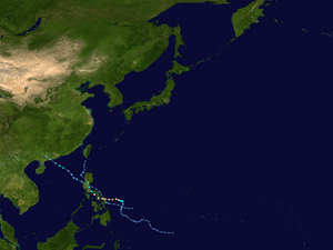 Season summary map | |
| Seasonal boundaries | |
| First system formed | May 10, 2020 |
| Last system dissipated | Season ongoing |
| Strongest storm | |
| Name | Vongfong |
| • Maximum winds | 155 km/h (100 mph) (10-minute sustained) |
| • Lowest pressure | 965 hPa (mbar) |
| Seasonal statistics | |
| Total depressions | 2 |
| Total storms | 2 |
| Typhoons | 1 |
| Total fatalities | 6 total |
| Total damage | $31.1 million (2020 USD) |
| Related articles | |
| |
The season’s first named storm, Vongfong (Ambo), developed east of Mindanao and rapidly intensified to become a Category 3 typhoon at peak intensity, undergoing an eyewall replacement cycle and made landfall on Samar Island, causing US$31.1 million damage to the country.
The scope of this article is limited to the Pacific Ocean to the north of the equator between 100°E and 180th meridian. Within the northwestern Pacific Ocean, there are two separate agencies that assign names to tropical cyclones which can often result in a cyclone having two names. The Japan Meteorological Agency (JMA) will name a tropical cyclone should it be judged to have 10-minute sustained wind speeds of at least 65 km/h (40 mph) anywhere in the basin, whilst the Philippine Atmospheric, Geophysical and Astronomical Services Administration (PAGASA) assigns names to tropical cyclones which move into or form as a tropical depression in their area of responsibility located between 135°E and 115°E and between 5°N–25°N regardless of whether or not a tropical cyclone has already been given a name by the JMA. Tropical depressions that are monitored by the United States' Joint Typhoon Warning Center (JTWC) are given a number with a "W" suffix.
Seasonal forecasts
| TSR forecasts Date | Tropical storms | Total Typhoons | Intense TCs | ACE | Ref. |
|---|---|---|---|---|---|
| Average (1965–2019) | 26 | 16 | 9 | 294 | [1] |
| May 21, 2020 | 26 | 15 | 8 | 258 | [1] |
| Other forecasts Date | Forecast Center | Period | Systems | Ref. | |
| January 22, 2020 | PAGASA | January–March | 0–4 tropical cyclones | [2] | |
| January 22, 2020 | PAGASA | April–June | 2–5 tropical cyclones | [2] | |
| 2020 season | Forecast Center | Tropical cyclones | Tropical storms | Typhoons | Ref. |
| Actual activity: | JMA | 2 | 2 | 1 | |
| Actual activity: | JTWC | 2 | 2 | 1 | |
| Actual activity: | PAGASA | 2 | 2 | 1 | |
During the year several national meteorological services and scientific agencies forecast how many tropical cyclones, tropical storms, and typhoons will form during a season and/or how many tropical cyclones will affect a particular country. These agencies include the Tropical Storm Risk (TSR) Consortium of University College London, PAGASA and Taiwan's Central Weather Bureau. The first forecast for the year was released by PAGASA on January 22 predicting the first half of 2020, within its monthly seasonal climate outlook.[2] The PAGASA predicts that only 0-4 tropical cyclones are expected to form or enter the Philippine Area of Responsibility between January and March, while five to eight tropical cyclones are expected to form between April and June. This was due to the fact that the El Niño–Southern Oscillation was seeing neutral conditions across the Pacific, and could persist until midyear.[2] On May 21, the TSR issued their extended-range forecast for 2020, forecasting tropical activity below the average normal, with 26 tropical storms, 15 typhoons and 8 intense typhoons.[1] These numbers were supported by the current values from the Indian Ocean Dipole, the Accumulated Cyclone Energy index and the sea-surface temperatures in the Niño 3.75 region, leading to a stronger than normal trade windspeed throughout much of the Western Pacific.[1]
Season summary

The first few months of 2020 were extremely quiet, with no tropical systems developing between the months of January and April. On May 10, the season saw its first tropical system with the development of Tropical Depression 01W (Ambo), making it the sixth-latest starting season on record, as well as the latest since 2016. Two days later, the system strengthened to the first officially named tropical storm of the season, Vongfong. Tropical Storm Vongfong then intensified immediately into a significant typhoon and struck the central part of the Philippines on May 14, first making its landfall in San Policarpo, Eastern Samar, crossing 4 more islands and hit mainland Luzon.
After Vongfong, a month of inactivity ensued, and on June 10, a new tropical depression formed off the coast of Samar, Philippines, and was named Butchoy by the PAGASA a day later. Butchoy made landfall in the Philippines as the JTWC issued a TCFA for it. Once it exited Philippine landmass, Butchoy was upgraded into a tropical depression by the JTWC and all warnings issued by PAGASA was lowered, and Butchoy further intensified into a tropical storm in the West Philippine Sea and was named Nuri by the Japan Meteorological Agency.
Systems
Typhoon Vongfong (Ambo)
| Typhoon (JMA) | |
| Category 3 typhoon (SSHWS) | |
  | |
| Duration | May 10 – May 18 |
|---|---|
| Peak intensity | 155 km/h (100 mph) (10-min) 965 hPa (mbar) |
After 4 consecutive months of inactivity in the Western Pacific basin, a low-pressure area was first noted on May 9 by the JTWC near Micronesia and was given a medium chance of developing into a tropical cyclone. The following day, the JMA declared that it had developed into a tropical depression to the east of Mindanao, Philippines and was expected to slowly move west. The JTWC then issued a Tropical Cyclone Formation Alert (TCFA) for the embryonic system just hours later while convection began to gradually obscure the center. Later that day, the PAGASA followed suit and upgraded the system to a tropical depression, assigning it the name Ambo, as it became the first tropical cyclone to enter their area of responsibility for 2020.[3][4] The system began to slowly drift westwards throughout the proceeding days,[5] gradually intensifying with occasional convective bursts occurring near the slightly elongated circulation. On the next day, the JTWC upgraded Ambo into a tropical depression, designating it as 01W.[6] The storm gradually intensified throughout the day, as signified by a well-defined rain band developing on the northwestern side, and began to turn north. At this time, the JMA upgraded 01W to a tropical storm and assigned it the first name of the year, Vongfong.[7] Shortly after, the JTWC followed and upgraded the system to tropical storm intensity.[8] Utilizing favorable conditions with low wind shear, 29-30 °C waters, and excellent outflow, Vongfong began to rapidly intensify by early May 13.[9] Shortly after, the JMA upgraded the system to a severe tropical storm. Soon after, the JTWC upgraded the storm to a Category 1 typhoon with 1-minute sustained winds of 130 km/h (80 mph) as the structure quickly improved. The PAGASA and JMA would then upgrade the system to a typhoon later in the day,[9] with the JTWC quickly upgrading the system to a Category 2 typhoon as the eye became clearer. A few hours later, Vongfong intensified to a category 3-equivalent typhoon.[10] Vongfong made an eyewall replacement cycle and weakened back into a Category 2 typhoon. Typhoon Vongfong quickly finished its eyewall replacement cycle and re-intensified back into a Category 3 typhoon east of Samar Island. At 12:15 pm PST on May 14, Vongfong made its first landfall in San Policarpo, Eastern Samar.[11] Vongfong gradually weakened shortly after, crossing over the Ticao Pass as it moved further inland near Sorsogon.[12] By the succeeding day, PAGASA recorded five more landfalls: hitting the islands of Dalupiri Island, Capul Island, Ticao Island, Burias Island, and San Andres, Quezon in Luzon Island's Bondoc Peninsula.[13] Ambo weakened into a Category 1 storm due to these multiple landfalls. The system further weakened on May 15, and was downgraded by both the JMA and PAGASA to a severe tropical storm,[14] with the JTWC downgrading it to a tropical storm as well. Severe Tropical Storm Vongfong then brought heavy rains and winds to the capital Metro Manila and other areas in Luzon. Then, Severe Tropical Storm Vongfong made its 7th landfall in Real, Quezon, and began to head further inland into Luzon, particularly Bulacan, continuing to deliver very heavy rainfall across the entirety of Central Luzon.[15][16] Severe Tropical Storm Vongfong further weakened and was downgraded by the JMA and the PAGASA into a tropical storm while it was inland Luzon. The weakening trend continued, and by May 16, Vongfong exited the landmass of Luzon into the waters of the West Philippine Sea, west of Ilocos Sur. After hitting many places in the Philippines, Tropical Storm Vongfong weakened into a low end-tropical storm. The JTWC then downgraded Vongfong into a tropical depression, and soon after that, they issued their final warning on the system, despite the JMA keeping it as a tropical storm. The PAGASA also downgraded Vongfong to a tropical depression, as Vongfong became very disorganized, and very damaged by the Luzon landmass. Soon, the agencies gave their final warning on Vongfong, as its low-level circulation center (LLCC) became exposed in the Luzon Strait.
In preparation for the incoming Typhoon Vongfong, Tropical Cyclone Wind Signal (TCWS) #3 warnings were issued for Northern Samar and the northern portion of Eastern Samar.[17] According to the NDRRMC, Typhoon Vongfong (Ambo) left ₱1.57 billion (US$31.1 million) worth of damages in agriculture, and left five dead, as of May 27.[18][19]
Tropical Storm Nuri (Butchoy)
| Tropical storm (JMA) | |
| Tropical storm (SSHWS) | |
  | |
| Duration | June 10 – June 14 |
|---|---|
| Peak intensity | 75 km/h (45 mph) (10-min) 996 hPa (mbar) |
On June 10, the JMA began monitoring on a weak tropical depression that had developed to the east of the Philippine island of Samar in Visayas. During the next day, the PAGASA began tracking the system, giving the local name Butchoy.[20][21]According to PAGASA, Tropical Depression Butchoy then made its first landfall in Polillo Island in Quezon at 5:30pm PHT, and making its second landfall in Infanta, Quezon shortly thereafter. Soon after, the JTWC issued a Tropical Cyclone Formation Alert (TCFA) for Butchoy. The storm caused widespread flooding across the Philippines as it passed the Luzon landmass and enhanced the southwest monsoon. Soon afterward, the JTWC officially upgraded Butchoy to a tropical depression, and designated it 02W. As 02W (Butchoy) exited the Philippine landmass, the PAGASA lowered all TCWS warnings over the country. Butchoy then started to intensify in the West Philippine Sea, later becoming a tropical storm and receiving the name Nuri from the JMA on June 12. Then, the PAGASA issued their final warning on Butchoy (Nuri) as it exited the Philippine Area of Responsibility. Nuri then intensified further in the South China Sea, with the JMA analysing the storm's winds of 75 km/h (45 mph). By June 13, the JTWC upgraded Nuri to a tropical storm. However by the next day, both the JMA and JTWC downgraded Nuri back to a tropical depression, where the JMA issued their final warning on the system, shortly before making landfall near Yangjiang. The JTWC issued their final warning for Nuri several hours later.[22]
The PAGASA issued Tropical Cyclone Signal No. 1 for western Mindanao, southern Luzon, and Visayas on June 11 as Butchoy neared the Philippines.[23] The combination of the system and prevailing southwesterly winds brought showers and thunderstorms across the Philippines.[24] Heavy rainfall in Albay led to the activation of disaster risk management officials and other emergency assets.[23] The rains from the tropical depression prompted PAGASA to declare the start of the rainy season in the Philippines on June 12, 2020, which was also during the country's Independence Day.[25][26]
In Hong Kong, Nuri brought heavy rain. One person also drowned due to flooding.[27]
Storm names
Within the Northwest Pacific Ocean, both the Japan Meteorological Agency (JMA) and the Philippine Atmospheric, Geophysical and Astronomical Services Administration (PAGASA) assign names to tropical cyclones that develop in the Western Pacific, which can result in a tropical cyclone having two names.[28] The Japan Meteorological Agency's RSMC Tokyo — Typhoon Center assigns international names to tropical cyclones on behalf of the World Meteorological Organization's Typhoon Committee, should they be judged to have 10-minute sustained windspeeds of 65 km/h (40 mph).[29] PAGASA names to tropical cyclones which move into or form as a tropical depression in their area of responsibility located between 135°E and 115°E and between 5°N and 25°N even if the cyclone has had an international name assigned to it.[28] The names of significant tropical cyclones are retired, by both PAGASA and the Typhoon Committee.[29] Should the list of names for the Philippine region be exhausted then names will be taken from an auxiliary list of which the first ten are published each season. Unused names are marked in gray.
International names
A tropical cyclone is named when it is judged to have 10-minute sustained windspeeds of 65 km/h (40 mph).[30] The JMA selected the names from a list of 140 names, that had been developed by the 14 members nations and territories of the ESCAP/WMO Typhoon Committee.[31] Retired names, if any, will be announced by the WMO in 2021; replacement names will be announced in 2022. The next 28 names on the naming list are listed here along with their international numeric designation, if they are used.
|
|
|
|
Philippines
This season, PAGASA will use its own naming scheme for storms that will either develop within or move into their self-defined area of responsibility.[32] The names are taken from a list of names that were last used during 2016 and are scheduled to be used again during 2024.[32] All of the names are the same except Kristine, Leon, and Nika, which replaced the names Karen, Lawin, and Nina after they were retired.[32]
|
|
|
|
|
Auxiliary list
|
|
|
|
|
Season effects
This table summarizes all the systems that developed within or moved into the North Pacific Ocean, to the west of the International Date Line during 2020. The tables also provide an overview of a system's intensity, duration, land areas affected and any deaths or damages associated with the system.
| Name | Dates active | Peak classification | Sustained wind speeds |
Pressure | Areas affected | Damage (USD) |
Deaths | Refs |
|---|---|---|---|---|---|---|---|---|
| Vongfong (Ambo) | May 10 – 18 | Typhoon | 155 km/h (100 mph) | 965 hPa (28.50 inHg) | Palau, Philippines, Taiwan | $31.1 million | 5 | [18][19] |
| Nuri (Butchoy) | June 10 – 14 | Tropical storm | 75 km/h (45 mph) | 996 hPa (29.41 inHg) | Philippines, South China | Unknown | 1 | [27] |
| Season aggregates | ||||||||
| 2 systems | May 10 – Season ongoing | 155 km/h (100 mph) | 965 hPa (28.50 inHg) | $31.1 million | 6 | |||
See also
- Tropical cyclones in 2020
- Pacific typhoon season
- 2020 Atlantic hurricane season
- 2020 Pacific hurricane season
- 2020 North Indian Ocean cyclone season
- South-West Indian Ocean cyclone seasons: 2019–20, 2020–21
- Australian region cyclone seasons: 2019–20, 2020–21
- South Pacific cyclone seasons: 2019–20, 2020–21
References
- Saunders, Mark; Lea, Adam (May 21, 2020). Extended Range Forecast for Northwest Pacific Typhoon Activity in 2020 (PDF) (Report). Tropical Storm Risk Consortium. Retrieved May 21, 2020.
- 121st Climate Forum March-August 2020 (PDF) (Seasonal Climate Outlook). Philippine Atmospheric Geophysical and Astronomical Services Administration. January 22, 2020. Archived from the original (PDF) on July 16, 2019. Retrieved March 13, 2020.
- "First storm this year to hit Mindanao, PAGASA says". CNN Philippines. May 10, 2020. Retrieved May 13, 2020.
- "Severe Weather Bulletin #1 for Tropical Depression "Ambo"" (PDF). Philippine Atmospheric, Geophysical and Astronomical Services Administration. May 10, 2020. Retrieved May 13, 2020.
- "Severe Weather Bulletin #3 for Tropical Depression "Ambo"" (PDF). Philippine Atmospheric, Geophysical and Astronomical Services Administration. Retrieved May 12, 2020.
- "Tropical Depression 01W Warning Nr 1". Joint Typhoon Warning Center. April 12, 2020. Archived from the original on April 12, 2020.
- Shu-fen, Wang; Hsin-Yin, Lee (May 12, 2020). "Tropical Storm Vongfong likely to approach Taiwan over weekend: CWB". Focus Taiwan.
- "Tropical Storm 01W (Vongfong) Warning Nr 004". Joint Typhoon Warning Center. May 12, 2020. Archived from the original on May 12, 2020.
- "Severe Weather Bulletin #10 - Typhoon "AMBO" (VONGFONG)" (PDF). Philippine Atmospheric, Geophysical and Astronomical Services Administration.
- "Typhoon 01W (Vongfong) Warning Nr 009". Joint Typhoon Warning Center. May 13, 2020. Archived from the original on May 13, 2020.
- "Severe Weather Bulletin #14 for Typhoon "Ambo" (Vongfong)" (PDF). Philippine Atmospheric, Geophysical and Astronomical Services Administration. May 14, 2020.
- "Severe Weather Bulletin #17 - Typhoon "AMBO" (VONGFONG)" (PDF). Philippine Atmospheric, Geophysical and Astronomical Services Administration. Retrieved May 14, 2020.
- "Severe Weather Bulletin #20 for Typhoon "Ambo" (Vongfong)" (PDF). Philippine Atmospheric, Geophysical and Astronomical Services Administration. May 15, 2020. Retrieved May 15, 2020.
- "Severe Weather Bulletin #22 for Severe Tropical Storm "Ambo" (Vongfong)" (PDF). Philippine Atmospheric, Geophysical and Astronomical Services Administration. May 15, 2020. Retrieved May 15, 2020.
- "Severe Weather Bulletin #25 - Severe Tropical Storm "AMBO" (VONGFONG)" (PDF). Philippine Atmospheric, Geophysical and Astronomical Services Administration. Retrieved May 15, 2020.
- "Severe Tropical Storm Vongfong Takes Aim at Philippine Heartland" (May 15, 2020). The New York Times. Retrieved May 15, 2020.
- "Severe Weather Bulletin #11 - Typhoon "AMBO" (VONGFONG)" (PDF). Philippine Atmospheric, Geophysical and Astronomical Services Administration. Retrieved May 14, 2020.
- "Sitrep No.15 re Preparedness Measures and Effects for Typhoon "AMBO" (I.N. "VONGFONG")" (PDF). NDRRMC. May 27, 2020.
- "5 dead, P80 million lost in Typhoon 'Ambo' wake". Manila Standard. May 18, 2020.
- "PAGASA-DOST on Twitter". Twitter. Retrieved 2020-06-11.
- http://pubfiles.pagasa.dost.gov.ph/tamss/weather/bulletin/SWB%231.pdf
- Update, JTWC (13 June 2020). "JTWC upgraded Nuri to a Tropical storm". Joint Typhoon Warning Center. Archived from the original on 13 June 2020. Retrieved 13 June 2020.
- "Tropical depression Butchoy makes landfall in Quezon". CNN Philippines. Manila, Philippines. Cable News Network. June 11, 2020. Retrieved June 11, 2020.
- Arayata, Cristina (June 11, 2020). "LPA may become tropical depression Thursday: PAGASA". Philippine News Agency. Manila, Philippines: Philippine News Agency. Retrieved June 11, 2020.
- Acor Arceo (June 12, 2020). "PAGASA declares start of rainy season in the Philippines". Rappler. Retrieved June 12, 2020.
- Jamaine Punzalan (June 12, 2020). "Rainy season is here, PAGASA says as 'Butchoy' dampens Independence Day". ABS-CBN News. Retrieved June 12, 2020.
- Maisy Mok (June 15, 2020). "One drowning as first storm goes by". The Standard.
- Padgett, Gary. "Monthly Tropical Cyclone Summary December 1999". Australian Severe Weather. Archived from the original on August 28, 2012. Retrieved October 1, 2013.
- The Typhoon Committee (February 21, 2013). "Typhoon Committee Operational Manual 2013". World Meteorological Organization. pp. 37–38. Archived from the original (PDF) on August 28, 2012. Retrieved October 1, 2013.
- "1REVIEW OF THE 2015TYPHOON SEASON" (PDF). typhooncommittee.org. 2016. Retrieved 2019-12-11. Cite journal requires
|journal=(help) - Zhou, Xiao; Lei, Xiaotu (2012). "Summary of retired typhoons within the Western North Pacific Ocean". Tropical Cyclone Research and Review. The Economic and Social Commission for Asia and the Pacific/World Meteorological Organization's Typhoon Committee. 1 (1): 23–32. doi:10.6057/2012TCRR01.03. ISSN 2225-6032. Archived from the original on August 12, 2017. Retrieved December 21, 2014.
- "Philippine Tropical Cyclone Names". Philippine Atmospheric, Geophysical and Astronomical Services Administration. Archived from the original on December 28, 2016. Retrieved April 18, 2015.
External links
| Wikimedia Commons has media related to 2020 Pacific typhoon season. |
- China Meteorological Agency
- Digital Typhoon
- Hong Kong Observatory
- Japan Meteorological Agency
- Joint Typhoon Warning Center
- Korea Meteorological Administration
- Malaysian Meteorological Department
- National Weather Service Guam
- Philippine Atmospheric, Geophysical and Astronomical Services Administration
- Taiwan Central Weather Bureau
- TCWC Jakarta (in Indonesian)
- Thai Meteorological Department (in Thai)
- Typhoon2000
- Vietnam's National Hydro-Meteorological Service
Tropical cyclones of the 2020 Pacific typhoon season | ||
|---|---|---|
Timeline | ||
| ||
| ||