San Antonio, Northern Samar
San Antonio, officially the Municipality of San Antonio, is a 5th class municipality in the province of Northern Samar, Philippines. According to the 2015 census, it has a population of 9,058 people.[3]
San Antonio Dalupiri | |
|---|---|
| Municipality of San Antonio | |
 Dalupiri Island | |
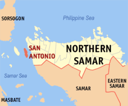 Map of Northern Samar with San Antonio highlighted | |
| |
.svg.png) San Antonio Location within the Philippines | |
| Coordinates: 12°25′N 124°16′E | |
| Country | |
| Region | Eastern Visayas (Region VIII) |
| Province | Northern Samar |
| District | 1st District |
| Founded | 1904 |
| Barangays | 10 (see Barangays) |
| Government | |
| • Type | Sangguniang Bayan |
| • Mayor | Manuel M. Esponilla |
| • Vice Mayor | Rudy S. Baguioso |
| • Congressman | Paul R. Daza |
| • Municipal Council | Councilors
|
| • Electorate | 6,933 voters (2019) |
| Area | |
| • Total | 27.00 km2 (10.42 sq mi) |
| Elevation | 3.8 m (12.5 ft) |
| Population (2015 census)[3] | |
| • Total | 9,058 |
| • Density | 340/km2 (870/sq mi) |
| • Households | 1,873 |
| Economy | |
| • Income class | 5th municipal income class |
| • Poverty incidence | 43.19% (2015)[4] |
| • Revenue (₱) | 41,899,131.33 (2016) |
| Time zone | UTC+8 (PST) |
| ZIP code | 6407 |
| PSGC | |
| IDD : area code | +63 (0)55 |
| Climate type | tropical rainforest climate |
| Native languages | Cebuano Waray Tagalog |
| Website | www |
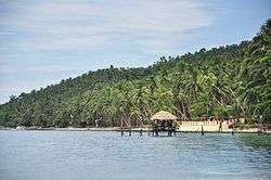
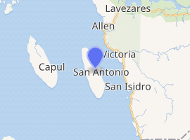
Its territory is coterminous with Dalupiri Island, just off the western coast of Samar Island at the south end of the San Bernardino Strait. The island's white beaches are considered an "undisturbed paradise" and future "premier tourist destination" in the Eastern Visayas region.[5] San Antonio is also unique, as it is the only municipality in Northern Samar which predominantly speaks Cebuano due to the influx of Boholano and Cebuano settlers in the past. There is a sizable Waray-speaking population present in the island though.
Geography
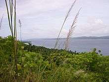
Dalupiri Island lies in the east central periphery of the Philippine archipelago. It is bounded by San Bernardino Strait in the north and east, Samar Sea in the south, and Capul Island in west. It is approximately 5 nautical miles from the Pacific Ocean and sits near the entrance along the Paso de Acapulco, otherwise known as San Bernardino Strait. It has 28 kilometres (17 mi) long white sand beach around the island.
Dalupiri Island is a 2,700 hectare island of gently rolling hills, mostly of coconut vegetation and shrubbery. It is home to white beaches, caves, and the Lagbangan Lake.
Topography
The island is composed largely of low and extremely rugged hills and small lowland areas. The island is endowed with relatively rich and fertile soil that allow most crops to be cultivated, but presently it is utilized mostly for coconut plantations.
The highest point of the island is in its central southern portion with a maximum elevation of 35 metres (115 ft) above sea level.
Climate
The island has no distinct dry or wet season but it has pronounced rainfall from October to January. The heaviest precipitation occurs in November. May is relatively the driest month.
| Climate data for San Antonio, Northern Samar | |||||||||||||
|---|---|---|---|---|---|---|---|---|---|---|---|---|---|
| Month | Jan | Feb | Mar | Apr | May | Jun | Jul | Aug | Sep | Oct | Nov | Dec | Year |
| Average high °C (°F) | 27 (81) |
28 (82) |
29 (84) |
30 (86) |
31 (88) |
30 (86) |
29 (84) |
29 (84) |
29 (84) |
29 (84) |
29 (84) |
28 (82) |
29 (84) |
| Average low °C (°F) | 22 (72) |
22 (72) |
22 (72) |
22 (72) |
24 (75) |
24 (75) |
24 (75) |
24 (75) |
24 (75) |
24 (75) |
23 (73) |
23 (73) |
23 (74) |
| Average precipitation mm (inches) | 84 (3.3) |
59 (2.3) |
58 (2.3) |
55 (2.2) |
93 (3.7) |
133 (5.2) |
149 (5.9) |
125 (4.9) |
155 (6.1) |
165 (6.5) |
140 (5.5) |
136 (5.4) |
1,352 (53.3) |
| Average rainy days | 18.1 | 13.6 | 15.8 | 16.1 | 21.7 | 25.5 | 26.6 | 25.1 | 24.8 | 25.8 | 22.7 | 20.1 | 255.9 |
| Source: Meteoblue [6] | |||||||||||||
Barangays
San Antonio is composed of ten barangays (listed here with 2010 population):
- Burabod - 936
- Dalupirit - 1,864
- Manraya - 813
- Pilar - 683
- Rizal - 376
- San Nicolas - 517
- Vinisitahan - 664
- Ward I (Poblacion) - 745
- Ward II (Poblacion) - 759
- Ward III (Poblacion) - 1,520
The town center (poblacion) is divided into three small barangays: Poblacion Ward I, Poblacion Ward II, and Poblacion Ward III.
Barangay San Nicolas, named after its patron Saint Nicolas, is home to picturesque rock formation along the coast. Barangay Rizal is home to a solar spring and cave. Barangay Pilar is the southernmost tip of the island where a fish sanctuary is located. This is the home of palatable seashells and other seafood.
Barangay Burabod's major livelihood is boat-building, fishing, copra and dynamite blasting cap manufacturing.
Demographics
| Population census of San Antonio | ||
|---|---|---|
| Year | Pop. | ±% p.a. |
| 1903 | 2,059 | — |
| 1918 | 3,994 | +4.52% |
| 1939 | 6,421 | +2.29% |
| 1948 | 6,781 | +0.61% |
| 1960 | 5,898 | −1.16% |
| 1970 | 6,291 | +0.65% |
| 1975 | 7,250 | +2.89% |
| 1980 | 7,008 | −0.68% |
| 1990 | 7,164 | +0.22% |
| 1995 | 7,984 | +2.05% |
| 2000 | 7,915 | −0.19% |
| 2007 | 8,151 | +0.41% |
| 2010 | 8,877 | +3.15% |
| 2015 | 9,058 | +0.39% |
| Source: Philippine Statistics Authority[3][7][8][9] | ||
History
In the early 19th century the settlers from the mainland of Samar found the island an ideal ground for fishing and bird hunting. They come to the island just to catch fish and hunt birds and go back to the mainland of Samar after a handful of catch. People from Bohol and Cebu came to the island in the second half of the 19th century and introduced a method of catching fish using net, commonly known as "laya". With its introduction, the name "Manoglaya" was born, which literally means mano nga paraglaya or "fishermen using laya".
As new settlers came and built new communities in the island, they called the island as "Sugod-sugod", a Cebuano derivative meaning "just to start or begin". Later, name was changed to "Matabia", referring to the knife-shape of the island. No one knows now why it was changed that way, neither folklores nor historical data reveal the ways and wherefore of the change of its name to Dalupiri Island.
In 1904, the Municipality of San Antonio of the province of Samar in Dalupiri Island was established. The Municipality of San Antonio named after its patron saint Anthony of Padua.
Economy
San Antonio is one of the manufacturing centers of dynamite chemicals like ammonium nitrate, used in the manufacture of blasting caps that are sold in the other provinces of Samar island. It was learned that the island has been tagged by the police as one of the areas in the manufacture of the dynamite blasting caps.
Chief Supt. Abner Cabalquinto, Regional VIII Police Director, disclosed that the police operatives in Northern Samar confiscated 50 bags of ammonium nitrate in the town of San Antonio. However, the suspects were able to escape and alluded arrest by the police.[10]
Because of the prevalence of homemade dynamite, blast fishing is a perennial problem in the region.[11] In 1994, an Italian tourist was killed and another severely injured while diving when a local fisherman dropped his dynamite on top of them. As a result, the Flying Dog Beach Resort, established in the early 1990s, decided to cease its operation.[12][13]
The Dalupiri Ocean Power Plant is a proposed tidal fence generating station across the Dalupiri Passage between the islands of Dalupiri and Samar.[14]
Tourism
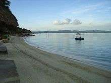
Because of Dalupiri Island's pristine white sand beach, Republic Act No. 9458 declared San Antonio, together with the island towns of Biri, Capul, and San Vicente, as eco-tourism zones in May 2007.[15]
With its coral reefs, Dalupiri island is ideal for scuba diving, snorkeling, sailing, yachting, jet skiing, para-sailing and marine life observation.
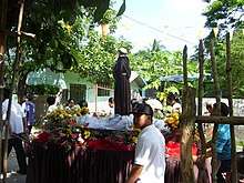
Manoglaya Festival
A cultural-tourism festival held in the town of San Antonio from the 9th to the 12th of June annually, celebrating the fishing skills of the townfolks. The festival composed of cultural performances, street dance, beauty search and exhibit complemented with “sugod-sugod sa plaza”, a nightly entertainment of music and other performances from leading local performers in the community.
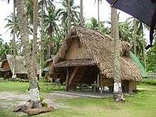
Beach Resorts
- Flying Dog Beach Resort - the first foreign operated resort on the island, established in the early 1990s, but now closed after an Italian tourist was killed in a dynamite blast in the diving site.
- Haven of Fun Beach Resort
- Puro Beach Resort
- Seashore Spring Beach Resort
- Crystal Sand Beach Resort
- Francisco Beach Resort
- Island beach resort
Transportation
Airport
Dalupiri Airport, also known as San Antonio Airport, is an airstrip in San Antonio in the Eastern Visayas region of Philippines. Its construction was approved by the Senate and House of Representatives of the Philippines on August 8, 2004.[16] This airport is still under constructions and not yet operational to the general public, local resident and Island tourist.
Seaport
San Antonio town proper Seaport the central part of the island premier gateway to the seaport of the town of Victoria. This two seaports are the busiest port connecting the Island and the mainland of Samar, providing main transport system to the island tourist and local resident.
There are also several seaport in the nearby barangay that also the gateway of the Island to the mainland land of Samar, in northern part of the island is the Vinisitahan Seaport and the western coast is the Dalupiri Seaport both to seaport in the town of Allen,Northern Samar and in the southern coast of the Island is the Burabod Seaport to the town of San Isidro, Northern Samar.
Land Transport System
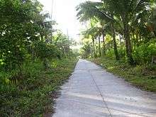
The main transportation going to the different part of the Island is the motorcycle where local called it as "honda" regardless of the manufacturer of the motorcycle. While going through the town proper there are several "padyak" as commonly called by the local residents; it is a bicycle driven cart.
Educational institutions
Private schools
- Pearl Island Academy
- Spring View Adventist Academy
Public schools
Secondary school:
- San Antonio Agricultural and Vocational School
Elementary schools:
- San Antonio Central Elementary School
- Vinisitahan Elementary School
- Dalupirit Elementary School
- San Nicolas Elementary School
- Rizal Elementary School
- Manraya Elementary School
- Pilar Elementary School
- Burabod Elementary School
Health Care
- San Antonio District Hospital
- Municipal Health Center
- Barangay Health Center
References
- "Municipality". Quezon City, Philippines: Department of the Interior and Local Government. Retrieved 31 May 2013.
- "Province: Northern Samar". PSGC Interactive. Quezon City, Philippines: Philippine Statistics Authority. Retrieved 12 November 2016.
- Census of Population (2015). "Region VIII (Eastern Visayas)". Total Population by Province, City, Municipality and Barangay. PSA. Retrieved 20 June 2016.
- "PSA releases the 2015 Municipal and City Level Poverty Estimates". Quezon City, Philippines. Retrieved 12 October 2019.
- Vicente S. Labro (26 August 2011). "Northern Samar offers undisturbed paradise islets". Inquirer News. Retrieved 15 April 2013.
- "San Antonio, Northern Samar : Average Temperatures and Rainfall". Meteoblue. Retrieved 6 January 2019.
- Census of Population and Housing (2010). "Region VIII (Eastern Visayas)". Total Population by Province, City, Municipality and Barangay. NSO. Retrieved 29 June 2016.
- Censuses of Population (1903–2007). "Region VIII (Eastern Visayas)". Table 1. Population Enumerated in Various Censuses by Province/Highly Urbanized City: 1903 to 2007. NSO.
- "Province of Northern Samar". Municipality Population Data. Local Water Utilities Administration Research Division. Retrieved 17 December 2016.
- . Manila Bulletin. Retrieved on 2012-09-16
- . Dynamite Fishing in San Antonio. Retrieved on 2012-09-16
- . Yahoo Group. Retrieved on 2012-09-16
- Judah S. Aliposa. Why Blast Fishing thrives in Samar. San Antonio Northern Samar. Retrieved on 2012-09-16
- "Tidal Fences". Wave and tidal power. Fujita Research. July 2000. Retrieved 15 April 2013.
- AN ACT DECLARING THE ISLAND-TOWNS OF BIRI, CAPUL, SAN ANTONIO AND SAN VICENTE, ALL IN THE PROVINCE OF NORTHERN SAMAR AS ECO-TOURISM ZONES. Philippine Congress. Approved May 15, 2007. Retrieved on 2013-04-15
- The LawPhil Project: RA 9330 AN ACT ESTABLISHING THE SAN ANTONIO AIRPORT IN THE ISLAND-MUNICIPALITY OF SAN ANTONIO, PROVINCE OF NORTHERN SAMAR AND APPROPRIATING FUNDS THEREFOR. Retrieved on 2012-09-22
External links
| Wikimedia Commons has media related to San Antonio, Northern Samar. |
- San Antonio Profile at PhilAtlas.com
- Philippine Standard Geographic Code
- Philippine Census Information
- Local Governance Performance Management System
- Facebook: https://www.facebook.com/SanAntonioNorthernSamar
Places adjacent to San Antonio, Northern Samar | ||||||||||
|---|---|---|---|---|---|---|---|---|---|---|
| ||||||||||