1st parallel south

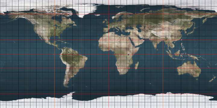
The 1st parallel south is a circle of latitude that is 1 degree south of the Earth's equatorial plane. It crosses the Atlantic Ocean, Africa, the Indian Ocean, Southeast Asia, Australasia, the Pacific Ocean and South America.

1st parallel south
The 1st parallel south forms most of Tanzania's northern border with Uganda, and a short section of its border with Kenya.

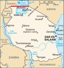
The parallel defines most of the border between Uganda and Tanzania, and a very short section of the border between Kenya and Tanzania.

Around the world

Starting at the Prime Meridian and heading eastwards, the parallel 1° south passes through:

Co-ordinates Country, territory or sea Notes
1°0′S 0°0′E Atlantic Ocean
1°0′S 8°52′E  Gabon
1°0′S 14°25′E  Republic of the Congo
1°0′S 17°20′E  Democratic Republic of the Congo
1°0′S 29°35′E  Uganda
1°0′S 30°45′E  Uganda /  Tanzania border Mostly in Lake Victoria
1°0′S 33°56′E  Kenya /  Tanzania border A short section of the border (about 11 km), entirely within Lake Victoria
1°0′S 34°1′E  Kenya Passing about 30 km north of the capital, Nairobi
1°0′S 41°7′E  Somalia
1°0′S 42°2′E Indian Ocean Passing just south of Addu Atoll,  Maldives
1°0′S 98°39′E  Indonesia Island of Siberut
1°0′S 98°56′E Mentawai Strait
1°0′S 100°21′E  Indonesia Island of Sumatra
1°0′S 103°59′E Karimata Strait
1°0′S 109°27′E  Indonesia Islands of Maya Karimata and Borneo
West Kalimantan
Central Kalimantan
East Kalimantan
Future capital of Indonesia
1°0′S 117°8′E Makassar Strait
1°0′S 119°28′E  Indonesia Island of Sulawesi
1°0′S 120°30′E Gulf of Tomini
1°0′S 121°23′E  Indonesia Island of Sulawesi
1°0′S 122°47′E Banda Sea
1°0′S 123°12′E  Indonesia Island of Sulawesi
1°0′S 123°22′E Molucca Sea
1°0′S 128°19′E  Indonesia Island of Damar
1°0′S 128°24′E Halmahera Sea
1°0′S 130°38′E  Indonesia Islands of Salawati and New Guinea
1°0′S 134°3′E Cenderawasih Bay
1°0′S 134°48′E  Indonesia Island of Noemfoor
1°0′S 134°57′E Cenderawasih Bay
1°0′S 135°48′E  Indonesia Island of Biak
1°0′S 136°8′E Pacific Ocean Passing just north of the atolls of Pelleluhu and Heina,  Papua New Guinea
Passing just south of the Kaniet Islands,  Papua New Guinea
Passing just south of Banaba Island,  Kiribati
Passing between the atolls of Nonouti and Tabiteuea,  Kiribati
1°0′S 91°26′W  Ecuador Island of Isabela
1°0′S 91°4′W Pacific Ocean Passing just south of the island of San Cristóbal,  Ecuador
1°0′S 80°51′W  Ecuador
1°0′S 75°23′W  Peru
1°0′S 74°16′W  Colombia
1°0′S 69°25′W  Brazil Amazonas
Roraima
Amazonas
Pará
Amapá
Maranhão
Pará - islands of Grande do Gurupá and Marajó, and the mainland
1°0′S 46°11′W Atlantic Ocean

See also

This article is issued from Wikipedia. The text is licensed under Creative Commons - Attribution - Sharealike. Additional terms may apply for the media files.