25th meridian east

The meridian 25° east of Greenwich is a line of longitude that extends from the North Pole across the Arctic Ocean, Europe, Africa, the Indian Ocean, the Southern Ocean, and Antarctica to the South Pole.

25°
25th meridian east
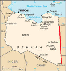
The 25th meridian east delineates most of Libya's eastern border with Egypt and Sudan

The 25th meridian east forms a great circle with the 155th meridian west.

Most of the border between Libya and Egypt is defined by the meridian, as is much of the border between Libya and Sudan.[1]

From Pole to Pole

Starting at the North Pole and heading south to the South Pole, the 25th meridian east passes through:

Co-ordinates Country, territory or sea Notes
90°0′N 25°0′E Arctic Ocean
80°15′N 25°0′E  Norway Island of Nordaustlandet, Svalbard
79°20′N 25°0′E Barents Sea
76°29′N 25°0′E  Norway Island of Hopen, Svalbard
76°26′N 25°0′E Barents Sea
71°2′N 25°0′E  Norway
68°37′N 25°0′E  Finland
65°38′N 25°0′E Baltic Sea Gulf of Bothnia
65°3′N 25°0′E  Finland Island of Hailuoto
65°2′N 25°0′E Baltic Sea Gulf of Bothnia
64°55′N 25°0′E  Finland Passing through Helsinki
60°10′N 25°0′E Baltic Sea Gulf of Finland
59°39′N 25°0′E  Estonia Island of Prangli
59°37′N 25°0′E Baltic Sea Gulf of Finland
59°29′N 25°0′E  Estonia Passing just east of Tallinn
58°0′N 25°0′E  Latvia
56°18′N 25°0′E  Lithuania
54°9′N 25°0′E  Belarus
51°55′N 25°0′E  Ukraine Volyn Oblast — passing just west of Lutsk
Lviv Oblast — passing just east of Zolochiv
Ternopil Oblast — passing just east of Berezhany
Ivano-Frankivsk Oblast — passing through Kolomyia
Chernivtsi Oblast
47°44′N 25°0′E  Romania
43°44′N 25°0′E  Bulgaria
41°23′N 25°0′E  Greece
40°57′N 25°0′E Mediterranean Sea Aegean Sea - passing just west of the island of Lemnos,  Greece
39°33′N 25°0′E  Greece Island of Agios Efstratios
39°29′N 25°0′E Mediterranean Sea Aegean Sea
37°46′N 25°0′E  Greece Just passing through the easternmost point of the island of Andros
37°46′N 25°0′E Mediterranean Sea Aegean Sea
37°40′N 25°0′E  Greece Island of Tinos
37°38′N 25°0′E Mediterranean Sea Aegean Sea - passing just east of the island of Syros,  Greece
36°59′N 25°0′E  Greece Island of Despotiko
36°57′N 25°0′E Mediterranean Sea Aegean Sea
Passing between the islands of Folegandros and Sikinos,  Greece
36°36′N 25°0′E Mediterranean Sea Sea of Crete
35°25′N 25°0′E  Greece Island of Crete
34°56′N 25°0′E Mediterranean Sea
31°57′N 25°0′E  Libya
31°30′N 25°0′E  Egypt
30°50′N 25°0′E  Libya For about 12 km
30°44′N 25°0′E  Egypt
29°15′N 25°0′E  Libya /  Egypt border
22°0′N 25°0′E  Libya /  Sudan border
20°0′N 25°0′E  Sudan
9°58′N 25°0′E  South Sudan
7°58′N 25°0′E  Central African Republic
5°0′N 25°0′E  Democratic Republic of the Congo
11°15′S 25°0′E  Zambia
17°36′S 25°0′E  Namibia Caprivi Strip
17°43′S 25°0′E  Botswana Passing through the Makgadikgadi Pan
25°45′S 25°0′E  South Africa North West
Northern Cape - for about 8 km
North West
Northern Cape - for about 8 km
Free State
Northern Cape
Eastern Cape
33°59′S 25°0′E Indian Ocean
60°0′S 25°0′E Southern Ocean
70°7′S 25°0′E Antarctica Queen Maud Land, claimed by  Norway

See also

References

  1. Brownlie, Ian (1979). African Boundaries: A Legal and Diplomatic Encyclopedia. Institute for International Affairs, Hurst and Co. pp. 102-09 & 133-40.


This article is issued from Wikipedia. The text is licensed under Creative Commons - Attribution - Sharealike. Additional terms may apply for the media files.