70th parallel north

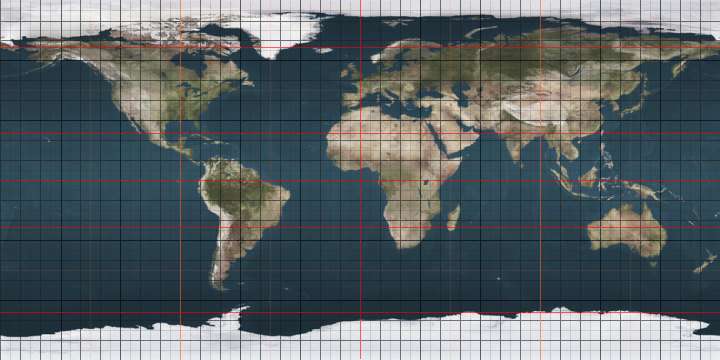
The 70th parallel north is a circle of latitude that is 70 degrees north of the Earth's equatorial plane, in the Arctic. It crosses the Atlantic Ocean, Europe, Asia and North America, and passes through some of the southern seas of the Arctic Ocean.

70°
70th parallel north
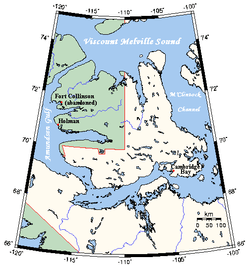
On Victoria Island, Canada, part of the border between Northwest Territories (green) and Nunavut (white) is defined by the 70th parallel north

At this latitude the sun is visible for 24 hours, 0 minutes during the summer solstice and Civil Twilight during the winter solstice.

On 21 June, the maximum altitude of the sun is 43.44 degrees and 3.44 degrees on 21 December.

Around the world

Starting at the Prime Meridian and heading eastwards, the parallel 70° north passes through:

Co-ordinates Country, territory or sea Notes
70°0′N 0°0′E Atlantic Ocean Norwegian Sea
70°0′N 18°40′E  Norway Troms - islands of Rebbenesøya, Ringvassøy, Reinøya, Karlsøya and Kågen; mainland; island of Skorpa; mainland
Finnmark (mainland)
70°0′N 27°22′E  Finland Passing about 10 km south of the northernmost point of Finland, which is located at 70°05.537′N 27°57.335′E in the village of Nuorgam
70°0′N 28°2′E  Norway Finnmark
70°0′N 29°30′E Barents Sea
70°0′N 58°44′E  Russia Vaygach Island
70°0′N 60°12′E Kara Sea
70°0′N 66°56′E  Russia Yamal Peninsula
70°0′N 72°30′E Gulf of Ob
70°0′N 73°45′E  Russia
70°0′N 159°53′E East Siberian Sea
70°0′N 168°13′E  Russia Ayon Island
70°0′N 168°31′E East Siberian Sea
70°0′N 170°35′E  Russia
70°0′N 171°48′E East Siberian Sea
70°0′N 177°56′E Chukchi Sea
70°0′N 162°27′W  United States Alaska
70°0′N 142°34′W Beaufort Sea
70°0′N 131°2′W  Canada Northwest Territories - Tuktoyaktuk Peninsula
70°0′N 129°30′W Beaufort Sea
70°0′N 128°18′W  Canada Northwest Territories - Cape Bathurst Peninsula
70°0′N 126°54′W Amundsen Gulf
70°0′N 125°12′W  Canada Northwest Territories - Parry Peninsula
70°0′N 124°30′W Amundsen Gulf
70°0′N 117°22′W  Canada On Victoria Island:
- Northwest Territories
- Northwest Territories / Nunavut border
- Northwest Territories
- Northwest Territories / Nunavut border
- Nunavut
70°0′N 100°48′W Victoria Strait
70°0′N 98°50′W Larsen Sound Passing just north of King William Island, Nunavut,  Canada
70°0′N 97°35′W James Ross Strait Passing just north of the Clarence Islands, Nunavut,  Canada
70°0′N 96°17′W  Canada Boothia Peninsula, Nunavut
70°0′N 92°1′W Gulf of Boothia
70°0′N 86°54′W  Canada Nunavut - Crown Prince Frederik Island
70°0′N 86°27′W Fury and Hecla Strait
70°0′N 84°20′W  Canada Nunavut - Baffin Island
70°0′N 81°9′W Murray Maxwell Bay
70°0′N 80°19′W  Canada Nunavut - Baffin Island
70°0′N 78°39′W Steensby Inlet
70°0′N 77°41′W  Canada Nunavut - Baffin Island
70°0′N 67°20′W Baffin Bay Northern limit of the Davis Strait
70°0′N 53°39′W  Greenland Disko Island
70°0′N 52°30′W Sullorsuaq Strait
70°0′N 51°28′W  Greenland Nuussuaq Peninsula
70°0′N 50°37′W Torsukattak Fjord
70°0′N 50°10′W  Greenland Sermeq Kujalleq
70°0′N 27°20′W Gaasefjord
70°0′N 25°15′W  Greenland Geikie Plateau
70°0′N 22°18′W Arctic Ocean Greenland Sea
Norwegian Sea

See also

This article is issued from Wikipedia. The text is licensed under Creative Commons - Attribution - Sharealike. Additional terms may apply for the media files.