1955 Great Plains tornado outbreak
The 1955 Great Plains tornado outbreak was a deadly tornado outbreak that struck the southern and central U.S Great Plains States on May 25–26, 1955. It produced at least 46 tornadoes across seven states including two F5 tornadoes in Blackwell, Oklahoma, and Udall, Kansas that caused most of the casualties. The outbreak killed 102 from three tornadoes while injuring hundreds more. Unusual electromagnetic activity was observed, including St. Elmo's fire.[1]
Part of the tornado outbreaks of 1955 | |
 Damage from the Udall Tornado | |
| Type | Tornado outbreak |
|---|---|
| Duration | May 25–26, 1955 |
| Tornadoes confirmed | 46 |
| Max. rating1 | F5 tornado |
| Duration of tornado outbreak2 | ~1¼ day |
| Damage | unknown |
| Casualties | 102 fatalities, hundreds injured |
| Areas affected | Central United States |
| 1Most severe tornado damage; see Fujita scale 2Time from first tornado to last tornado | |
Tornado table
| FU | F0 | F1 | F2 | F3 | F4 | F5 | Total |
|---|---|---|---|---|---|---|---|
| 0 | 11 | 17 | 13 | 3 | 1 | 2 | 46 |
May 25 event
| List of confirmed tornadoes — May 25, 1955 | ||||||
|---|---|---|---|---|---|---|
| Texas | ||||||
| F4 | SW of Aberdeen to S of Dempsey, OK | Collingsworth, Wheeler, Roger Mills (OK) | 2117 | 45.1 miles (72.6 km) | 2 deaths - 13 farm homes were destroyed, some of which were swept away. 100 cattle were killed and a car was carried 700 feet (0.13 mi). Damage $500,000 with F4 damage in both Texas and Oklahoma (Grazulis 1991). | |
| F0 | SE of Sterling City | Sterling | 0000 | 0.1 miles (160 m) | ||
| F1 | E of Rotan | Fisher | 0430 | 0.3 miles (480 m) | ||
| F2 | SW of Benjamin | Knox | 0530 | 11.9 miles (19.2 km) | Tornado destroyed a barn and also caused damage to two homes (Grazulis 1991). | |
| F2 | Wichita Falls area | Wichita | 0738 | 1.3 miles (2.1 km) | ||
| Oklahoma | ||||||
| F1 | E of Shattuck | Ellis | 0000 | 4.9 miles (7.9 km) | ||
| F1 | NE of Rush Springs | Grady | 0000 | 0.1 miles (160 m) | ||
| F0 | NE of Mayfield | Beckham | 0005 | 3.8 miles (6.1 km) | ||
| F1 | NE of Kingfisher | Kinfisher | 0100 | 0.1 miles (160 m) | ||
| F2 | NE of Camargo | Dewey | 0230 | 5.1 miles (8.2 km) | Tornado hit homes, destroying five, as well as an occupied trailer. It destroyed the trailer and severely injured its occupant (Grazulis 1991). | |
| F3 | S of Deer Creek | Grant | 0300 | 13.3 miles (21.4 km) | A house and several rural buildings were destroyed. One person was injured. Tornado may have been only F2 in intensity (Grazulis 1991). | |
| F2 | NE of Tonkawa | Kay | 0300 | 2.7 miles (4.3 km) | Tornado destroyed four or more homes plus numerous barns and granaries. May have been as strong as F3 in intensity (Grazulis 1991). | |
| F5 | NE of Tonkawa to South Haven, KS | Kay, Sumner (KS) | 0326 | 28.4 miles (45.7 km) | 20 deaths - See section on this tornado | |
| F5 | E of Peckham to NE of Atlanta, KS | Kay, Sumner (KS), Cowley (KS) | 0400 | 56.4 miles (90.8 km) | 80 deaths - See section on this tornado | |
| F1 | W of Martha | Jackson | 0500 | 6.2 miles (10.0 km) | ||
| Kansas | ||||||
| F1 | NW of Antonino | Ellis | 0140 | 0.1 miles (160 m) | ||
| Source: Tornado History Project - May 25, 1955 Storm Data, Grazulis 1991 | ||||||
May 26 event
| List of confirmed tornadoes — May 26, 1955 | ||||||
|---|---|---|---|---|---|---|
| Oklahoma | ||||||
| F0 | Velma area | Stephens | 0830 | 0.1 miles (160 m) | ||
| F1 | N of Chickasha | Grady | 0830 | 0.1 miles (160 m) | ||
| F1 | South Oklahoma City area | Oklahoma | 0900 | 0.5 miles (800 m) | ||
| F1 | E of Moore | Cleveland | 0900 | 11.6 miles (18.7 km) | ||
| F0 | SW of Shawnee | Pottawatomie | 0930 | 0.1 miles (160 m) | ||
| F0 | Cushing area | Payne | 1000 | 0.1 miles (160 m) | ||
| F0 | Durant area | Bryan | 1120 | 4.5 miles (7.2 km) | ||
| F1 | Sallisaw to NE of Stony Point | Sequoyah | 1245 | 14.2 miles (22.9 km) | ||
| Missouri | ||||||
| F1 | Joplin area | Jasper | 1300 | 2.7 miles (4.3 km) | ||
| F1 | SW of Clarksburg | Moniteau | 1545 | 0.2 miles (320 m) | ||
| F0 | N of Norborne | Carroll | 0000 | 0.2 miles (320 m) | Tornado unroofed and shifted a farmhouse 20 feet (6.7 yd) off its foundation. Touchdown was very brief, may have caused F2 damage due to its removing of the roof (Grazulis 1991). | |
| F1 | SW of Koshkonong | Howell | 0100 | 2 miles (3.2 km) | ||
| F1 | SW of Linneus (1st tornado) | Linn | 0100 | 0.2 miles (320 m) | ||
| F0 | SW of Linneus (2nd tornado) | Linn | 0100 | 0.2 miles (320 m) | ||
| F2 | N of Worthington | Schuyler | 0200 | 11.7 miles (18.8 km) | Tornado snapped hundreds of trees and destroyed many homes on five separate farms. A couple were injured as their home was nearly leveled, indicating possible F3 damage (Grazulis 1991). | |
| Texas | ||||||
| F0 | Corsicana area | Navarro | 1430 | 0.1 miles (160 m) | ||
| Illinois | ||||||
| F2 | E of Coatsburg | Adams | 1750 | 1.5 miles (2.4 km) | ||
| F2 | SE of Pekin | Tazewell | 2049 | 1.5 miles (2.4 km) | ||
| F1 | Burbank area | Cook | 2200 | 1.5 miles (2.4 km) | ||
| F1 | W of Filckerville to W of Beecher | Kankakee, Will | 2230 | 18.7 miles (30.1 km) | ||
| Kansas | ||||||
| F2 | E of Osage City to Leavenworth | Osage, Douglas, Leavenworth | 0627 | 66.2 miles (106.5 km) | Tornado leveled barns and produced $200,000 in rural farm damage. It followed a skipping path and thus may have been a tornado family (Grazulis 1991). | |
| F0 | N of McPherson | McPherson | 1900 | 0.1 miles (160 m) | ||
| F2 | W of St. Joseph, MO | Doniphan | 2330 | 0.1 miles (160 m) | 8 buildings on a farm were destroyed. 2 other farms were also damaged. | |
| F0 | S of Redfield | Bourbon | 0030 | 0.1 miles (160 m) | ||
| F0 | NW of Baxter Springs | Cherokee | 0100 | 0.1 miles (160 m) | ||
| Arkansas | ||||||
| F3 | Jessieville area to NW of Pinnacle | Garland, Saline | 2245 | 28.8 miles (46.3 km) | Tornado caused damage to 23 homes, primarily in the community of Blakely. Total losses $200,000. Tornado may have only reached F2 intensity (Grazulis 1991). | |
| F2 | SE of Pleasant Valley | Perry | 2320 | 4.5 miles (7.2 km) | Tornado hit 11 barns, destroying five of them (Grazulis 1991). | |
| F2 | SW of Weldon | Woodruff, Jackson | 0220 | 7.5 miles (12.1 km) | Tornado destroyed six homes and damaged 25 in its path (Grazulis 1991). | |
| Nebraska | ||||||
| F1 | SE of Hubbard | Dakota | 2300 | 4.3 miles (6.9 km) | ||
| F2 | NE of Wayne | Wayne | 2330 | 6.5 miles (10.5 km) | The tornado hit five farm sites, destroying buildings on each of them (Grazulis 1991). | |
| Source: Tornado History Project - May 26, 1955 Storm Data, Grazulis 1991 | ||||||
Blackwell, Oklahoma
The Blackwell tornado formed in Noble County at around 9:00 PM CDT before crossing through the eastern portions of the Kay County town of Blackwell as an F5 wedge tornado. Then about 400 yd (0.23 mi) wide (Grazulis 1991), It claimed the lives of 20 people in Blackwell and injured over 200 before crossing into and dissipating over Cowley County, Kansas. Along with destroying nearly 200 homes,[2] the tornado also demolished the town's main employers including the Acme Foundry and the Hazel Atlas Glass plant. 400 homes were destroyed or swept away, and 500 other homes were damaged.[2] 60 businesses were also destroyed and the local hospital also sustained major damage. Most of the western half of the town was spared the worst of the damage.[2]
Udall, Kansas

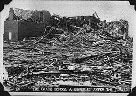
30 minutes later after producing the Blackwell tornado, the same supercell produced another violent and long-tracked tornado just east of the first tornado track near the Kansas/Oklahoma border. It proceeded northward across Sumner and Cowley Counties. The town of Udall was especially hard hit with F5 damage that included the disintegration of numerous structures and homes all across the town. Even the town's water tower was toppled. The funnel, about 1,300 yd (0.74 mi) wide, hit Udall at around 10:30 PM CDT. Half of the town's population was killed or injured. Numerous homes and businesses were destroyed, many of which were swept away. Vehicles were thrown hundreds of yards and mangled beyond recognition, including a pickup truck that was wrapped around a tree and stripped of everything but its frame and tires.[2] The Udall public school building sustained major damage, with beams snapped and blown away.[3][4][5] The tornado later dissipated after traveling over 50 mi (80 km) from the Oklahoma border to southeast of Wichita. This tornado was the deadliest in the state's history with 80 fatalities and over 200 injured.
Other tornadoes
| State | Total | County | County total |
|---|---|---|---|
| Kansas | 80 | Cowley | 75 |
| Sumner | 5 | ||
| Oklahoma | 22 | Kay | 20 |
| Roger Mills | 2 | ||
| Totals | 102 | ||
| All deaths were tornado-related | |||
In addition to the F5 tornadoes, NWS officials confirmed an additional F2 tornado near Tonkawa which may have been either part of the Blackwell tornado or a satellite tornado. Other tornadoes in the region occurred on May 27 near the same region but did little damage. Among them were those produced by a thunderstorm which traveled through the Oklahoma City, Oklahoma area, where it produced weak tornadoes with minimal damage in the towns of Norman and Chickasha.
Another deadly tornado occurred south of Woodward and at Cheyenne in Roger Mills County in southwestern Oklahoma, killing two people. This storm originated from the Texas Panhandle. The final tornado in the hardest-hit region occurred during the early morning hours of May 26 when a weak tornado occurred in Salisaw in Sequoyah County near the Arkansas border.
Numerous tornadoes occurred across the Midwestern states from Arkansas to Illinois. The strongest tornado was located near the Little Rock area but no fatalities were reported with this tornado or any other on May 26.
See also
References
- Storm Electricity Aspects of the Blackwell/Udall Storm of 25 May 1955 - Don Burgess, University of Oklahoma (CIMMS)
- Grazulis, Thomas P (July 1993). Significant Tornadoes 1680-1991. St. Johnsbury, VT: The Tornado Project of Environmental Films. ISBN 1-879362-03-1.
- "The Indefinitive List of the Strongest Tornadoes Ever Recorded (Pre-1970): Part II |". Archived from the original on 2013-06-30. Retrieved 2013-06-23.
- http://www.crh.noaa.gov/ict/udall/udall.php
- "Archived copy". Archived from the original on 2013-11-19. Retrieved 2013-10-09.CS1 maint: archived copy as title (link)
Bibliography
- Thomas P. Grazulis (1993). Significant Tornadoes 1680–1991, A Chronology and Analysis of Events. The Tornado Project of Environmental Films. ISBN 1-879362-00-7 (hardcover).