Fengtai District
| Fengtai 丰台区 | |
|---|---|
| District | |
 | |
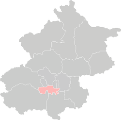 Location of Fengtai District in Beijing | |
| Country | People's Republic of China |
| Municipality | Beijing |
| Township-level divisions |
14 subdistricts 2 town 5 townships |
| Area | |
| • Total | 306 km2 (118 sq mi) |
| Population (2010) | |
| • Total | 2,112,000 |
| • Density | 6,900/km2 (18,000/sq mi) |
| Time zone | UTC+8 (China Standard) |
| Postal code | 100071 |
| Area code(s) | 0010 |
| Website | www.bjft.gov.cn |
Fengtai District (simplified Chinese: 丰台区; traditional Chinese: 豐台區; pinyin: Fēngtái Qū) is a district of the municipality of Beijing. It lies to the southwest of the city center, extending into the city's southwestern suburbs.
History
The Western Han dynasty Prince Liu Jian and his wife were buried in Dabaotai village in southwestern Fengtai over 2,000 years ago. The tombs were discovered in 1974 and are now open to visitors at the Dabaotai Western Han Dynasty Mausoleum on Fengbo Road.
In Qing Dynasty times, Fengtai was where the Imperial Manchu Army had its camps, trained, and held parades on festive occasions.
It is 304.2 square kilometres (117.5 sq mi) in area, making it the third-largest precinct in the greater urban part of Beijing, and is home to 790,000 inhabitants.
It is divided into 14 subdistricts of the city proper of Beijing, 2 towns, and 5 townships (2 of which are suburbs of the city proper of Beijing). This precinct is newly urbanized in comparison to those precincts in the old city, and until the mid-1980s, it was still a mostly rural area where pig pens and goat pens were common, and major parts of the precinct had no electricity. It was only during the recent rapid economic development that the precinct was urbanized. Its postal code is 100071.
Changxindian (population 78,092) and Yungang (population 32,894) Subdistricts of Beijing make up an urban area distinct from Beijing.
Administrative divisions
The district administers 14 subdistricts, 2 towns, and 5 townships of which carry the "area" (地区) label:[1][2]
| Name | Chinese (S) | Hanyu Pinyin | Population (2010)[3] | Area (km2) |
|---|---|---|---|---|
| Fengtai Subdistrict | 丰台街道 | Fēngtái Jiēdào | 144,185 | 8.90 |
| You'anmen Subdistrict | 右安门街道 | Yòu'ānmén Jiēdào | 83,936 | 4.32 |
| Taipingqiao Subdistrict | 太平桥街道 | Tàipíngqiáo Jiēdào | 63,588 | 9.81 |
| Xiluoyuan Subdistrict | 西罗园街道 | Xīluōyuán Jiēdào | 83,430 | 3.02 |
| Dahongmen Subdistrict | 大红门街道 | Dàhóngmén Jiēdào | 193,382 | 13.50 |
| Nanyuan Subdistrict | 南苑街道 | Nányuàn Jiēdào | 48,076 | 28.00 |
| Donggaodi Subdistrict | 东高地街道 | Dōnggāodì Jiēdào | 44,912 | 4.00 |
| Dongtiejiangying Subdistrict | 东铁匠营街道 | Dōngtiějiàngyíng Jiēdào | 144,894 | 13.20 |
| Lugouqiao Subdistrict | 卢沟桥街道 | Lúgōuqiáo Jiēdào | 181,666 | 59.73 |
| Xincun Subdistrict | 新村街道 | Xīncūn Jiēdào | 159,357 | 8.68 |
| Changxindian Subdistrict | 长辛店街道 | Zhǎngxīndiàn Jiēdào | 80,639 | 46.63 |
| Yungang Subdistrict | 云岗街道 | Yúngǎng Jiēdào | 32,711 | 8.53 |
| Majiabao Subdistrict | 马家堡街道 | Mǎjiābǎo Jiēdào | 119,595 | 4.90 |
| Heyi Subdistrict | 和义街道 | Héyì Jiēdào | 40,477 | 6.80 |
| Fangzhuang (Subdistrict) Area | 方庄(街道)地区 | Fāngzhuāng (Jiēdào) Dìqū | 83,454 | 5.53 |
| Wuanpingcheng (Subdistrict) Area | 宛平城(街道)地区 | Wǎnpíngchéng (Jiēdào) Dìqū | 49,180 | 22.10 |
| Lugouqiao (Township) Area | 卢沟桥(乡)地区 | Lúgōuqiáo (Xiāng) Dìqū | 173,690 | 56.30 |
| Huaxiang (Township) Area | 花乡(乡)地区 | Huāxiāng (Xiāng) Dìqū | 143,041 | 50.15 |
| Nanyuan (Township) Area | 南苑(乡)地区 | Nányuàn (Xiāng) Dìqū | 140,155 | 56.74 |
| Changxindian town | 长辛店镇 | Zhǎngxīndiàn Zhèn | 47,986 | 58.60 |
| Wangzuo town | 王佐镇 | Wángzuǒ Zhèn | 53,808 | 61.33 |
Communities
Transportation
The southwestern stretches of the 2nd, 3rd, 4th, 5th and 6th Ring Roads all run through the area, as well as the Jingshi Expressway (Jingzhu Expressway).
Beijing Nanyuan Airport is located in the district.
Beijing West Railway Station and Beijing South Railway Station, the only stations in Beijing with high-speed rail service, are both located in the northeastern part of Fengtai, near its border with Xicheng. Fengtai Railway Station is currently under renovation.
Metro
Fengtai is currently served by nine metro lines of the Beijing Subway:


Tourism
- Beijing World Park
- White Cloud Temple
- Marco Polo Bridge
- Wanping Fortress, at the eastern end of the bridge
- Museum of the War of Chinese People's Resistance Against Japanese Aggression, inside the fortress
Economy
China United Airlines has its headquarters in Fengtai District.[4] Okay Airways previously had its headquarters in Fengtai District.[5][6]
References
Notes
- ↑ These townships are officially classified as subdistricts, but as they coincide with the area of the same name, they are commonly named "areas" (地区)
- ↑ 2011年统计用区划代码和城乡划分代码:丰台区 (in Chinese). National Bureau of Statistics of the People's Republic of China. Archived from the original on 2013-01-02. Retrieved 2013-08-07.
- ↑ shi, Guo wu yuan ren kou pu cha ban gong; council, Guo jia tong ji ju ren kou he jiu ye tong ji si bian = Tabulation on the 2010 population census of the people's republic of China by township / compiled by Population census office under the state; population, Department of; statistics, employment statistics national bureau of (2012). Zhongguo 2010 nian ren kou pu cha fen xiang, zhen, jie dao zi liao (Di 1 ban. ed.). Beijing Shi: Zhongguo tong ji chu ban she. ISBN 978-7-5037-6660-2.
- ↑ "联系我们." China United Airlines. Retrieved on October 12, 2012. "北京市丰台区警备东路6号西区一号院"
- ↑ "北京总公司." Okay Airways. Retrieved on October 4, 2009. "北京总公司" and "北京市丰台区方庄芳星园三区18号"
- ↑ "China to approve private airline - report.(Okay Airways Co)(Brief Article)." Airline Industry Information. February 22, 2005. Retrieved on October 4, 2009.
General references
- Harper, Damian, Beijing: City Guide, 7th Edition, Oakland, California: Lonely Planet Publications, 2007. Cf. pp. 96–98, 138, 266-267.
- Harper, Damian, Beijing: City Guide, 6th Edition, Oakland, California : Lonely Planet Publications, 2005. ISBN 1-74059-782-6. Cf. section beginning on p. 88, "Fengtai & Xuanwu".
External links
| Wikivoyage has a travel guide for Fengtai. |

- Fengtai District, Beijing Municipality (in Chinese)
| Administration |
|  | ||||||
|---|---|---|---|---|---|---|---|---|
| Education | ||||||||
| Transportation |
| |||||||
| Visitor attractions |
| |||||||
| Municipal agencies |
| |||||||
| ||||||||
Coordinates: 39°49′42″N 116°16′56″E / 39.828273°N 116.282161°E