Worthington, Massachusetts
| Worthington, Massachusetts | ||
|---|---|---|
| Town | ||
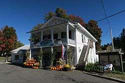 Corners Grocery | ||
| ||
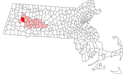 Location in Hampshire County in Massachusetts | ||
| Coordinates: 42°23′50″N 72°56′10″W / 42.39722°N 72.93611°WCoordinates: 42°23′50″N 72°56′10″W / 42.39722°N 72.93611°W | ||
| Country | United States | |
| State | Massachusetts | |
| County | Hampshire | |
| Settled | 1764 | |
| Incorporated | 1768 | |
| Government | ||
| • Type | Open town meeting | |
| Area | ||
| • Total | 32.1 sq mi (83.1 km2) | |
| • Land | 31.9 sq mi (82.7 km2) | |
| • Water | 0.2 sq mi (0.4 km2) | |
| Elevation | 1,433 ft (437 m) | |
| Population (2010) | ||
| • Total | 1,156 | |
| • Density | 36/sq mi (14.0/km2) | |
| Time zone | UTC-5 (Eastern) | |
| • Summer (DST) | UTC-4 (Eastern) | |
| ZIP Code | 01098 | |
| Area code(s) | 413 | |
| FIPS code | 25-82175 | |
| GNIS feature ID | 0618212 | |
| Website |
www | |
Worthington is a town in Hampshire County, Massachusetts, United States. The population was 1,156 at the 2010 census,[1] down from 1,270 at the 2000 census. It is part of the Springfield, Massachusetts Metropolitan Statistical Area.
History
Worthington was first settled in 1764 and was officially incorporated in 1768. The town's officials had settled for new land after the settling of Northampton in 1654. The town's oldest buildings are believed to be around the west side near the neighboring town of Middlefield and built somewhere near the late 1740s to 1750s.
Geography
Worthington is in western Hampshire County, in the Berkshires. It is bordered by Cummington to the north, Chesterfield to the east, Huntington to the southeast, Chester in Hampden County to the south, Middlefield to the southwest, and Peru in Berkshire County to the west. Worthington Center and Worthington Corners are two neighboring villages near the center of the town, while Ringville and South Worthington are in the southeast and West Worthington is in the northwest.
Massachusetts Route 112 crosses the town, leading north to Cummington and south to Huntington. Massachusetts Route 143 follows Route 112 briefly northeast from Worthington Corners but leads east to Chesterfield and Williamsburg, and west to Peru and Hinsdale.
According to the United States Census Bureau, Worthington has a total area of 32.1 square miles (83.1 km2), of which 31.9 square miles (82.7 km2) are land and 0.2 square miles (0.4 km2), or 0.46%, are water.[1] The town is within the Westfield River watershed, with the Middle Branch of the Westfield flowing through the western side of the town.
Demographics
| Historical population | ||
|---|---|---|
| Year | Pop. | ±% |
| 1850 | 1,134 | — |
| 1860 | 1,041 | −8.2% |
| 1870 | 860 | −17.4% |
| 1880 | 758 | −11.9% |
| 1890 | 714 | −5.8% |
| 1900 | 675 | −5.5% |
| 1910 | 569 | −15.7% |
| 1920 | 409 | −28.1% |
| 1930 | 486 | +18.8% |
| 1940 | 471 | −3.1% |
| 1950 | 462 | −1.9% |
| 1960 | 597 | +29.2% |
| 1970 | 712 | +19.3% |
| 1980 | 932 | +30.9% |
| 1990 | 1,156 | +24.0% |
| 2000 | 1,270 | +9.9% |
| 2010 | 1,156 | −9.0% |
| * = population estimate. Source: United States Census records and Population Estimates Program data.[2][3][4][5][6][7][8][9][10][11] | ||
At the 2000 census,[12] there were 1,270 people, 503 households and 363 families residing in the town. The population density was 39.6 per square mile (15.3/km²). There were 582 housing units at an average density of 18.2 per square mile (7.0/km²). The racial makeup of the town was 98.27% White, 0.31% African American, 0.08% Native American, 0.24% Asian, and 1.10% from two or more races. Hispanic or Latino of any race were 1.02% of the population.
There were 503 households of which 31.8% had children under the age of 18 living with them, 60.8% were married couples living together, 7.6% had a female householder with no husband present, and 27.8% were non-families. 21.3% of all households were made up of individuals and 8.0% had someone living alone who was 65 years of age or older. The average household size was 2.52 and the average family size was 2.96.
24.5% of the population were under the age of 18, 6.3% from 18 to 24, 26.8% from 25 to 44, 31.4% from 45 to 64, and 11.0% who were 65 years of age or older. The median age was 42 years. For every 100 females, there were 98.1 males. For every 100 females age 18 and over, there were 92.6 males.
The median household income was $53,047 and the median family income was $60,132. Males had a median income of $42,500 compared with $26,438 for females. The per capita income for the town was $24,190. About 1.5% of families and 3.5% of the population were below the poverty line, including 2.0% of those under age 18 and 1.4% of those age 65 or over.
In popular culture
Worthington is discussed by name in the Aaron Lewis song "Massachusetts" and referenced by the population size in "Country Boy". Both songs are on the album Town Line, released in 2011.
Notable people
- Russell Conwell (1843-1925), founder of Temple University
- Aaron Lewis, lead singer of Staind and current country music singer
- Alfred P. Stone (1813-1865), US congressman from Ohio
- Moses Sash, African American soldier during the American Revolution and Shays' Rebellion
See also
References
- 1 2 "Geographic Identifiers: 2010 Census Summary File 1 (G001): Worthington town, Hampshire County, Massachusetts". American Factfinder. U.S. Census Bureau. Retrieved August 9, 2017.
- ↑ "Total Population (P1), 2010 Census Summary File 1". American FactFinder, All County Subdivisions within Massachusetts. United States Census Bureau. 2010.
- ↑ "Massachusetts by Place and County Subdivision - GCT-T1. Population Estimates". United States Census Bureau. Retrieved July 12, 2011.
- ↑ "1990 Census of Population, General Population Characteristics: Massachusetts" (PDF). US Census Bureau. December 1990. Table 76: General Characteristics of Persons, Households, and Families: 1990. 1990 CP-1-23. Retrieved July 12, 2011.
- ↑ "1980 Census of the Population, Number of Inhabitants: Massachusetts" (PDF). US Census Bureau. December 1981. Table 4. Populations of County Subdivisions: 1960 to 1980. PC80-1-A23. Retrieved July 12, 2011.
- ↑ "1950 Census of Population" (PDF). Bureau of the Census. 1952. Section 6, Pages 21-10 and 21-11, Massachusetts Table 6. Population of Counties by Minor Civil Divisions: 1930 to 1950. Retrieved July 12, 2011.
- ↑ "1920 Census of Population" (PDF). Bureau of the Census. Number of Inhabitants, by Counties and Minor Civil Divisions. Pages 21-5 through 21-7. Massachusetts Table 2. Population of Counties by Minor Civil Divisions: 1920, 1910, and 1920. Retrieved July 12, 2011.
- ↑ "1890 Census of the Population" (PDF). Department of the Interior, Census Office. Pages 179 through 182. Massachusetts Table 5. Population of States and Territories by Minor Civil Divisions: 1880 and 1890. Retrieved July 12, 2011.
- ↑ "1870 Census of the Population" (PDF). Department of the Interior, Census Office. 1872. Pages 217 through 220. Table IX. Population of Minor Civil Divisions, &c. Massachusetts. Retrieved July 12, 2011.
- ↑ "1860 Census" (PDF). Department of the Interior, Census Office. 1864. Pages 220 through 226. State of Massachusetts Table No. 3. Populations of Cities, Towns, &c. Retrieved July 12, 2011.
- ↑ "1850 Census" (PDF). Department of the Interior, Census Office. 1854. Pages 338 through 393. Populations of Cities, Towns, &c. Retrieved July 12, 2011.
- ↑ "American FactFinder". United States Census Bureau. Retrieved 2008-01-31.
External links
| Wikimedia Commons has media related to Worthington, Massachusetts. |
- Town of Worthington official website
- Worthington Historical Society
- MHC Survey Reconnaissance Town Report: Worthington Massachusetts Historical Commission, 1982.
Municipalities and communities of Hampshire County, Massachusetts, United States | ||
|---|---|---|
| Cities |  | |
| Towns | ||
| CDPs | ||
| Other villages | ||
| Footnotes | ‡This populated place also has portions in an adjacent county or counties | |