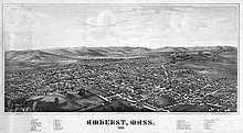
Amherst, Massachusetts
| Amherst, Massachusetts | |||
|---|---|---|---|
| Town | |||
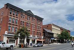 Amherst Center. Shops along the west side of South Pleasant Street, February 2005. | |||
| |||
| Nickname(s): The People's Republic of Amherst[1][2][3] | |||
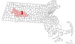 Location in Hampshire County in Massachusetts | |||
| Coordinates: 42°23′N 72°31′W / 42.383°N 72.517°W | |||
| Country | United States | ||
| State | Massachusetts | ||
| County | Hampshire | ||
| Settled | 1703 | ||
| Incorporated | February 13, 1759 | ||
| Government | |||
| • Type | Representative town meeting | ||
| Area | |||
| • Total | 27.7 sq mi (71.8 km2) | ||
| • Land | 27.6 sq mi (71.5 km2) | ||
| • Water | 0.1 sq mi (0.3 km2) | ||
| Elevation | 295 ft (90 m) | ||
| Population (2010) | |||
| • Total | 37,819 | ||
| • Density | 1,370/sq mi (529.0/km2) | ||
| Time zone | UTC−5 (Eastern) | ||
| • Summer (DST) | UTC−4 (Eastern) | ||
| ZIP Codes | 01002, 01003 (UMass), 01004 (post office boxes), 01059 (North Amherst post office) | ||
| Area code(s) | 413 | ||
| FIPS code | 25-01325 | ||
| GNIS feature ID | 0618195 | ||
| Website |
www | ||

Amherst (/ˈæmərst/ (![]()
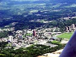
Amherst has three census-designated places; Amherst Center, North Amherst, and South Amherst.
Amherst is part of the Springfield, Massachusetts Metropolitan Statistical Area. Lying 22 miles (35 km) north of the city of Springfield, Amherst is considered the northernmost town in the Hartford-Springfield Metropolitan Region, "The Knowledge Corridor".
History
The earliest known document of the lands now comprising Amherst is the deed of purchase dated December 1658 between John Pynchon of Springfield and three native inhabitants, referred to as Umpanchla, Quonquont, and Chickwalopp.[8] According to the deed, "ye Indians of Nolwotogg (Norwottuck) upon ye River of Quinecticott (Connecticut)" sold the entire area in exchange for "two Hundred fatham of Wampam & Twenty fatham, and one large Coate at Eight fatham wch Chickwollop set of, of trusts, besides severall small giftes" [sic]. Amherst celebrated its 250th anniversary in 2009. The Amherst 250th Anniversary Celebration Committee and Amherst Historical Society organized events, including a book published by the Historical Society and written by Elizabeth M. Sharpe, Amherst A to Z.
Amherst was first visited by Europeans as early as 1665 when Nathaniel Dickinson (the great great grandfather of poet Emily Dickinson) surveyed the lands for its mothertown Hadley. The first permanent English settlements arrived in 1727, and it was part of Hadley, even when it gained precinct status in 1734. It eventually gained township in 1759.
When it incorporated, the colonial governor assigned the town the name "Amherst" after Jeffery Amherst, 1st Baron Amherst. Many colonial governors at the time scattered his name amidst the influx of new town applications, which is why several towns in the Northeast bear the name. Amherst was a hero of the French and Indian War who, according to popular legend, singlehandedly won Canada for the British and banished France from North America. Popular belief has it that he supported the American side in the Revolutionary War and resigned his commission rather than fight for the British. Baron Amherst actually remained in the service of the Crown during the war—albeit in Great Britain rather than North America—where he organized the defense against the proposed Franco-Spanish Armada of 1779. Nonetheless, his previous service in the French and Indian War meant he remained popular in New England. Amherst is also infamous for recommending, in a letter to a subordinate, the use of smallpox-covered blankets in warfare against the Native Americans along with any "other method that can serve to Extirpate this Execrable Race".[9] For this reason, there have been occasional ad hoc movements to rename the town.[10] Suggested new names have included "Emily", after Emily Dickinson.
Geography and climate
According to the United States Census Bureau, Amherst has a total area of 27.7 square miles (71.8 km2), of which 27.6 square miles (71.5 km2) are land and 0.12 square miles (0.3 km2), or 0.48%, are water.[5] The town is bordered by Hadley to the west, Sunderland and Leverett to the north, Shutesbury, Pelham, and Belchertown to the east, and Granby and South Hadley to the south. The highest point in the town is on the northern shoulder of Mount Norwottuck at the southern border of the town; the peak is in Granby but the town's high point is a few yards away and is about 1,100 feet (340 m). The town is nearly equidistant from both the northern and southern state lines.
Amherst's ZIP Code of 01002 is the second-lowest number in the continental United States after Agawam (not counting codes used for specific government buildings such as the IRS).
Amherst has a humid continental climate that under the Köppen system marginally falls into the warm-summer category (dfb). It is interchangeable with the hot-summer subtype dfa with July means hovering around 71.4 °F (21.9 °C). Winters are cold and snowy, albeit daytime temperatures often remain above freezing. Under the 2012 USDA Plant Hardiness Zone system, Amherst (zip 01002) is in zone 5b;[11] however, Amherst closely borders zone 6a, which penetrates into Massachusetts in the Connecticut River Valley, and climate change may be shifting those zones.[12]
| Climate data for Amherst, Massachusetts (1981–2010 normals) | |||||||||||||
|---|---|---|---|---|---|---|---|---|---|---|---|---|---|
| Month | Jan | Feb | Mar | Apr | May | Jun | Jul | Aug | Sep | Oct | Nov | Dec | Year |
| Record high °F (°C) | 70 (21) |
70 (21) |
85 (29) |
93 (34) |
98 (37) |
101 (38) |
104 (40) |
100 (38) |
99 (37) |
90 (32) |
82 (28) |
72 (22) |
104 (40) |
| Average high °F (°C) | 34.6 (1.4) |
38.3 (3.5) |
46.5 (8.1) |
59.4 (15.2) |
70.2 (21.2) |
78.7 (25.9) |
83.4 (28.6) |
81.9 (27.7) |
74.5 (23.6) |
62.3 (16.8) |
50.8 (10.4) |
39.2 (4) |
60 (15.5) |
| Average low °F (°C) | 13.2 (−10.4) |
16.2 (−8.8) |
24.4 (−4.2) |
34.6 (1.4) |
44.8 (7.1) |
54.7 (12.6) |
59.3 (15.2) |
57.6 (14.2) |
49.2 (9.6) |
37.4 (3) |
29.7 (−1.3) |
20.0 (−6.7) |
36.8 (2.6) |
| Record low °F (°C) | −30 (−34) |
−27 (−33) |
−17 (−27) |
8 (−13) |
24 (−4) |
29 (−2) |
39 (4) |
32 (0) |
25 (−4) |
12 (−11) |
−4 (−20) |
−22 (−30) |
−30 (−34) |
| Average precipitation inches (mm) | 3.31 (84.1) |
3.12 (79.2) |
3.55 (90.2) |
3.87 (98.3) |
4.10 (104.1) |
4.12 (104.6) |
4.06 (103.1) |
3.71 (94.2) |
4.19 (106.4) |
4.75 (120.7) |
3.85 (97.8) |
3.48 (88.4) |
46.11 (1,171.2) |
| Average snowfall inches (cm) | 12.7 (32.3) |
9.4 (23.9) |
6.9 (17.5) |
1.3 (3.3) |
0 (0) |
0 (0) |
0 (0) |
0 (0) |
0 (0) |
0 (0) |
2.0 (5.1) |
8.7 (22.1) |
41.0 (104.1) |
| Average precipitation days (≥ 0.01 in) | 10.2 | 8.6 | 10.1 | 10.9 | 12.5 | 11.5 | 10.4 | 10.0 | 9.0 | 9.8 | 10.2 | 10.1 | 123.3 |
| Average snowy days (≥ 0.1 in) | 5.5 | 4.0 | 2.7 | .4 | 0 | 0 | 0 | 0 | 0 | .1 | 1.0 | 3.4 | 17.1 |
| Source: NOAA[13] | |||||||||||||
Demographics
| Historical population | ||
|---|---|---|
| Year | Pop. | ±% |
| 1790 | 1,233 | — |
| 1800 | 1,258 | +2.0% |
| 1810 | 1,469 | +16.8% |
| 1820 | 1,917 | +30.5% |
| 1830 | 2,631 | +37.2% |
| 1840 | 2,550 | −3.1% |
| 1850 | 3,057 | +19.9% |
| 1860 | 3,206 | +4.9% |
| 1870 | 4,035 | +25.9% |
| 1880 | 4,298 | +6.5% |
| 1890 | 4,512 | +5.0% |
| 1900 | 5,028 | +11.4% |
| 1910 | 5,112 | +1.7% |
| 1920 | 5,550 | +8.6% |
| 1930 | 5,883 | +6.0% |
| 1940 | 6,410 | +9.0% |
| 1950 | 10,856 | +69.4% |
| 1960 | 13,718 | +26.4% |
| 1970 | 26,331 | +91.9% |
| 1980 | 33,229 | +26.2% |
| 1990 | 35,228 | +6.0% |
| 2000 | 34,874 | −1.0% |
| 2010 | 37,819 | +8.4% |
| 2016* | 40,079 | +6.0% |
| * = population estimate[14] Source: United States Census records and Population Estimates Program data.[15][16][17][18][19][20][21][22][23][24][25] | ||
As of the 2010 U.S. Census, there were 37,819 people, 9,259 households, and 4,484 families residing in the town. There were 9,711 housing units. The racial makeup of the town was 76.9% White, 5.4% Black or African American, 0.2% Native American, 10.9% Asian, 0.03% Pacific Islander, 2.4% some other race, and 4.1% from two or more races. 7.3% of the population were Hispanic or Latino of any race.[26]
Of the 9,259 households in the town, 23.4% had children under the age of 18 living with them, 35.6% were headed by married couples living together, 16.3% had a female householder with no husband present, and 51.6% were non-families. Of all households, 27.3% were made up of individuals, and 9.7% were someone living alone who was 65 years of age or older. The average household size was 2.44 and the average family size was 2.88.[26]
In the town, 10.0% of the population were under the age of 18, 55.7% were from 18 to 24, 13.3% were from 25 to 44, 13.6% were from 45 to 64, and 7.4% were 65 years of age or older. The median age was 21.6 years. For every 100 females, there were 95.8 males. For every 100 females age 18 and over, there were 94.7 males.[26]
For the period 2011-15, the estimated median annual income for a household in the town was $48,059, and the median income for a family was $96,005. Male full-time workers had a median income of $64,750 versus $39,278 for females. The per capita income for the town was $18,905. About 8.7% of families and 34.7% of the population were below the poverty line, including 18.2% of those under age 18 and 4.5% of those age 65 or over.[27]
The reason for the large population living below the poverty line is the large number of students that live in Amherst. According to the 2010 5-year American Community Survey estimates, occupied housing units had a median household income of $50,063, which includes both renter and owner-occupied units. More specifically, owner-occupied units had a median income of $100,208, while renter-occupied housing units had a median income of $23,925. Large disparities in income between the two groups could explain the high poverty rate and lower median income, as students are the primary tenants of renter-occupied units within Amherst.
Of residents 25 years old or older, 41.7% have a graduate or professional degree, and only 4.9% did not graduate from high school. The largest industry is education, health, and social services, in which 51.9% of employed persons work.
These statistics given above include some but not all of the large student population, roughly 30,000 in 2010, many of whom only reside in the town part of the year. Amherst is home to thousands of part-time and full-time residents associated with the University of Massachusetts Amherst, Amherst College, and Hampshire College and many of those students are involved with the liberal politics of the town.
Income
Data is from the 2009–2013 American Community Survey 5-Year Estimates.[28][29][30]
| Rank | ZIP Code (ZCTA) | Per capita income |
Median household income |
Median family income |
Population | Number of households |
|---|---|---|---|---|---|---|
| Massachusetts | $35,763 | $66,866 | $84,900 | 6,605,058 | 2,530,147 | |
| Hampshire County | $29,460 | $61,227 | $81,385 | 159,267 | 58,828 | |
| United States | $28,155 | $53,046 | $64,719 | 311,536,594 | 115,610,216 | |
| 1 | 01002 | $27,691 | $54,422 | $96,929 | 29,266 | 9,248 |
| Amherst | $19,796 | $53,191 | $96,733 | 38,651 | 8,583 | |
| 2 | 01003 (UMass Amherst Campus) | $3,531 | $N/A | $N/A | 11,032 | 16 |
Government
Amherst has a representative town meeting for the legislative branch and a select board for the executive. The Select Board hires a town manager for daily administrative issues.[31]
Amherst's town meeting is a representative town meeting structure. In Amherst's town meeting, the town is divided into ten precincts, each with 24 members, elected for three-year terms.[31] With an additional 14 ex officio members, who are permitted to vote, (the 5 Select Board members; the 5 School Committee members; President of the Library Trustees; Chair of the Finance Committee; Town Manager; and a Moderator), the total membership of Town Meeting is 254.[31]
The Town converted from an open town meeting to a representative town meeting form in 1938.[32] In 1953, Amherst voters passed the "Town Manager Act", which established the office of a town manager and reduced a number of elected positions.[32] In 1995, a charter commission was approved to study Amherst's government; the charter majority recommended a 7-person Council and a mayor, while also maintaining a reduced size representative Town Meeting (150).[33] This proposal failed in two successive votes.[32]
In 2001, the League of Women Voters Amherst made a number of recommendations that were adopted in 2001 in the form of a revised "Amherst Town Government Act".[34] An effort shortly thereafter to amend the charter to eliminate the town meeting, and establish an elected mayor and a nine-member Town Council,[35] was rejected by voters twice, first in spring 2003 by fourteen votes and again on March 29, 2005 by 252 votes.
In 2016, a "charter commission" was approved to study Amherst's government. A majority of commissioners proposed a charter that would establish a 13-member Council with no mayor.[36][37] This proposal was voted on the March 27, 2018 local ballot,[38] and was passed by over 1,000 votes, a 58% majority[39].
State and federal representation
In the Massachusetts General Court, Amherst is in the "Hampshire, Franklin and Worcester" Senatorial District,[40] previously represented by Democratic State Senator Stanley Rosenberg until his resignation in 2018.[41] Representative Solomon Goldstein-Rose, elected September 8, 2016, as a Democrat, currently represents Amherst for the 3rd Hampshire District in the Massachusetts House of Representatives.[42] Goldstein-Rose withdrew from the Democratic Party in February, 2018 to become an independent representative.[43]
Amherst is represented at the federal level by an all-Democratic delegation, including Senators Elizabeth Warren and Ed Markey, and by Representative Jim McGovern of the Second Congressional District of Massachusetts.
Voter registration
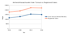
Voter registration data is from the state election enrollment statistics.
| Registered Voters and Party Enrollment [45] | |||||||
|---|---|---|---|---|---|---|---|
| Year | Democratic | Republican | Unenrolled | Total | |||
| 2004 | 8,522 | 47.8% | 1,231 | 6.9% | 7,623 | 42.8% | 17,816 |
| 2006 | 8,350 | 49.2% | 1,076 | 6.3% | 7,228 | 42.6% | 16,980 |
| 2008 | 9,343 | 49.3% | 1,076 | 5.7% | 8,257 | 43.6% | 18,956 |
| 2010 | 8,675 | 49.6% | 948 | 5.4% | 7,661 | 43.8% | 17,501 |
| 2012 | 10,324 | 46% | 1,219 | 5.4% | 10,665 | 47.6% | 22,425 |
| 2014 | 9,645 | 45% | 1,156 | 5.4% | 10,454 | 48.8% | 21,431 |
| 2016 | 10,414 | 46.9% | 1,146 | 5.2% | 10,202 | 46% | 22,196 |
Transportation
The Pioneer Valley Transit Authority, funded by local governments and the Five College Consortium, provides public transportation in the area, operated by University of Massachusetts Transportation Services. Service runs well into the early morning hours on weekends when school is in session. Students attending any colleges in the Five Colleges Consortium have a fee included in their tuition bills (service fee for UMass Amherst students and student activity fees for the other colleges) for each semester that prepays their bus fares for the semester. UMass Transit buses operate via a proof-of-payment system, in which there are random inspections of student identification cards and bus passes and transfers.
Peter Pan Bus Lines provides service between Amherst and Springfield, Boston, and other locations in New England.[46] Megabus provides service between New York City, Amherst, and Burlington, Vermont.[47]
Amtrak rail service is available in nearby Northampton on the Vermonter service between Washington D.C. and St. Albans, Vermont. More frequent Amtrak service to New York City and Washington, D.C., is available from Union Station in Springfield.
The closest major domestic and limited international air service is available through Bradley International Airport (BDL) in Windsor Locks, Connecticut. Bradley is located approximately one hour's driving time from Amherst. Major international service is available through Logan International Airport (BOS) in Boston, 90 miles away.
General aviation service is close by, at Northampton Airport, Westover Metropolitan Airport, and Turners Falls Airport.
Economy
Major employers in Amherst include University of Massachusetts Amherst, Amherst College, William D. Mullins Memorial Center, Hampshire College, and Amherst-Pelham Regional School District.[48]
Sports
- Games were played in town during the 1996 World Junior Ice Hockey Championships.
- The University of Massachusetts Amherst's Ultimate Frisbee Team, was ranked first the Division 1 Men's Ultimate league for the 2017 season.[49][50]
Education
The town is served by the Amherst-Pelham Regional School District, which also serves students from several other communities surrounding Amherst.
There are three tertiary institutions located in the town: the public University of Massachusetts Amherst (the flagship of the UMass system) and two private liberal arts colleges Amherst College and Hampshire College.
Sister cities
Notable residents
Historical
- Emily Dickinson (1830–1886) born and lived in Amherst, one of the most prominent and celebrated American poets.[54]
- Robert Frost (1874–1963) Pulitzer prize-winning poet who taught at Amherst College and retired there.
- Noah Webster (1758–1843) Author of An American Dictionary of the English Language
- Edward Hitchcock (1793–1864) educator, early geologist and a founder of the science of ichnology
- Osmyn Baker (1800–1875) born in Amherst, United States Congressman and lawyer[54]
- Mason Cook Darling (1801–1866) born in Amherst, United States Congressman from Wisconsin and first mayor of Fond du Lac, Wisconsin.[54]
- Edward Dickinson, (1803–1874), born in Amherst, lawyer, United States Congressman, and father of Emily Dickinson.[54]
- William S. Clark (1825–1886) Academician, politician, businessman; principal founder of the Massachusetts Agricultural College (now the University of Massachusetts Amherst), founder of the Sapporo Agricultural College (now the Hokkaido University).
- Helen Hunt Jackson (1830–1885) born in Amherst, noted author best known for A Century of Dishonor and her novel Ramona.[54]
- Eugene Field (1850–1895) raised in Amherst by cousin, Mary Field French; poet and humorist who wrote children's poem Wynken, Blynken, and Nod.
- Arthur Lithgow (1915–2004) lived and died in Amherst, noted actor, producer and director of Shakespeare plays, founder of the Great Lakes Shakespeare Festival in Ohio (today known as the Great Lakes Theatre Festival), former director of the McCarter Theatre in Princeton, NJ, father of actor John Lithgow.
- Harlan Fiske Stone (1872–1946), attended public schools in Amherst and Amherst College; dean of the Columbia Law School, 52nd Attorney General of the United States, and Chief Justice of the United States
- Howard Roger Garis (1873–1962), children's author who wrote the Uncle Wiggily book series
- Lilian Garis (1873–1954), author of juvenile fiction who under the pseudonym Laura Lee Hope wrote early volumes in the Bobbsey Twins series
- Robert Francis (1901–1987), poet
- Melvil Dewey (1851–1931), devised the Dewey Decimal System while an assistant librarian at Amherst College in 1876
- Chinua Achebe (1930–2013), was a professor at the University of Massachusetts from 1972 to 1976
- Paul Nitze (January 16, 1907 – October 19, 2004), born in Amherst, diplomat who helped shape defense policy over numerous presidential administrations.
- Ebenezer Mattoon (1755–1843), born in North Amherst, Lieutenant in Continental Army during American Revolution, US Congressman (1801–1803).[55]
Born or raised in Amherst
- Annie Baker, playwright
- Emily Dickinson, poet
- P. D. Eastman, children's author, illustrator, and screenwriter
- Michael Hixon, U.S. Olympic Athlete Rio 2016, men’s individual 3 meter springboard; 3 meter springboard synchro
- James D. Hornfischer, military historian and author
- James Ihedigbo, Detroit Lions defensive back
- Martin Johnson, of rock band Boys like Girls
- Amory Lovins, scientist and environmentalist
- J Mascis, singer, guitarist and songwriter for alternative rock band Dinosaur Jr.
- Eric Mabius, star of ABC show Ugly Betty, attended Amherst schools
- Julie McNiven, actress with recurring roles on Mad Men and Supernatural
- Ilan Mitchell-Smith, actor starring in 1985 film Weird Science, attended Amherst public schools
- Eli Noyes, animator, film producer, director
- Helen Palmer Geisel, children's author and first wife of Dr. Seuss
- Gil Penchina, Former CEO of Wikia, Inc., attended the University of Massachusetts Amherst
- Steve Porter, music producer
- Allen St. Pierre, executive director of NORML, attended public schools in Amherst and graduated from the University of Massachusetts Amherst
- Timothy Tau, writer and filmmaker
- Uma Thurman, Oscar-nominated actress, whose father, Robert Thurman, taught at Amherst College
- Martin M. Wattenberg, artist and computer scientist
- Zoe Weizenbaum, child actress
- Jamila Wideman (born 1975), female left-handed point guard basketball player, lawyer and activist
- Elisha Yaffe, comedian, actor, and producer
- Kevin Ziomek, American professional baseball pitcher in the Detroit Tigers organization
Live in Amherst
- Gavin Andresen, Bitcoin Foundation founder and Bitcoin Core contributor
- Christian Appy, author of Patriots and Working-Class War, professor at University of Massachusetts Amherst
- Christopher Benfey, author of The Great Wave, professor at Mount Holyoke College
- Holly Black, author of Tithe, Valiant, Ironside, and co-author of the Spiderwick Chronicles
- Augusten Burroughs, author of Running with Scissors
- Michelle Chamuel, singer, songwriter, producer
- Cassandra Clare, author of the famous The Mortal Instruments and The Infernal Devices
- Arda Collins, poet and winner of the Yale Series of Younger Poets Competition
- Tony DiTerlizzi, author of The Spider and the Fly and co-author/illustrator for Spiderwick Chronicles
- Peter Elbow, compositionist and professor emeritus at the University of Massachusetts Amherst
- Joseph Ellis, historian and author of Founding Brothers
- Martín Espada, poet, professor at the University of Massachusetts and author of the 2006 The Republic of Poetry, among others
- Black Francis, singer/guitarist of the alternative rock band the Pixies, attended UMass Amherst
- Rebecca Guay, artist specializing in watercolor painting and illustration
- Norton Juster, author of The Phantom Tollbooth
- John Katzenbach, author of The Madman's Tale
- Julius Lester, author and professor at the University of Massachusetts Amherst
- Michael Lesy, author of Wisconsin Death Trip, professor at Hampshire College
- J Mascis of alternative rock group Dinosaur Jr.
- Charles C. Mann (born 1955), journalist and author of 1491: New Revelations of the Americas Before Columbus and 1493: Uncovering the New World Columbus Created
- John Olver, politician who served in the US House of Representatives
- John Elder Robison, author of Look Me in the Eye, also older brother of Augusten Burroughs
- Joey Santiago, lead guitarist of the alternative rock band the Pixies, attended UMass Amherst
- Archie Shepp, jazz musician and professor emeritus at the University of Massachusetts Amherst
- Chris Smither, folk/blues singer, guitarist, and songwriter
- James Tate (born 1943), poet and professor at the University of Massachusetts Amherst
- Carl Vigeland, author of In Concert and many other books
- Dara Wier, poet and professor in the MFA Program for Poets & Writers at the University of Massachusetts Amherst
- Roman Yakub, composer
Points of interest
- Amherst Center Cultural District, formed in 2016, and Amherst Business Improvement District [56]
- Amherst Area Chamber of Commerce
- Amherst Cinema Arts Center: a local non-profit theater showing mostly arthouse and independent films[57]
- Beneski Museum of Natural History, including the Hitchcock Ichnological Cabinet
- Emily Dickinson Museum, birthplace and lifelong residence of poet Emily Dickinson, now a museum. She is buried nearby in West Cemetery on Triangle Street.
- Eric Carle Museum of Picture Book Art
- Hitchcock Center for the Environment, an environmental education center on the grounds of Hampshire College
- Mead Art Museum at Amherst College: 18,000 items with a particular strength in American art
- Theodore Baird Residence, designed by architect Frank Lloyd Wright
- W. E. B. Du Bois Library at the University of Massachusetts Amherst: the tallest academic library in the United States
- Yiddish Book Center
See also
References
- ↑ Hollander, Paul (1981). Political Pilgrims: Western Intellectuals in Search of the Good Society. Piscataway, New Jersey: Transaction Publishers. p. xxv. Retrieved 2013-04-07.
Brentlinger, a professor of philosophy at the University of Massachusetts at Amherst, was robustly and proudly alienated from American society and culture...he has probably benefited from living amidst like-minded people in what has been jestingly called 'the people's republic of Amherst, Mass.'
- ↑ Arkes, Hadley (1996), "Response to Fund", in Schaefer, David Lewis; Schaefer, Roberta Rubel, The future of cities, Lanham, Maryland: University Press of America, Inc, p. 9, retrieved 2013-04-07,
I come to you from one of those places that is in America, but not quite of it...In my case it is the People's Republic of Amherst
- ↑ Sarat, Austin (2008), "Contested Terrain: Visions of Multiculturalism in an American Town", in Minow, Martha; Shweder, Richard A.; Markus, Hazel, Just Schools: Pursuing Equality in Societies of Difference, New York: Russell Sage Foundation, p. 102, retrieved 2013-04-07,
I live in a place whose liberal tendencies have earned it various nicknames. For example, it has been called 'The People's Republic of Amherst'
- ↑ "Amherst". Dictionary.com. Retrieved 9 November 2014.
- 1 2 "Geographic Identifiers: 2010 Census Summary File 1 (G001): Amherst town, Hampshire County, Massachusetts". American Factfinder. U.S. Census Bureau. Retrieved August 7, 2017.
- ↑ "languagehat.com : AMHERST". www.languagehat.com.
- ↑ See, e.g., local T-shirt for sale; Chris Rohmann, "Stage Struck: Silent But Deadly", Valley Advocate, Oct. 20, 2011; and "Living in Western Massachusetts" Archived 2012-08-25 at the Wayback Machine., Pioneer Valley Cohousing (last visited Sept. 16, 2012).
- ↑ Carpenter, Edward Wilson; Charles Frederick Morehouse (1896). The History of the Town of Amherst, Massachusetts. Amherst, Mass.: Press of Carpenter & Morehouse. pp. 1–2. OCLC 11223569. Retrieved 20 July 2015.
- ↑ d'Errico, Peter. "Jeffrey Amherst and Smallpox Blankets". Peter d'Errico's Law Page. Retrieved 20 July 2015.
- ↑ MERZBACH, SCOTT. "Belchertown man wants Amherst's town name banished". Daily Hampshire Gazette. Retrieved 14 July 2018.
- ↑ USDA Plant Hardiness Zone Map
- ↑ Massachusetts Plant Hardiness Zone Map, USDA.
- ↑ "NowData – NOAA Online Weather Data". National Oceanic and Atmospheric Administration. Retrieved 2012-05-18.
- ↑ "Annual Estimates of the Resident Population: April 1, 2010 to July 1, 2016 (PEPANNRES): Massachusetts Minor Civil Divisions". American Factfinder. U.S. Census Bureau. Retrieved August 7, 2017.
- ↑ "Total Population (P1), 2010 Census Summary File 1". American FactFinder, All County Subdivisions within Massachusetts. United States Census Bureau. 2010.
- ↑ "Massachusetts by Place and County Subdivision - GCT-T1. Population Estimates". United States Census Bureau. Retrieved July 12, 2011.
- ↑ "1990 Census of Population, General Population Characteristics: Massachusetts" (PDF). US Census Bureau. December 1990. Table 76: General Characteristics of Persons, Households, and Families: 1990. 1990 CP-1-23. Retrieved July 12, 2011.
- ↑ "1980 Census of the Population, Number of Inhabitants: Massachusetts" (PDF). US Census Bureau. December 1981. Table 4. Populations of County Subdivisions: 1960 to 1980. PC80-1-A23. Retrieved July 12, 2011.
- ↑ "1950 Census of Population" (PDF). Bureau of the Census. 1952. Section 6, Pages 21-10 and 21-11, Massachusetts Table 6. Population of Counties by Minor Civil Divisions: 1930 to 1950. Retrieved July 12, 2011.
- ↑ "1920 Census of Population" (PDF). Bureau of the Census. Number of Inhabitants, by Counties and Minor Civil Divisions. Pages 21-5 through 21-7. Massachusetts Table 2. Population of Counties by Minor Civil Divisions: 1920, 1910, and 1920. Retrieved July 12, 2011.
- ↑ "1890 Census of the Population" (PDF). Department of the Interior, Census Office. Pages 179 through 182. Massachusetts Table 5. Population of States and Territories by Minor Civil Divisions: 1880 and 1890. Retrieved July 12, 2011.
- ↑ "1870 Census of the Population" (PDF). Department of the Interior, Census Office. 1872. Pages 217 through 220. Table IX. Population of Minor Civil Divisions, &c. Massachusetts. Retrieved July 12, 2011.
- ↑ "1860 Census" (PDF). Department of the Interior, Census Office. 1864. Pages 220 through 226. State of Massachusetts Table No. 3. Populations of Cities, Towns, &c. Retrieved July 12, 2011.
- ↑ "1850 Census" (PDF). Department of the Interior, Census Office. 1854. Pages 338 through 393. Populations of Cities, Towns, &c. Retrieved July 12, 2011.
- ↑ "amherstma.gov" (PDF). amherstma.gov.
- 1 2 3 "Profile of General Population and Housing Characteristics: 2010 Census Summary File 1 (DP-1): Amherst town, Hampshire County, Massachusetts". American Factfinder. U.S. Census Bureau. Retrieved August 7, 2017.
- ↑ "Selected Economic Characteristics: 2011-2015 American Community Survey 5-Year Estimates (DP03): Amherst town, Hampshire County, Massachusetts". American Factfinder. U.S. Census Bureau. Retrieved August 7, 2017.
- ↑ "SELECTED ECONOMIC CHARACTERISTICS 2009-2013 American Community Survey 5-Year Estimates". U.S. Census Bureau. Retrieved 2015-01-12.
- ↑ "ACS DEMOGRAPHIC AND HOUSING ESTIMATES 2009-2013 American Community Survey 5-Year Estimates". U.S. Census Bureau. Retrieved 2015-01-12.
- ↑ "HOUSEHOLDS AND FAMILIES 2009-2013 American Community Survey 5-Year Estimates". U.S. Census Bureau. Retrieved 2015-01-12.
- 1 2 3 "Town Meeting", Town of Amherst Official Website (last visited March 21, 2014).
- 1 2 3 Amherst League of Women Voters, "Your Amherst Government" (2009).
- ↑ 1996 Charter Commission Report.
- ↑ League of Women Voters of Amherst 75th Anniversary Program", p.11.
- ↑ "2002 Charter Commission Report" (PDF). votenooncharter.org.
- ↑ Amherst League of Women Voters, "League of Women Voters Offers Evaluative Criteria".
- ↑ Amherst Charter Commission, "Final Report and Home Rule Charter".
- ↑ Amherst, Massachusetts, town website, "Charter Commission" (last visited March 4, 2018).
- ↑ Daily Hampshire Gazette, (last visited August 18, 2018).
- ↑ "Massachusetts Senatorial Districts", Secretary of the Commonwealth of Massachusetts. (last visited March 21, 2014)
- ↑ "Stan Rosenberg to quit Senate after scathing ethics report". Retrieved July 9, 2018.
- ↑ "Solomon Goldstein-Rose wins the 3rd Hampshire District seat". masslive.com. Retrieved 2017-09-26.
- ↑ Merzbach, Scott (February 22, 2018). "State Rep. Solomon Goldstein-Rose leaves Democratic Party". Amherst Bulletin. Retrieved 21 March 2018.
- ↑ "Every election at your fingertips". Retrieved March 18, 2018.
- ↑ "Registration Statistics". Retrieved March 17, 2018.
- ↑ "Welcome". Peter Pan Bus Lines. Retrieved 2018-03-20.
- ↑ megabus.com. "Bus from Burlington to Boston and from Boston to Burlington | megabus". us.megabus.com. Retrieved 2018-03-20.
- ↑ Search Results – Amherst, Massachusetts- ReferenceUSA Current Businesses
- ↑ "College Rankings, Presented by NUTC | Ultiworld". Ultiworld. Retrieved 2017-09-25.
- ↑ "ZooDisc | UMass Ultimate Frisbee". blogs.umass.edu. Retrieved 2018-03-20.
- ↑ "Nyeri Sister City Committee". Archived from the original on 28 May 2010. Retrieved 2010-06-06.
- ↑ "La Paz Centro Sister City Committee". Archived from the original on 28 May 2010. Retrieved 2010-06-06.
- ↑ "Kanegasaki Sister City Committee". Archived from the original on 28 May 2010. Retrieved 2010-06-06.
- 1 2 3 4 5 Who Was Who in America, Historical Volume, 1607–1896. Marquis Who's Who. 1967.
- ↑ "Mary Mattoon and her hero of the revolution" by Alice M. Walker, Carpenter and Morehouse, 1902
- ↑ "Amherst Center Cultural District - Amherst Downtown Business Improvement District". Amherst Downtown Business Improvement District. Retrieved 2018-03-20.
- ↑ "About Us". Amherst Cinema. Retrieved July 1, 2015.
External links
| Wikimedia Commons has media related to Amherst, Massachusetts. |
| Wikivoyage has a travel guide for Amherst, Massachusetts. |
| Wikisource has the text of a 1920 Encyclopedia Americana article about Amherst, Massachusetts. |
- Town of Amherst official website
- Digital Amherst, an online repository of historic information about Amherst
- Amherst Downtown BID
- Amherst Bulletin—the local newspaper
- UMass Amherst Computer Science Weather Station—current weather and records dating back to 2006
Municipalities and communities of Hampshire County, Massachusetts, United States | ||
|---|---|---|
| Cities | 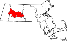 | |
| Towns | ||
| CDPs | ||
| Other villages | ||
| Footnotes | ‡This populated place also has portions in an adjacent county or counties | |