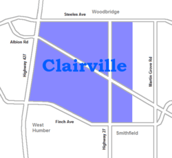
Clairville, Toronto
| Clairville | |
|---|---|
| Neighbourhood | |
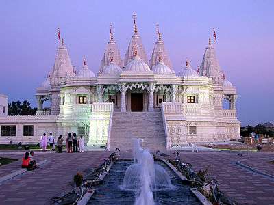 The Hindu Mandir near the West Humber River | |
 | |
| Coordinates: 43°45′00″N 79°38′20″W / 43.75000°N 79.63889°W | |
| Country |
|
| Province |
|
| City |
|
| Community | Etobicoke-York |
| Established | 1849 (Subdivision) |
| Changed Municipality | 1998 Toronto from Etobicoke |
| Government | |
| • MP | Kirsty Duncan (Etobicoke North) |
| • MPP | Shafiq Qaadri (Etobicoke North) |
| • Councillor | Vincent Crisanti (Ward 1 Etobicoke North) |
Clairville is a neighbourhood and former village in the city of Toronto, Ontario, Canada. It is located in the northwest corner of Toronto, in the former city of Etobicoke. Today Clairville is almost wholly industrial/commercial.
History
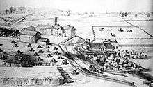
The town of Clairville was established in 1850 at the intersection of Albion Road and Steeles. It was built on a land owned by Jean du Petit Pont de la Haye, a French teacher at Upper Canada College. He developed the community on his estate which he named after his daughter Claire.[1] A private street was built diagonally across northern Etobicoke as a shortcut to Albion Township through Toronto Gore Township (now part of Caledon and Brampton), with a toll at Clairville. The street was originally named Clairville but was also called the Albion Road (the current name for this street).[2]
Re-development
A dam was built on the West Branch of the Humber River immediately west of the village and created Lake Clairville reservoir. Clairville began to disappeared / diminish after the realignment of Albion Road and then the realignment of Steeles Avenue. As a result, by the mid-1980s through traffic was by-passing the community. In the 1970s Highway 427 was built north along the western edge of the neighbourhood and in the 1990s Highway 407 was built just to the north. This combined with the existing rail lines and proximity to Pearson Airport make the area prime industrial land. Today, some of original residential homes have disappeared in the Toronto section of Clairville and replaced with warehousing and open storage / trucking uses. Many of the remaining original homes are no longer used as residences.
Clairville was divided between municipalities, the portion west of Indian Road and Highway 427 is today in Brampton. Unlike in Toronto, Claireville, Brampton largely consists of new residential subdivisions north of Queen Street, Indian Line Campground and the Clairville Conservation Area in the south end.
The area is close to the large south Asian communities of Brampton and Rexdale. The accessible area with large cheap lots has become home to several Hindu temples, most notably the BAPS Shri Swaminarayan Mandir Toronto.
Institutions
- Skyway Industrial Park
- Glendale Memorial Gardens
- Westwood Arena
- Apotex
- HBC warehouse
- Claireville Junior School (GR. JK-05) - A public elementary school that is over 48 years old provides a space for approximately 375 students. Under the Toronto District School Board, this public elementary school that begins from Junior Kindergarten to Grade 5, engages also with the parents/guardians of students, as well as with the community through many partnerships such as Holiday Food Drive with the Daily Bread, Co-op Student placements from local high schools, Teacher Candidates from York University, U of T and other Faculties of Education.
Notes
http://www2.tdsb.on.ca/MOSS/asp_apps/school_landing_page/pdfs/web/2067_4pageLayout.pdf%5Bpermanent+dead+link%5D http://www.tdsb.on.ca/Findyour/Schools.aspx?schno=2067
Places adjacent to Clairville, Toronto | |
|---|---|