St George in the East (parish)
| St George in the East | |
|---|---|
 Cannon Street Road | |
 St George in the East St George in the East shown within Greater London | |
| OS grid reference | TQ355805 |
| London borough | |
| Ceremonial county | Greater London |
| Region | |
| Country | England |
| Sovereign state | United Kingdom |
| Post town | LONDON |
| Postcode district | E1 E1W |
| Dialling code | 020 |
| Police | Metropolitan |
| Fire | London |
| Ambulance | London |
| EU Parliament | London |
| UK Parliament | |
| London Assembly | |
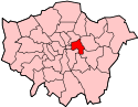
St George in the East is an conservation area[1] and historic Church of England parish in London, England. located in the London Borough of Tower Hamlets and while the name has dropped out of general use, it is still shown on many 21st century maps. The church is still open and holds regular services and does a lot of community organising and social justice campaigns.
History
The parish was largely rural at the time of its creation, the main settlement a hamlet known as Wapping Stepney. The parish church of St George in the East was completed in 1729 by the Commission for Building Fifty New Churches. To distinguish it from other parishes in and near London with the same name, an addition was made which denoted it as " in the East" at the end of St George which took it name from the fact it was then an eastern suburb of the London.[2]
In 1800, work on constructing the London Docks had begun, with parts of Wapping being demolished. In 1820 St. George in the East was at the height of its prosperity, and wealthy merchants and traders resided in the parish. The London Docks caused a large influx of unskilled labour and brought poverty with the population growing dense and causing outbreaks of cholera in 1849, 1855, and in 1866.[3]
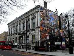
In the 1930s, Sir Oswald Mosley British Union of Fascists organized a march down Cable Street to Stepney with 3,000 supporters in October 1936, which was blocked by protesters’ barricades at the junction of Cable Street and Leman Street in Whitechapel and was known after as the Battle of Cable Street, a mural painted on the side of the former St George’s vestry hall shows this event.[4]
After the devastating bomb damage during the Second World War, St George in the East was redeveloped into an almost entirely residential area, which included high-rise flats being built in the 1970s as the majority of the distinct was absorbed into Shadwell and Whitechapel as St George in the East reseeded into an small neighborhood based around the church, the subsequently London Docklands regeneration has impinged on the parish, without transforming it.[5]
Geography
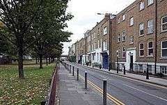
Much of the former northern boundary of the parish was with Mile End Old Town ran alongside Commercial Road. In the west the boundary with Whitechapel fell just short of Back Church Lane. The parish of Wapping bordered it to the south, with Wapping forming a panhandle in the west, dividing it from St Botolph Without Aldgate. The parish of Shadwell was to the east, and the parishes of Wapping and Shadwell almost met, giving St George in the East only a narrow frontage to the River Thames of 53 feet (16 m).
Shadwell and St George's East railway station on the London and Blackwall was within the parish of St George, as was a large part of the London Docks, which have since been filled in. It included parts of the contemporary districts of Shadwell and Wapping.
Governance

St George in the East, once referred to as St George Middlesex; was part of the ancient parish of Stepney in the Tower division of the Ossulstone hundred of Middlesex. It was split off as a separate Civil parish in 1729 and had a population of 47,157 in 1881 and the local government was called the Vestry of the Parish of St George from 1855 to 1900.[6] Following the Poor Law Amendment Act 1834, it was a single parish for Poor Law purposes.
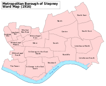
The parish vestry became a local authority in the Metropolis in 1855, nominating one member to the Metropolitan Board of Works. Under the Metropolis Management Act 1855 any parish that exceeded 2,000 ratepayers was to be divided into wards; as such the incorporated vestry of St George in the East was divided into two wards (electing vestrymen): No. 1 or North (18) and No. 2 or South (18).[7]
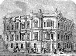
The board of works was replaced by the directly elected London County Council in 1889 and its area of responsibly became the County of London. St George in the East became part of the Metropolitan Borough of Stepney in 1900 and was abolished as a civil parish in 1927. The vestry hall was located on Cable Street and is still in existence.
It was initially part of the Middlesex Parliament constituency and then the Tower Hamlets constituency from 1832 to 1885. A St George constituency was in existence from 1885 to 1918, and then it became part of Whitechapel and St Georges, until it was abolished as a civil parish in 1927 and replaced with the Stepney Borough.
Notable residents
- Lottie Collins, musical hall singer
References
- ↑ https://www.towerhamlets.gov.uk/Documents/Planning-and-building-control/Development-control/Conservation-areas/St-George-in-the-EastV1.pdf
- ↑ "St George in the East". british-history.ac.uk. Retrieved 18 October 2015.
- ↑ http://www.mernick.org.uk/thhol/stgeorge.html
- ↑ http://hidden-london.com/gazetteer/st-george-in-the-east/
- ↑ https://www.hidden-london.com/gazetteer/st-george-in-the-east/amp/
- ↑ Youngs, Frederic A, Jr. (1979). Guide to the Local Administrative Units of England, Vol.I: Southern England. London: Royal Historical Society. ISBN 0-901050-67-9.
- ↑ The London Gazette Issue: 21802. 20 October 1855. pp. 3895–3896. Retrieved 8 April 2015.
| Districts |
|  Headquarters at Spring Gardens |
|---|---|---|
| Incorporated vestries | Original vestries (1855)
Later vestries
| |
| Undertakings | ||
| Major works | ||
| Legislation | ||
| People | ||