Fish Island, London
| Fish Island | |
|---|---|
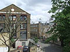 View down Dace Road, Fish Island, with the London Stadium, over the River Lea, in the distance. | |
 Fish Island Fish Island shown within Greater London | |
| London borough | |
| Ceremonial county | Greater London |
| Region | |
| Country | England |
| Sovereign state | United Kingdom |
| Post town | LONDON |
| Postcode district | E3 |
| Dialling code | 020 |
| Police | Metropolitan |
| Fire | London |
| Ambulance | London |
| EU Parliament | London |
| London Assembly | |


Fish Island is a sub-district of Bow in the London Borough of Tower Hamlets in London's East End; it is separated from the rest of the Old Ford area by the Hertford Union Canal to the north and the East Cross Road (A12), constructed in the late 1960s,[1] to the west.
The River Lea Navigation lies to the east with Stratford and the Queen Elizabeth Olympic Park beyond it. It is about 20 hectares (50 acres) in extent.
Nearby Hackney Wick has a similar character to Fish Island and is much better known. This sometimes leads to Fish Island being described as part of Hackney Wick, though the place name Hackney Wick is generally limited to areas within Hackney.
The Fish Island area was originally known to local residents as "the Island" and later Fish Island, in reference to the roads with the names of freshwater fish: Smeed, Dace, Monier, Bream, Roach etc.[1]
History
In the early 12th century a bow-shaped stone bridge was built over the River Lea giving its name to the west bank settlement of Bow.[1] The earlier crossing point, a river ford, half a mile upstream became known as Eldeford or Oldeford by the 13th century.[1] The area north of Old Ford, between the River Lea and Hackney Brook, known as Old Ford Marsh, was intersected by canals and drained in the late 18th and early 19th century, forming the district that now includes Fish Island.[1]
In 1865, a 30-acre plot in Old Ford was purchased to be used as a gas works, but the Gas Light and Coke Company established what would become known as Fish Island, giving it its distinctive road names, and building a mixed residential and industrial development instead.[2] The area saw significant bombing during World War II with damaged housing demolished, post-war, to make way for factories and warehouses.[1]
Industry
Before World War II Fish Island was a mainly, but not exclusively, industrial area. After the war the area was devoted entirely to industry which subsequently went into decline.
Current industry
Notable current firms include the revived Truman's Brewery and H. Forman and Son.
Smoked salmon producer H. Forman and Son has been based in the area since 1971, at Queens Yard, Hackney Wick. Together with its sister business Forman and Field, producers of gourmet food, it was forced to relocate out of the area following a flood when the Hackney Cut (part of the River Lea Navigation) overflowed and flooded Queens Yard. It moved to nearby Marshgate Lane, but within one year of relocating, it was forced to move again as its newly built factory was located on what was to become the running track of the Olympic Stadium. In October 2007 it relocated back to Fish Island and its new premises were officially opened by the Mayor of London, Boris Johnson. The site offers a view of the Olympic stadium and has a restaurant and hospitality venue in addition to the smoke-house and kitchens, and also an art gallery to support the work of the local art community.
Former industries
The Percy Dalton Peanut Factory was based in Fish Island, occupying Britannia Works and gatehouse along Dace Road, and another building on Smeed Road. Britannia Works has been run as an artists studio building by SPACE (studios) since 2000[3].
Arts
Fish Island has a long tradition as a home to artists and art spaces.[4] The Island, and adjoining Hackney Wick, has 'one of the highest densities of fine artists, designers and artisans in Europe', with a 2009 study identifying around 600 artists' studios.[5]
The London Centre for Book Arts has been based in the Britannia Works building (part of SPACE (studios)) since 2012. The first and only centre of its kind in the UK, the Centre’s mission is to foster and promote book arts and artist-led publishing in the UK through collaboration, education, distribution, and by providing open-access to printing, binding and publishing facilities. [6] [7] [8]
In 2014, a partnership between tech hub The Trampery and the Barbican Centre, led to the establishment of Fish Island Labs, a mentored art and technology project. The Labs will allow 40 to 50 participants, for ten months, to share a low-cost workspace in a converted Fish Island warehouse.[4]
Channel 4’s Big Breakfast was broadcast from the Lock Keeper's Cottage at Fish Island from 1992 to 2002.
Redevelopment
Once a largely industrial area, the island is currently going through a major regeneration, though numerous industrial units remain. This is partially credited to its proximity to the Olympic Park, on the opposite bank of the Lea. It is home to a mixture of factories, residential flats and, more recently, studios and workshops for those working in creative industries. The local planning authority intends to see it developed as a mixed-use community with further land used for housing, employment and open space, and improved access links.[9]
Fish Island is home to the Percy Dalton Peanut Factory which has now been largely converted into artist studios.
Transport
Rail
There are no stations in the area. However, Hackney Wick for London Overground in Hackney Wick and Pudding Mill Lane for the Docklands Light Railway in Stratford are nearby.
Buses
London Buses 276, 339, 488 operate within Fish Island.
Road
Fish Island is connected to the National Road Network by the north/north east-south A12 (also known as the East Cross Route).
Walking and cycling
The Greenway starts on Wick Lane and there is a footbridge over the East Cross Route linking Old Ford and Bow. The Hertford Union Canal and Lea River Navigation towpaths pass north and east of Fish Island and the National Cycle Route 1 also passes the north on the Hertford Union Canal towpath.
Waterways
The Hertford Union Canal and River Lea Navigation pass north and east of the area.
Sport
Home to Fish Island Football Club (est. 2014).
Nearest places
- Bow
- Hackney Wick
- Queen Elizabeth Olympic Park
- Stratford
- Stratford Marsh
- Old Ford
- Victoria Park
References
- 1 2 3 4 5 6 "Fish Island Conservation Area". Tower Hamlets London Borough Council. Retrieved 2014-09-06.
- ↑ Bridget Cherry; Charles O'Brien; Nikolaus Pevsner (2005). London: East. Yale University Press. p. 626. ISBN 978-0-300-10701-2.
- ↑ http://www.spacestudios.org.uk/archive-studios/the-cut-oral-histories-4-2-9-5/
- 1 2 Curtis, Nick (2014-06-27). "Fish Island Labs: the Barbican's fuzzy new frontier where art and technology meet". London Evening Standard. Retrieved 2014-09-06.
- ↑ "Creative. Connected. World Class. East Wick and Sweetwater. Development opportunity on Queen Elizabeth Olympic Park" (PDF). London Legacy Development Corporation. Retrieved 2014-09-06.
- ↑ https://www.theguardian.com/artanddesign/2013/jan/01/new-chapter-centre-book-arts
- ↑ https://www.ft.com/content/bc7fcfd6-96cf-11e2-a77c-00144feabdc0
- ↑ https://londonbookarts.org/about/
- ↑ Davies, Lizzy (2011-07-17). "How power, money and art are shifting to the East End". The Observer. Guardian Media Group. Retrieved 2014-09-06.
External links
- Fish Island at HiddenLondon.com
- Mapping the Change: Old Ford Voices & Island Memories at Tower Hamlets Borough Council 'Idea'.