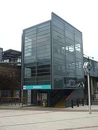
Westferry DLR station
| Westferry | |
|---|---|
 Eastside of Westferry station | |
 Westferry Location of Westferry in Greater London | |
| Location | Limehouse |
| Local authority | London Borough of Tower Hamlets |
| Managed by | Docklands Light Railway |
| Number of platforms | 2 |
| Accessible | Yes[1] |
| Fare zone | 2 |
| DLR annual boardings and alightings | |
| 2012 |
|
| 2013 |
|
| 2014 |
|
| 2015 |
|
| 2016 |
|
| Key dates | |
| 1987 | Opened |
| Other information | |
| Lists of stations | |
| WGS84 | 51°30′34″N 0°01′36″W / 51.509372°N 0.026697°WCoordinates: 51°30′34″N 0°01′36″W / 51.509372°N 0.026697°W |
|
| |
Westferry is a station on the Docklands Light Railway (DLR), at the junction of Limehouse Causeway and Westferry Road in Limehouse in London Docklands, England. The station is located in Travelcard Zone 2.[5] To the west is Limehouse station, whilst to the east the DLR splits, with one branch going to Poplar station and the other to West India Quay station.
Location
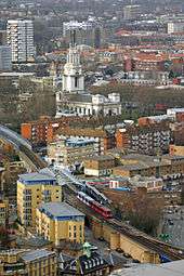
The DLR station was built midway between the site of the old Limehouse and West India Docks stations on the disused London and Blackwall Railway. Limehouse Police Station is nearby, as is St Anne's Church, built by Nicholas Hawksmoor and boasting London's tallest church clock tower. The station is also close to Westferry Circus and Canary Wharf Pier.
Etymology
Westferry station is in Limehouse and given its proximity to the former Limehouse station on the London & Blackwall Railway, could have been given this name, but instead Stepney East was renamed Limehouse and the DLR station there given that name. West India Quay was reserved for the station at the other end of West India Dock, so there was no obvious choice.
There is no place called Westferry; the name is derived from the nearby Westferry Road. Nor was there ever a west ferry. There was a passenger ferry at the southern tip of The Isle of Dogs run by the Greenwich watermen. It was accessed by two roads, East Ferry Road (also known locally as Farm Road) and Westferry Road, built in 1812 when a horse ferry was introduced alongside the passenger ferry. The two roads still exist, running down the centre and west side of the Isle of Dogs respectively. But the road names refer to an ancient service at the far end of the Isle of Dogs from the station.
| Preceding station | Following station | |||
|---|---|---|---|---|
| Docklands Light Railway | ||||
towards Bank | Docklands Light Railway | towards Lewisham |
||
(eastbound West India Quay Bypass) towards Lewisham |
Connections
London Buses services serves the station, key route 135, local routes 277, D3 and D7, night routes N277 and N550.[6]
References
- ↑ "Step free Tube Guide" (PDF). Transport for London. Archived (PDF) from the original on 13 June 2018.
- ↑ Transport for London (12 February 2013). "Freedom of Information DLR usage 1213". Transport for London. Retrieved 10 November 2013.
- 1 2 3 "Up-to-date DLR entry/exit statistics for each station" (XLSX). What Do They Know. Transport for London. 18 March 2016. Retrieved 2 April 2016.
- ↑ "Passenger Numbers - Docklands Light Railway Limited" (XLSX (after downloading zip)). What Do They Know. Transport for London. 8 June 2017. Retrieved 11 September 2017.
- ↑ Transport for London. "Westferry DLR Station". Transport for London.
- ↑ Transport for London. "Westferry Station". Transport for London.
External links
| Wikimedia Commons has media related to Westferry DLR station. |
| Stations |
| ||||||||||||
|---|---|---|---|---|---|---|---|---|---|---|---|---|---|
| Future |
| ||||||||||||
| Rolling stock |
| ||||||||||||
| |||||||||||||