Lake Hāwea
| Lake Hāwea | |
|---|---|
 | |
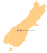
| Location | Queenstown-Lakes District, Otago Region, South Island |
| Coordinates | 44°30′S 169°17′E / 44.500°S 169.283°ECoordinates: 44°30′S 169°17′E / 44.500°S 169.283°E |
| Primary inflows | Hunter River |
| Primary outflows | Hāwea River |
| Basin countries | New Zealand |
| Surface area | 141 km2 (54 sq mi) |
| Max. depth | 392 m (1,286 ft) |
| Surface elevation | 348 m (1,142 ft) |
| Islands | Silver Island |
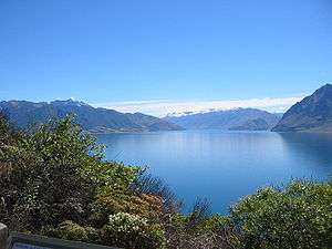
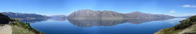
Lake Hāwea is located in the Otago Region of New Zealand, at an altitude of 348 metres. It covers an area of some 141 km² and is, at its deepest, 392 metres deep.
Lake Hāwea is named after a Māori tribe who preceded the Waitaha people in the area.[1] The spelling "Hawea" (without a macron) is common in New Zealand English.
At its greatest extent, which is roughly along a north-south axis, Lake Hāwea is 35 kilometres long. It lies in a glacial valley formed during the last ice age, and is fed by the Hunter River. Nearby Lake Wanaka lies in a parallel glacial valley eight kilometres to the west. At their closest point (a rocky ridge called The Neck), the lakes are only 1000 metres apart.
Lake Hāwea is dammed to the south by an ancient terminal moraine created some 10,000 years ago. In 1958 the lake was artificially raised by 20 metres to store more water for increased hydroelectric power generation at the Roxburgh Dam.[2]
The only flat land around the lake is at its southern end, surrounding its outflow into the Hāwea River, a short tributary of the Clutha / Matau-au, which it joins near Albert Town. The settlement of Hāwea is found at the lake's southern shore.
The lake is a popular resort, and is well used in the summer for fishing, boating and swimming. The nearby mountains and fast-flowing rivers allow for adventure tourism year-round, with jetboating and skiing nearby.
Māori history
For Māori, the Wanaka and Hāwea area was a natural crossroads. The Haast Pass led to the West Coast and its pounamu; the Cardrona Valley led to the natural rock bridge "Whatatorere" which was the only place that the Kawarau River and Clutha River / Mata-Au could be crossed without boats.[1] Reed boats enabled a swift return downriver to the east coast.
The Cromwell basin supported a large population of moa, which were hunted to extinction about 500 years ago.[1]
Until the early nineteenth century, the area was visited annually by Ngai Tahu who sought pounamu in the mountains above the Haast River and hunted eels and birds over summer, returning to the east coast by descending the Clutha River / Mata-Au in reed boats.[3] Ngai Tahu use of the land was ended by attacks by North Island tribes.[1] In 1836, the Ngati Tama chief Te Puoho led a 100-person war party, armed with muskets, down the West Coast and over the Haast Pass: they fell on the Ngai Tahu encampment between Lake Wanaka and Lake Hawea, capturing 10 people and killing and eating two children.[4] Although Te Puoho was later killed by the southern Ngai Tahu leader Tuhawaiki,[5] Maori seasonal visits to the area ceased.
The first European to see the lake was Nathaniel Chalmers in 1853.[6] Guided by Reko and Kaikoura, he walked from Tuturau (Southland) to the lakes via the Kawarau River. He was stricken by dysentery, so his guides returned him down the Clutha in a reed boat.[7]
Namesakes
There have been three Royal New Zealand Navy ships named after the lake, one of which is active still in service.
See also
References
- 1 2 3 4 Janet Stephenson, Heather Bauchop, and Peter Petchey (2004). Bannockburn Heritage Landscape Study (PDF). p. 29.
- ↑ Malcolm McKinnon (2009). "Otago places - Clutha River/Mata-Au". Te Ara - the Encyclopedia of New Zealand. Retrieved 13 July 2017.
- ↑ Malcolm McKinnon (2009). "Otago region - Māori history and whaling". Te Ara - the Encyclopedia of New Zealand. Retrieved 2017-07-11.
- ↑ S Percy Smith (1910). History and Traditions of the Maoris of the West Coast North Island of New Zealand Prior to 1840. New Plymouth: Polynesian Society.
- ↑ Atholl Anderson (1990). "Te Puoho-o-te-rangi". Te Ara - the Encyclopedia of New Zealand,. 1. Retrieved 2017-07-11.
- ↑ Jock Phillips (2006). "European exploration - Otago and Southland". Te Ara - the Encyclopedia of New Zealand. Retrieved 2017-07-11.
- ↑ Roger Frazer (1990). "Chalmers, Nathanael". Te Ara - the Encyclopedia of New Zealand. Dictionary of New Zealand Biography. 1. Retrieved 13 July 2017.
Other sources
- Wise's New Zealand guide: A gazetteer of New Zealand (4th ed.) (1969) Dunedin: H. Wise & Co. (N.Z.) Ltd.
- Encyclopædia Britannica. Retrieved February, 2006, from Encyclopædia Britannica Premium Service.