Vignory
| Vignory | |
|---|---|
| Commune | |
 Vignory Location within Grand Est region  Vignory | |
| Coordinates: 48°16′44″N 5°06′14″E / 48.2789°N 5.1039°ECoordinates: 48°16′44″N 5°06′14″E / 48.2789°N 5.1039°E | |
| Country | France |
| Region | Grand Est |
| Department | Haute-Marne |
| Arrondissement | Chaumont |
| Canton | Bologne |
| Intercommunality | Communauté de communes du Bassin de Bologne Vignory et Froncles |
| Government | |
| • Mayor (2008–2014) | Francis Majorkewiez |
| Area1 | 19.46 km2 (7.51 sq mi) |
| Population (1999)2 | 307 |
| • Density | 16/km2 (41/sq mi) |
| Time zone | UTC+1 (CET) |
| • Summer (DST) | UTC+2 (CEST) |
| INSEE/Postal code | 52524 /52320 |
| Elevation |
217–389 m (712–1,276 ft) (avg. 243 m or 797 ft) |
|
1 French Land Register data, which excludes lakes, ponds, glaciers > 1 km2 (0.386 sq mi or 247 acres) and river estuaries. 2 Population without double counting: residents of multiple communes (e.g., students and military personnel) only counted once. | |
Vignory is a commune in the Haute-Marne département in north-eastern France.
Sites and monuments
- Château de Vignory - castle built at the start of the 12th century by Guy de Vignory; classified as a monument historique in 1989.[1]
- Église Saint-Étienne de Vignory - church whose construction began in 1032; classified as a monument historique in 1846.[2]
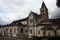
Église Saint-Étienne de Vignory
- Picturesque streets
- Museum and medieval-inspired garden
- 16th and 18th century houses
- Lavoir - constructed 1832
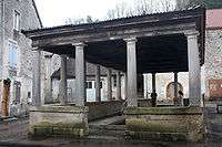
Lavoir
See also
References
- ↑ Ministry of Culture: Vignory - Ancien château fort
- ↑ Ministry of Culture: Vignory - Eglise
External links
| Wikimedia Commons has media related to Vignory. |
- Ministry of Culture: Photos of church
- Vignory on the Ministry of Culture's historic monuments database
This article is issued from
Wikipedia.
The text is licensed under Creative Commons - Attribution - Sharealike.
Additional terms may apply for the media files.