Fayl-Billot
| Fayl-Billot | |
|---|---|
| Commune | |
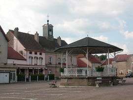 Place de la Mairie de Fayl-Billot | |
 Fayl-Billot Location within Grand Est region  Fayl-Billot | |
| Coordinates: 47°46′58″N 5°36′06″E / 47.7828°N 5.6017°ECoordinates: 47°46′58″N 5°36′06″E / 47.7828°N 5.6017°E | |
| Country | France |
| Region | Grand Est |
| Department | Haute-Marne |
| Arrondissement | Langres |
| Canton | Chalindrey |
| Intercommunality | Communauté de communes du Pays Vannier |
| Government | |
| • Mayor (2008–2014) | François Girod |
| Area1 | 42.9 km2 (16.6 sq mi) |
| Population (1999)2 | 1,419 |
| • Density | 33/km2 (86/sq mi) |
| Demonym(s) | Fayl-Billotins, Fayl-Billotines |
| Time zone | UTC+1 (CET) |
| • Summer (DST) | UTC+2 (CEST) |
| INSEE/Postal code | 52197 /52500 |
| Elevation |
234–387 m (768–1,270 ft) (avg. 333 m or 1,093 ft) |
|
1 French Land Register data, which excludes lakes, ponds, glaciers > 1 km2 (0.386 sq mi or 247 acres) and river estuaries. 2 Population without double counting: residents of multiple communes (e.g., students and military personnel) only counted once. | |
Fayl-Billot is a commune in the Haute-Marne department in north-eastern France.
See also
| Wikimedia Commons has media related to Fayl-Billot. |
This article is issued from
Wikipedia.
The text is licensed under Creative Commons - Attribution - Sharealike.
Additional terms may apply for the media files.