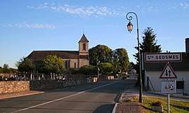
Saints-Geosmes
| Saints-Geosmes | |
|---|---|
| Commune | |
 | |
 Saints-Geosmes Location within Grand Est region  Saints-Geosmes | |
| Coordinates: 47°49′58″N 5°19′41″E / 47.8328°N 5.3281°ECoordinates: 47°49′58″N 5°19′41″E / 47.8328°N 5.3281°E | |
| Country | France |
| Region | Grand Est |
| Department | Haute-Marne |
| Arrondissement | Langres |
| Canton | Langres |
| Government | |
| • Mayor | Jacky Maugras |
| Area1 | 27.61 km2 (10.66 sq mi) |
| Population (2013)2 | 1,155 |
| • Density | 42/km2 (110/sq mi) |
| Time zone | UTC+1 (CET) |
| • Summer (DST) | UTC+2 (CEST) |
| INSEE/Postal code | 52449 /52200 |
| Elevation |
373–476 m (1,224–1,562 ft) (avg. 458 m or 1,503 ft) |
|
1 French Land Register data, which excludes lakes, ponds, glaciers > 1 km2 (0.386 sq mi or 247 acres) and river estuaries. 2 Population without double counting: residents of multiple communes (e.g., students and military personnel) only counted once. | |
Saints-Geosmes is a commune in the Haute-Marne department in north-eastern France. On 1 January 2016, the former commune Balesmes-sur-Marne was merged into Saints-Geosmes.[1]
See also
References
- ↑ Arrêté préfectoral 21 December 2015 (in French)
| Wikimedia Commons has media related to Saints-Geosmes. |
This article is issued from
Wikipedia.
The text is licensed under Creative Commons - Attribution - Sharealike.
Additional terms may apply for the media files.