Auberive
| Auberive | |
|---|---|
| Commune | |
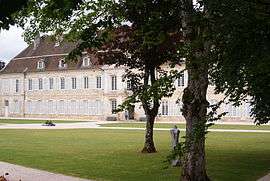 Château d'Auberive | |
 Auberive Location within Grand Est region  Auberive | |
| Coordinates: 47°47′16″N 5°03′46″E / 47.7878°N 5.0628°ECoordinates: 47°47′16″N 5°03′46″E / 47.7878°N 5.0628°E | |
| Country | France |
| Region | Grand Est |
| Department | Haute-Marne |
| Arrondissement | Langres |
| Canton | Villegusien-le-Lac |
| Intercommunality | CC Auberive Vingeanne Montsaugeonnais |
| Government | |
| • Mayor (2014-2020) | Bernard Meyer |
| Area1 | 70.64 km2 (27.27 sq mi) |
| Population (2015)2 | 193 |
| • Density | 2.7/km2 (7.1/sq mi) |
| Time zone | UTC+1 (CET) |
| • Summer (DST) | UTC+2 (CEST) |
| INSEE/Postal code | 52023 /52160 |
| Elevation |
325–504 m (1,066–1,654 ft) (avg. 365 m or 1,198 ft) |
|
1 French Land Register data, which excludes lakes, ponds, glaciers > 1 km2 (0.386 sq mi or 247 acres) and river estuaries. 2 Population without double counting: residents of multiple communes (e.g., students and military personnel) only counted once. | |
Auberive is a commune in the Haute-Marne department in the Grand Est region in northeastern France.
Geography
The Aujon flows west through the northeastern part of the commune.
The Aube forms part of the commune's southern border, then flows northwest through the western part of the commune, where it crosses the village.
Population
| Historical population | ||
|---|---|---|
| Year | Pop. | ±% |
| 1962 | 263 | — |
| 1968 | 302 | +14.8% |
| 1975 | 270 | −10.6% |
| 1982 | 219 | −18.9% |
| 1990 | 233 | +6.4% |
| 1999 | 205 | −12.0% |
| 2006 | 195 | −4.9% |
| 2009 | 195 | +0.0% |
| 2015 | 193 | −1.0% |
Images
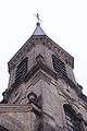 Church
- Chateau Auberive
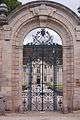 Gate to the Chateau
.jpg)
See also
External links
| Wikimedia Commons has media related to Auberive. |
This article is issued from
Wikipedia.
The text is licensed under Creative Commons - Attribution - Sharealike.
Additional terms may apply for the media files.