Cirey-sur-Blaise
| Cirey-sur-Blaise | ||
|---|---|---|
| Commune | ||
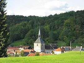 Village de Cirey-sur-Blaise | ||
| ||
 Cirey-sur-Blaise Location within Grand Est region  Cirey-sur-Blaise | ||
| Coordinates: 48°19′59″N 4°56′29″E / 48.3331°N 4.9414°ECoordinates: 48°19′59″N 4°56′29″E / 48.3331°N 4.9414°E | ||
| Country | France | |
| Region | Grand Est | |
| Department | Haute-Marne | |
| Arrondissement | Saint-Dizier | |
| Canton | Joinville | |
| Government | ||
| • Mayor | Hugues De Salignac | |
| Area1 | 16.44 km2 (6.35 sq mi) | |
| Population (2006)2 | 110 | |
| • Density | 6.7/km2 (17/sq mi) | |
| Time zone | UTC+1 (CET) | |
| • Summer (DST) | UTC+2 (CEST) | |
| INSEE/Postal code | 52129 /52110 | |
| Elevation |
216–328 m (709–1,076 ft) (avg. 233 m or 764 ft) | |
|
1 French Land Register data, which excludes lakes, ponds, glaciers > 1 km2 (0.386 sq mi or 247 acres) and river estuaries. 2 Population without double counting: residents of multiple communes (e.g., students and military personnel) only counted once. | ||
.svg.png)
Cirey-sur-Blaise is a commune in the Haute-Marne department in north-eastern France.
Geography
The river Blaise flows through the commune.
See also
| Wikimedia Commons has media related to Cirey-sur-Blaise. |
| Authority control |
|---|
This article is issued from
Wikipedia.
The text is licensed under Creative Commons - Attribution - Sharealike.
Additional terms may apply for the media files.