Vardø
| Vardø kommune Várggát (Northern Sami) Vuorea (Kven) Vuoreija (Finnish) | |||
|---|---|---|---|
| Municipality | |||
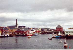
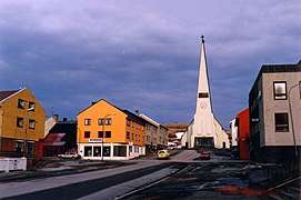
 View of Vardø | |||
| |||
 Vardø within Finnmark | |||
| Coordinates: 70°22′14″N 31°01′27″E / 70.37056°N 31.02417°ECoordinates: 70°22′14″N 31°01′27″E / 70.37056°N 31.02417°E | |||
| Country | Norway | ||
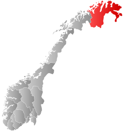
| County | Finnmark | ||
| District | Øst-Finnmark | ||
| Established | 1 Jan 1838 | ||
| Administrative centre | Vardø | ||
| Government | |||
| • Mayor (2015) | Robert Jensen (Labour Party (Norway)) | ||
| Area | |||
| • Total | 600.61 km2 (231.90 sq mi) | ||
| • Land | 585.59 km2 (226.10 sq mi) | ||
| • Water | 15.02 km2 (5.80 sq mi) 2.5% | ||
| Area rank | #186 in Norway | ||
| Population (2017) | |||
| • Total |
2,104 ( | ||
| • Rank | #322 in Norway | ||
| • Density | 3.6/km2 (9/sq mi) | ||
| • Change (10 years) | −8.0% | ||
| Demonym(s) | Vardøværing[1] | ||
| Time zone | UTC+01:00 (CET) | ||
| • Summer (DST) | UTC+02:00 (CEST) | ||
| ISO 3166 code | NO-2002 | ||
| Official language form | Bokmål | ||
| Website |
vardo | ||
![]()
The 601-square-kilometre (232 sq mi) municipality is the 186th largest by area out of the 422 municipalities in Norway. Vardø is the 322nd most populous municipality in Norway with a population of 2,104. The municipality's population density is 3.6 inhabitants per square kilometre (9.3/sq mi) and its population has decreased by 8% over the last decade.[2]
General information
The town of Vardø and the rural district around it was established as a municipality on 1 January 1838 (see formannskapsdistrikt). The law required that all towns should be separated from their rural districts, but because of a low population and very few voters, this was impossible to carry out for Vardø in 1838. (See also Hammerfest and Vadsø.) The rural district of Vardø (Vardø landdistrikt, which was renamed Båtsfjord in 1957) was officially separated from the town of Vardø in 1868. During the 1960s, there were many municipal mergers across Norway due to the work of the Schei Committee. On 1 January 1964, the eastern part of Båtsfjord was merged with the town of Vardø to create today's Vardø Municipality.[3]
Name
The Old Norse form of the name was Vargøy. The first element is vargr which means "wolf" and the last element is øy which means "island". The first element was later replaced (around 1500) with varða which means "cairn". Historically, the name was spelled Vardöe.[4][5]
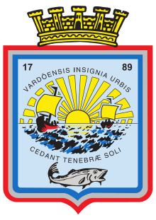
Coat of arms
The Coat of arms date back to 1898. Its borders are drawn using the national colours: red, white, and blue. The border frames the shield, and the centre field shows a complex scene incorporating a sunrise with rays, two fishing boats with crews, the sea with waves, and a large cod. In the chief we find the year of the town's foundation, 1789, together with the words "Vardöensis Insignia Urbis", meaning "the seal of the town of Vardø". In the lower part of the arms, we find the town motto: "Cedant Tenebræ Soli", meaning "Darkness shall give way to the sun."[6][7] This is a high resolution version of the coat of arms.
Churches
The Church of Norway has one parish (sokn) within the municipality of Vardø. It is part of the Varanger prosti (deanery) in the Diocese of Nord-Hålogaland.
| Parish (sokn) | Name | Location | Year built |
|---|---|---|---|
| Vardø | Vardø Church | Vardø | 1958 |
| Vardø Chapel | Vardø | 1908 |
History
Vardø has a long settlement history before it was granted status as a town in 1789. Several stone-age sites as well as sites dating from the Sami Iron Age are known on the island. In the Medieval period, Vardø's importance grew as a result of it being the easternmost stronghold of the then-expanding Norwegian royal power. A church was built in Vardø in 1307, and the first fortress was established at about the same time. Thick cultural layers in the southeastern part of the town, Østervågen, document continuous habitation in this area reaching back at least some 800 years.
Even if the presence of the fortress and king's bailiff gave Vardø a certain degree of permanence and stability not experienced by other fishing communities in Finnmark, the town's size and importance waxed and waned with the changing fortunes of the fisheries. In the mid-16th century Vardø had a population of 400 to 500 people. By 1789, however, it had reduced to about 100.
In the 17th century, Vardø was the center of a great number of witchcraft trials. More than 90 persons, Norwegian and Sami, were given death sentences.
After 1850, the town saw a marked expansion. The fisheries grew in importance, and so did the Pomor trade with Russia's White Sea region. In 1850 the population reached 400, and in 1910 it passed 3 000.
During World War II, with Norway occupied by the German Wehrmacht, Vardø was heavily bombed by Allied, mostly Russian forces. Most of the town center was destroyed, and the population was evacuated. After the war, the city center was completely reconstructed. However, older, traditional houses survived in the periphery, such as in the old town in Østervågen.
As of 2017, the fishing industry had collapsed. From 1995 to 2017, the population shrunk by 50 percent to 2,100 people. In May 2017 work to lay a new electric cable from the Norwegian mainland to the island began. The additional electricity is needed to power an American-funded radar system located about 40 miles from Russia's Kola Peninsula, a territory studded with high-security naval bases and restricted military zones. The secrecy surrounding the radar systems has spawned fears that officials are covering up health hazards and other possible dangers. The electromagnetic pulses emitted by the current radar system interfere with television and radio reception and have been blamed by some residents for a rash of miscarriages and cancer cases in a civilian district next to the fenced-in security zone.[8]
The town was selected as the millennium site for Finnmark county.
Government
All municipalities in Norway, including Vardø, are responsible for primary education (through 10th grade), outpatient health services, senior citizen services, unemployment and other social services, zoning, economic development, and municipal roads. The municipality is governed by a municipal council of elected representatives, which in turn elect a mayor.[9] The municipality falls under the Øst-Finnmark District Court and the Hålogaland Court of Appeal.
Municipal council
The municipal council (Kommunestyre) of Vardø is made up of 19 representatives that are elected to four year terms. Currently, the party breakdown is as follows:[10]
| Party Name | Name in Norwegian | Number of representatives | |
|---|---|---|---|
| Labour Party | Arbeiderpartiet | 10 | |
| Progress Party | Fremskrittspartiet | 1 | |
| Conservative Party | Høyre | 2 | |
| Green Party | Miljøpartiet De Grønne | 3 | |
| Liberal Party | Venstre | 2 | |
| Local Lists | Lokale lister | 1 | |
| Total number of members: | 19 | ||
Geography
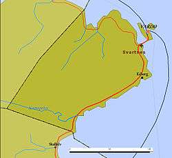
Vardø is the easternmost town in Norway and the Nordic countries, located at 31°E, which is east of Saint Petersburg, Kiev and Istanbul. The eastern part of Finnmark is in the same time zone as the rest of the country, even if it is more than an hour at odds with daylight hours. The town itself is on the island of Vardøya, but the municipality includes significant area on the mainland of the Varanger Peninsula, including part of the Varangerhalvøya National Park in the southwest.
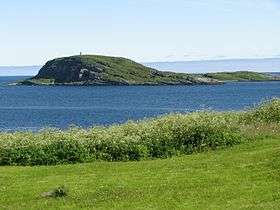
The mountain Domen lies on the shore of the Varanger Peninsula. South of that mountain lies the small Kibergsneset peninsula where the village of Kiberg is located. The town lies on the island of Vardøya, which is surrounded by a few smaller islands. Hornøya is one of those islands. It lies to the northeast of Vardøya and it is the site of Vardø Lighthouse. The mouth of the Varangerfjorden lies along the eastern coast of the municipality.
Climate
The port of Vardø, on the Barents Sea, remains ice-free all year round thanks to the effect of the warm North Atlantic drift. Vardø has a tundra climate (Köppen: ETf).[11] that borders on a subarctic climate (Köppen: Dfc). Excluding high mountain areas, Vardø is the only town in Norway proper that has polar climate. As its warmest month does not reach 10 °C, the minimum temperature required for tree growth, the land is tundra and is treeless. The "midnight sun" is above the horizon from 16 May to 29 July, and the period with continuous daylight lasts a bit longer, polar night from 24 November to 19 January.
| Climate data for Vardø (1981-2010) | |||||||||||||
|---|---|---|---|---|---|---|---|---|---|---|---|---|---|
| Month | Jan | Feb | Mar | Apr | May | Jun | Jul | Aug | Sep | Oct | Nov | Dec | Year |
| Record high °C (°F) | 7.3 (45.1) |
6.7 (44.1) |
8.4 (47.1) |
13.3 (55.9) |
21.1 (70) |
25.8 (78.4) |
27.0 (80.6) |
25.1 (77.2) |
19.9 (67.8) |
13.8 (56.8) |
10.4 (50.7) |
7.3 (45.1) |
27 (80.6) |
| Average high °C (°F) | −1.8 (28.8) |
−2.2 (28) |
−0.8 (30.6) |
1.7 (35.1) |
5.1 (41.2) |
8.8 (47.8) |
11.9 (53.4) |
11.7 (53.1) |
9.1 (48.4) |
4.8 (40.6) |
1.0 (33.8) |
−0.7 (30.7) |
4.1 (39.4) |
| Daily mean °C (°F) | −4.2 (24.4) |
−4.6 (23.7) |
−2.8 (27) |
−0.2 (31.6) |
3.2 (37.8) |
6.8 (44.2) |
9.8 (49.6) |
9.8 (49.6) |
7.3 (45.1) |
3.1 (37.6) |
−1.0 (30.2) |
−3.0 (26.6) |
2.1 (35.8) |
| Average low °C (°F) | −6.6 (20.1) |
−6.9 (19.6) |
−4.8 (23.4) |
−2.1 (28.2) |
1.4 (34.5) |
4.7 (40.5) |
7.7 (45.9) |
7.8 (46) |
5.4 (41.7) |
1.3 (34.3) |
−2.9 (26.8) |
−5.4 (22.3) |
0.0 (32) |
| Record low °C (°F) | −22.5 (−8.5) |
−22.7 (−8.9) |
−20.5 (−4.9) |
−14.1 (6.6) |
−10.3 (13.5) |
−3.9 (25) |
−1.6 (29.1) |
−0.4 (31.3) |
−4.8 (23.4) |
−13.2 (8.2) |
−14.8 (5.4) |
−28.9 (−20.1) |
−28.9 (−20.1) |
| Average precipitation mm (inches) | 61.2 (2.409) |
51.4 (2.024) |
42.2 (1.661) |
41.0 (1.614) |
33.8 (1.331) |
42.3 (1.665) |
59.6 (2.346) |
55.5 (2.185) |
46.6 (1.835) |
70.1 (2.76) |
58.3 (2.295) |
61.6 (2.425) |
623.7 (24.555) |
| Average precipitation days (≥ 1 mm) | 15.3 | 12.5 | 11.6 | 10.5 | 8.5 | 7.8 | 8.6 | 8.9 | 10.7 | 14.8 | 13.4 | 14.4 | 137.4 |
| Source #1: Norwegian Meteorological Institute[12] | |||||||||||||
| Source #2: Météo Climat [13] | |||||||||||||
Fauna and flora
The municipality of Vardø with its seabird colonies of Hornøya and Reinøya are amongst the most interesting on this part of the coast. There is a small breeding population of Brunnich's guillemot as well as larger numbers of razorbill and common guillemot.
The climate is too cold in summer and too windy in winter for trees. However a few planted trees exist in wind-sheltered locations, generally rowans (See the tourism section).
Transportation
The island is connected to the mainland via the undersea Vardø Tunnel (Norway's first such structure). The town's Vardø Airport and the settlement of Svartnes are located on the mainland opposite the tunnel entrance. Vardø is a port of call on Norway's Hurtigruten ferry service. The town is the northern termination of European route E75, which starts in Sitia, Crete.
Media
The newspaper Østhavet has been published in Vardø since 1997.[14]
Economy and tourism
Fishing and seafood processing remain Vardø's major sources of income, although tourism is starting to become an important economic factor.
Vardø's tourist attractions include the Vardøhus Festning, a fortress dating back to the 14th century (although the present structure dates from 1734); the witchcraft trials memorial; several sea bird colonies; two museums: the Pomor Museum and the Partisan Museum; and remnants of German fortifications from World War II. The Yukigassen competition in Vardø is unique in Norway.
Vardøhus Festning is home to two rowan trees which are diligently nurtured and warmed in winter since these trees cannot normally survive in Vardø's cold climate, north of the Arctic tree line. Originally, seven trees were planted in 1960; the one that survived managed to blossom twice, in 1974 and 1981. The tree finally succumbed to cold weather in 2002, but two new saplings have been planted in its place.
In the summer of 2012, Vardø hosted the urban art event Komafest, where 12 international artists painted tens of the town's abandoned houses in a three-week period.
River fishing
Fishing permits (for salmon fishing) are sold for use on specific rivers, including Komag-elva.[15]
Globus II Radar
Since 1998, the town has housed a radar installation called Globus II. Its official purpose is the tracking of space junk; however, due to the site's proximity to Russia, and an alleged connection between the Globus II system and US anti-missile systems, the site has been the basis for heated controversy in diplomatic and intelligence circles.[16]
Sister cities
References
- ↑ "Navn på steder og personer: Innbyggjarnamn" (in Norwegian). Språkrådet. Retrieved 2015-12-01.
- ↑ Statistisk sentralbyrå (2017). "Table: 06913: Population 1 January and population changes during the calendar year (M)" (in Norwegian). Retrieved 2017-09-09.
- ↑ Jukvam, Dag (1999). "Historisk oversikt over endringer i kommune- og fylkesinndelingen" (PDF) (in Norwegian). Statistisk sentralbyrå.
- ↑ Store norske leksikon. "Vardø" (in Norwegian). Retrieved 2013-03-02.
- ↑ Rygh, Oluf (1924). Norske gaardnavne: Finmarkens amt (in Norwegian) (18 ed.). Kristiania, Norge: W. C. Fabritius & sønners bogtrikkeri. p. 301.
- ↑ "Kommunevåpen". Flags of the World. 28 June 2002. Archived from the original on 19 April 2008. Retrieved 13 December 2008.
- ↑ "Civic heraldry of Norway - Norske Kommunevåpen". Heraldry of the World. Retrieved 2018-06-05.
- ↑ Higgins, Andrew (2017-06-14). "On a Tiny Norwegian Island, America Keeps an Eye on Russia". New York Times. Retrieved 2018-05-27.
- ↑ Hansen, Tore, ed. (2016-05-12). "kommunestyre". Store norske leksikon (in Norwegian). Kunnskapsforlaget. Retrieved 2018-06-05.
- ↑ "Table: 04813: Members of the local councils, by party/electoral list at the Municipal Council election (M)" (in Norwegian). Statistics Norway. 2015.
- ↑ "Klima en Vardo" (in German). Retrieved 2008-12-13.
- ↑ "eKlima Web Portal". Norwegian Meteorological Institute. Archived from the original on 2004-06-14.
- ↑ "Moyenne 1981-2010" (in French). Météo climat. Retrieved 11 January 2017.
- ↑ Store norske leksikon: Østhavet.
- ↑ "Laksefiske for alle". Aftenposten. 2014-07-19. p. 11.
- ↑ "Antimissile Front In The Northern Norway".
External links
| Wikimedia Commons has media related to Vardø. |

- Municipal fact sheet from Statistics Norway (in Norwegian)
- Varanger Museum
- Birding in the Vardø area
- Varanger.com: tourist information about Varanger area
- Vardø – Finnmark's millennium town includes pictures
| |||||||||||