Vadsø
| Vadsø kommune Čáhcesuolu gielda (Northern Sami) Vesisaaren komuuni (Kven) | |||||
|---|---|---|---|---|---|
| Municipality | |||||
 | |||||
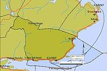
 Vadsø within Finnmark | |||||
| Coordinates: 70°04′24″N 29°44′59″E / 70.07333°N 29.74972°ECoordinates: 70°04′24″N 29°44′59″E / 70.07333°N 29.74972°E | |||||
| Country | Norway | ||||
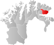
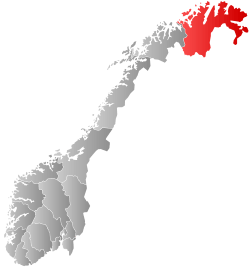
| County | Finnmark | ||||
| District | Øst-Finnmark | ||||
| Established | 1 Jan 1838 | ||||
| Administrative centre | Vadsø | ||||
| Government | |||||
| • Mayor (2015) | Hans-Jacob Bønå (H) | ||||
| Area | |||||
| • Total | 1,257.84 km2 (485.65 sq mi) | ||||
| • Land | 1,233.68 km2 (476.33 sq mi) | ||||
| • Water | 24.16 km2 (9.33 sq mi) 1.9% | ||||
| Area rank | #77 in Norway | ||||
| Population (2017) | |||||
| • Total |
6,154 ( | ||||
| • Rank | #169 in Norway | ||||
| • Density | 5.0/km2 (13/sq mi) | ||||
| • Change (10 years) | 0.5% | ||||
| Demonym(s) | Vadsøværing[1] | ||||
| Time zone | UTC+01:00 (CET) | ||||
| • Summer (DST) | UTC+02:00 (CEST) | ||||
| ISO 3166 code | NO-2003 | ||||
| Official language form | Bokmål | ||||
| Website |
vadso | ||||

Vadsø [²vɑdsøː] (![]()
The 1,258-square-kilometre (486 sq mi) municipality is the 77th largest by area out of the 422 municipalities in Norway. Vadsø is the 169th most populous municipality in Norway with a population of 6,154. The municipality's population density is 5 inhabitants per square kilometre (13/sq mi) and its population has increased by 0.5% over the last decade.[2]
General information
The village of Vadsø was granted town status in 1833. In 1838, the town of Vadsø and the entire rural district surrounding the Varangerfjorden were established as the new municipality of Vadsø (see formannskapsdistrikt). The law required that all towns should be separated from their rural districts, but because of a low population and very few voters, this was impossible to carry out for the municipality of Vadsø in 1838. (This was also true in the towns of Hammerfest and Vardø.)
In 1839, the western district (population: 598) was separated to become the new municipality of Nesseby. This left Vadsø with 388 residents. In 1858, Vadsø municipality changed again: Nesseby Municipality (population: 706) was merged back into Vadsø and the district of Vadsø located south of the Varangerfjorden (population: 1,171) was separated to form the new municipality of Sør-Varanger. This change resulted in a population of 2,050 in Vadsø municipality. In 1864, the western district of Nesseby (population: 866) was separated into a separate municipality once again, leaving Vadsø with 1,367 residents.
On 1 January 1894, the rest of the rural district (population: 1,296) surrounding the town of Vadsø was separated to form the new municipality of Nord-Varanger. This left just the town of Vadsø remaining in the municipality of Vadsø which now had 1,114 residents. During the 1960s, there were many municipal mergers across Norway due to the work of the Schei Committee. On 1 January 1964, the municipality of Nord-Varanger (population: 1,587) was merged with the town of Vadsø (population: 3,353) to form the present-day Vadsø Municipality.[3]
Name
The municipality is named after the town of Vadsø. The name of the town comes from the island Vadsøya, since that was the original townsite. The Old Norse form of the name was Vatnsøy. The first element is the genitive case of vatn which means "water" and the last element is øy which means "island". Therefore, the meaning of the name is "the island with drinking water".[4]
Coat of arms
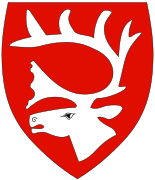
The coat of arms is from modern times; they were granted on 20 February 1976. The arms show the head of a reindeer stag in silver on a red background. The reindeer is the main domestic animal in the municipality and thus of great economic importance.[5] [6]
Churches
The Church of Norway has one parish (sokn) within the municipality of Vadsø. It is part of the Varanger prosti (deanery) in the Diocese of Nord-Hålogaland.
| Parish (sokn) | Name | Location | Year built |
|---|---|---|---|
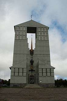
| Vadsø | Vadsø Church | Vadsø | 1958 |
| Vestre Jakobselv Church | Vestre Jakobselv | 1940 | |
| Skallelv Chapel | Skallelv | 1961 |
History
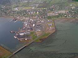
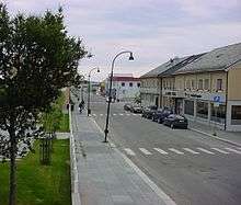
In the 16th century, the settlement of Vadsø consisted of a fishing village and the old Vadsø Church, located on the island of Vadsøya. The settlement later moved to the mainland. Pomor trade led Vadsø to be a major trading centre in this part of Norway. Township privilege was granted in 1833, and soon settlers came from Finland and the northern part of Sweden, which suffered from famine.
Finnish was rapidly becoming the language of the majority, and this continued for decades. As of 2016, Finnish is still spoken in some households. During the occupation of Norway by Nazi Germany, Vadsø suffered several air raids from the Soviet Union, which bombed German troops. However, there are, unlike most places in Finnmark, a number of 19th century wooden houses preserved close to the city centre, notably the house of Esbensen, built by a Norwegian, and the house of Tuomainen, built by a Finn. On the island of Vadsøya is the airship mast used by Umberto Nobile and Roald Amundsen for their expedition over the North Pole with the airship Norge in 1926, and used again on Nobile's flight with the airship Italia in 1928.[4]
Government
All municipalities in Norway, including Vadsø, are responsible for primary education (through 10th grade), outpatient health services, senior citizen services, unemployment and other social services, zoning, economic development, and municipal roads. The municipality is governed by a municipal council of elected representatives, which in turn elect a mayor.[7] The municipality falls under the Øst-Finnmark District Court and the Hålogaland Court of Appeal.
Municipal council
The municipal council (Kommunestyre) of Vadsø is made up of 25 representatives that are elected to four year terms. Currently, the party breakdown is as follows:[8]
| Party Name | Name in Norwegian | Number of representatives | |
|---|---|---|---|
| Labour Party | Arbeiderpartiet | 8 | |
| Conservative Party | Høyre | 10 | |
| Christian Democratic Party | Kristelig Folkeparti | 1 | |
| Green Party | Miljøpartiet De Grønne | 1 | |
| Socialist Left Party | Sosialistisk Venstreparti | 3 | |
| Local Lists | Lokale lister | 2 | |
| Total number of members: | 25 | ||
Geography
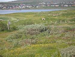
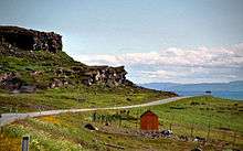
The municipality of Vadsø forms the southern coast of the Varanger Peninsula, which is largely covered by birch forests on this more sheltered side (as opposed to the northern side). The Varangerfjorden flows along the southern coast of the municipality and the river Jakobselva runs along the western border of Vadsø. The small islands of Lille Ekkerøy and Vadsøya lie in the Varangerfjorden. The Varangerhalvøya National Park lies in a large part of the interior parts of the municipality.[4] The "midnight sun" is above the horizon from 17 May to 28 July (73 days), and the period with continuous daylight lasts a bit longer, polar night from 25 November to 17 January (54 days).
Climate
| Climate data for Ekkerøy | |||||||||||||
|---|---|---|---|---|---|---|---|---|---|---|---|---|---|
| Month | Jan | Feb | Mar | Apr | May | Jun | Jul | Aug | Sep | Oct | Nov | Dec | Year |
| Daily mean °C (°F) | −6.4 (20.5) |
−6.8 (19.8) |
−4.5 (23.9) |
−1.3 (29.7) |
3.1 (37.6) |
7.4 (45.3) |
10.7 (51.3) |
10.0 (50) |
6.7 (44.1) |
1.9 (35.4) |
−2.0 (28.4) |
−4.9 (23.2) |
1.2 (34.2) |
| Average precipitation mm (inches) | 48 (1.89) |
39 (1.54) |
39 (1.54) |
41 (1.61) |
31 (1.22) |
41 (1.61) |
53 (2.09) |
55 (2.17) |
52 (2.05) |
53 (2.09) |
53 (2.09) |
45 (1.77) |
550 (21.65) |
| Source: Norwegian Meteorological Institute[9] | |||||||||||||
Wildlife
Birdlife
Situated on the shores of the Varangerfjorden the municipality of Vadsø is known for its interesting birdlife. Many of its coastal localities like Store Ekkerøy are internationally known for its rich and interesting birdlife. The harbor at Vadsø can produce all three species of eider, including the small and stunning Steller's eider.
Commerce
River fishing
Fishing permits (for salmon fishing) are sold for use on specific rivers, including Komag-elva.[10]
Transportation
Vadsø Airport is located in Kiby, just to the east of the town. The town is also a port of call for the Hurtigruten coastal express boats. Vadsø is located along the European route E75 highway.[4]
Notable residents
- Norwegian footballers Morten Gamst Pedersen and Sigurd Rushfeldt both grew up in Vadsø.
- Lars Bohinen (Rushfeldt's cousin), who is also a former footballer, was born in the town, but his family moved south when he was a child.
- Stig Henrik Hoff, actor, war born in Vadsø.
International relations
Twin towns — Sister cities
Vadsø is twinned with the following cities:
References
- ↑ "Navn på steder og personer: Innbyggjarnamn" (in Norwegian). Språkrådet. Retrieved 2015-12-01.
- ↑ Statistisk sentralbyrå (2017). "Table: 06913: Population 1 January and population changes during the calendar year (M)" (in Norwegian). Retrieved 2017-09-09.
- ↑ Jukvam, Dag (1999). "Historisk oversikt over endringer i kommune- og fylkesinndelingen" (PDF) (in Norwegian). Statistisk sentralbyrå. Retrieved 12 September 2016.
- 1 2 3 4 Thorsnæs, Geir; Askheim, Svein, eds. (2018-01-10). "Vadsø". Store norske leksikon (in Norwegian). Kunnskapsforlaget. Retrieved 2018-05-29.
- ↑ "Civic heraldry of Norway - Norske Kommunevåpen". Heraldry of the World. Retrieved 2018-05-28.
- ↑ "Kommunevåpen". Flags of the World. 28 June 2002. Retrieved 13 December 2008.
- ↑ Hansen, Tore, ed. (2016-05-12). "kommunestyre". Store norske leksikon (in Norwegian). Kunnskapsforlaget. Retrieved 2018-05-28.
- ↑ "Table: 04813: Members of the local councils, by party/electoral list at the Municipal Council election (M)" (in Norwegian). Statistics Norway. 2015.
- ↑ "eKlima Web Portal". Norwegian Meteorological Institute. Archived from the original on 2004-06-14.
- ↑ "Laksefiske for alle". Aftenposten. 19 July 2014. p. 11.
External links
| Wikimedia Commons has media related to Vadsø. |
- Municipal fact sheet from Statistics Norway (in Norwegian)
- Varanger.com: tourist information about Varanger area
- List of town twinnings in Scandinavia (in Norwegian)
| |||||||||||
| Authority control |
|---|