Gamvik
| Gamvik kommune Gáŋgaviikka gielda | |||||
|---|---|---|---|---|---|
| Municipality | |||||
 View of Mehamn on new year's day (during the polar night) | |||||
| |||||
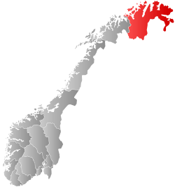
 Gamvik within Finnmark | |||||
| Coordinates: 71°02′28″N 27°51′05″E / 71.04111°N 27.85139°ECoordinates: 71°02′28″N 27°51′05″E / 71.04111°N 27.85139°E | |||||
| Country | Norway | ||||
| County | Finnmark | ||||
| District | Øst-Finnmark | ||||
| Established | 1 Jan 1914 | ||||
| Administrative centre | Mehamn | ||||
| Government | |||||
| • Mayor (2015) | Trond Einar Olaussen (Ap) | ||||
| Area | |||||
| • Total | 1,416.34 km2 (546.85 sq mi) | ||||
| • Land | 1,354.87 km2 (523.12 sq mi) | ||||
| • Water | 61.47 km2 (23.73 sq mi) 4.3% | ||||
| Area rank | #60 in Norway | ||||
| Population (2017) | |||||
| • Total |
1,137 ( | ||||
| • Rank | #383 in Norway | ||||
| • Density | 0.8/km2 (2/sq mi) | ||||
| • Change (10 years) | 8.7% | ||||
| Demonym(s) |
Gamviking or Gamvikværing[1] | ||||
| Time zone | UTC+01:00 (CET) | ||||
| • Summer (DST) | UTC+02:00 (CEST) | ||||
| ISO 3166 code | NO-2023 | ||||
| Official language form | Neutral | ||||
| Website |
gamvik | ||||


![]()
Most people live in the village of Mehamn (about 500 inhabitants), which has an airport, Mehamn Airport, and is also a port of call of the hurtigruten coastal boats. The Slettnes Lighthouse near the village of Gamvik is the northernmost lighthouse on the mainland of Europe. Nervei and Langfjordbotn are two very small villages in southern Gamvik that are only accessible by boat. Finnkongkeila is an abandoned village along the Tanafjorden.
The 1,416-square-kilometre (547 sq mi) municipality is the 60th largest by area out of the 422 municipalities in Norway. Gamvik is the 383rd most populous municipality in Norway with a population of 1,137. The municipality's population density is 0.8 inhabitants per square kilometre (2.1/sq mi) and its population has increased by 8.7% over the last decade.[2]
General information


The municipality of Gamvik was established on 1 January 1914 when the old Tana Municipality was divided into three municipalities: Tana (population: 1,426) in the south, Berlevåg (population: 784) in the northeast, and Gamvik (population: 1,371) in the northwest. The municipal boundaries have not changed since that time.[3]
Name
The Old Norse form of the name may have been Gangvík. The first element is then gangr which means "path" and the last element is vík which means "cove" or "wick".[4]
Coat of arms
The coat of arms is from modern times. They were granted on 28 September 1990. The arms show three gold/yellow fishing net sewing needles set diagonally on a red background. These needles are a characteristic maritime tool used for making and mending the fishing nets used by local fishermen. These arms were chosen to emphasize the importance of fishing in the area.[5]
Churches
The Church of Norway has one parish (sokn) within the municipality of Gamvik. It is part of the Hammerfest prosti (deanery) in the Diocese of Nord-Hålogaland.
| Parish (Sokn) | Church Name | Location of the Church | Year Built |
|---|---|---|---|
| Gamvik | Gamvik Church | Gamvik | 1958 |
| Hop Church | Skjånes | 1977 | |
| Mehamn Chapel | Mehamn | 1965 |
History
In June 1972 construction started for [a landside terminal and] running a SOSUS cable into the sea.[6] The SOSUS station was one of more than twenty worldwide.[6]
1982 air crash
On 12 March 1982, a Widerøe Twin Otter, registration number LN-BNK, crashed into the sea near Mehamn, killing all fifteen on board. More than twenty years and four rounds of investigation later, this incident remains highly controversial in Norway.
Government
All municipalities in Norway, including Gamvik, are responsible for primary education (through 10th grade), outpatient health services, senior citizen services, unemployment and other social services, zoning, economic development, and municipal roads. The municipality is governed by a municipal council of elected representatives, which in turn elect a mayor.[7] The municipality falls under the Øst-Finnmark District Court and the Hålogaland Court of Appeal.
Municipal council
The municipal council (Kommunestyre) of Gamvik is made up of 13 representatives that are elected to four year terms. Currently, the party breakdown is as follows:[8]
| Party Name | Name in Norwegian | Number of representatives | |
|---|---|---|---|
| Labour Party | Arbeiderpartiet | 7 | |
| Progress Party | Fremskrittspartiet | 2 | |
| Socialist Left Party | Sosialistisk Venstreparti | 4 | |
| Total number of members: | 13 | ||
Geography
The municipality consists of the eastern half of the Nordkinn Peninsula. Kinnarodden, located in Gamvik, is the northernmost point of mainland Europe (the more well-known North Cape is located nearby on Magerøya island). The Tanafjorden flows along the eastern coast of Gamvik. Lebesby Municipality is located to the west and Tana Municipality is located to the south. Across the fjord to the east is Berlevåg Municipality.
Climate
| Climate data for Slettnes Lighthouse | |||||||||||||
|---|---|---|---|---|---|---|---|---|---|---|---|---|---|
| Month | Jan | Feb | Mar | Apr | May | Jun | Jul | Aug | Sep | Oct | Nov | Dec | Year |
| Average high °C (°F) | −1.9 (28.6) |
−2.0 (28.4) |
−1.1 (30) |
1.0 (33.8) |
4.7 (40.5) |
8.7 (47.7) |
11.9 (53.4) |
11.3 (52.3) |
8.7 (47.7) |
4.3 (39.7) |
1.2 (34.2) |
−0.8 (30.6) |
3.8 (38.8) |
| Daily mean °C (°F) | −4.4 (24.1) |
−4.5 (23.9) |
−3.1 (26.4) |
−0.8 (30.6) |
2.8 (37) |
6.3 (43.3) |
9.3 (48.7) |
9.2 (48.6) |
6.7 (44.1) |
2.5 (36.5) |
−0.9 (30.4) |
−3.2 (26.2) |
1.7 (35.1) |
| Average low °C (°F) | −7.3 (18.9) |
−7.4 (18.7) |
−5.8 (21.6) |
−3.2 (26.2) |
0.8 (33.4) |
4.3 (39.7) |
7.3 (45.1) |
7.2 (45) |
4.7 (40.5) |
0.3 (32.5) |
−3.4 (25.9) |
−5.9 (21.4) |
−0.7 (30.7) |
| Average precipitation mm (inches) | 47 (1.85) |
37 (1.46) |
35 (1.38) |
34 (1.34) |
36 (1.42) |
37 (1.46) |
45 (1.77) |
46 (1.81) |
53 (2.09) |
67 (2.64) |
56 (2.2) |
46 (1.81) |
539 (21.22) |
| Average precipitation days (≥ 1 mm) | 13.2 | 10.7 | 10.5 | 10.0 | 9.5 | 9.4 | 9.1 | 10.4 | 13.4 | 15.7 | 14.4 | 13.8 | 140.1 |
| Source: Norwegian Meteorological Institute[9] | |||||||||||||
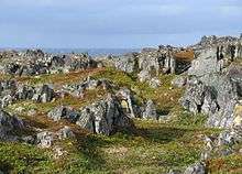
Birdlife
The area surrounding the lighthouse at Slettnes is also an interesting locality for those interested in birds and birdwatching. There is a nature reserve and bird observatory.
Notable people
- Tor Henriksen (1933–2017), politician for the Socialist Left Party
- Ragnhild Vassvik Kalstad (b. 1966), politician for the Labour Party
- Torgeir Vassvik (b. 1963), Sami musician and composer
References
- ↑ "Navn på steder og personer: Innbyggjarnamn" (in Norwegian). Språkrådet. Retrieved 2015-12-01.
- ↑ Statistisk sentralbyrå (2017). "Table: 06913: Population 1 January and population changes during the calendar year (M)" (in Norwegian). Retrieved 2017-09-09.
- ↑ Jukvam, Dag (1999). "Historisk oversikt over endringer i kommune- og fylkesinndelingen" (PDF) (in Norwegian). Statistisk sentralbyrå.
- ↑ Rygh, Oluf (1924). Norske gaardnavne: Finmarkens amt (in Norwegian) (18 ed.). Kristiania, Norge: W. C. Fabritius & sønners bogtrikkeri. p. 237.
- ↑ "Civic heraldry of Norway - Norske Kommunevåpen". Heraldry of the World. Retrieved 2017-08-20.
- 1 2 https://www.nrk.no/dokumentar/xl/hemmelige-rom-ii_-episode-2-1.12703387
- ↑ Hansen, Tore, ed. (2016-05-12). "kommunestyre". Store norske leksikon (in Norwegian). Kunnskapsforlaget. Retrieved 2018-06-05.
- ↑ "Table: 04813: Members of the local councils, by party/electoral list at the Municipal Council election (M)" (in Norwegian). Statistics Norway. 2015.
- ↑ "eKlima Web Portal". Norwegian Meteorological Institute. Archived from the original on 2004-06-14.
External links
| Wikimedia Commons has media related to Gamvik. |
- Official website
- Municipal fact sheet from Statistics Norway (in Norwegian)
- Mehamnulykken -- NRK's collection of articles about the 1982 air crash. (in Norwegian)
- Mehamn.net: live webcam at Mehamn
- Nordic Safari Wildlife Adventures: Mehamn
- Gamvik Museum
| |||||||||||
| Authority control |
|---|