Vardø (town)
| Vardø Vuorea (Kven) Várggát (Northern Sami) | |
|---|---|
| Town | |
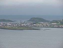 View of the town from the mainland | |
 Vardø Location in Finnmark  Vardø Vardø (Norway) | |
| Coordinates: 70°22′13″N 31°06′38″E / 70.37028°N 31.11056°ECoordinates: 70°22′13″N 31°06′38″E / 70.37028°N 31.11056°E | |
| Country | Norway |
| Region | Northern Norway |
| County | Finnmark |
| District | Øst-Finnmark |
| Municipality | Vardø Municipality |
| Area[1] | |
| • Total | 1.19 km2 (0.46 sq mi) |
| Elevation[2] | 9 m (30 ft) |
| Population (2017)[1] | |
| • Total | 1,875 |
| • Density | 1,576/km2 (4,080/sq mi) |
| Time zone | UTC+01:00 (CET) |
| • Summer (DST) | UTC+02:00 (CEST) |
| Post Code | 9950 Vardø |
![]()
Vardø is the easternmost town in Norway (and in all the Nordic countries), located at 31°E, which is east of Saint Petersburg, Kiev, and Istanbul. The eastern part of Finnmark is in the same time zone as the rest of the country, but it is more than an hour at odds with daylight hours.
The largest industry in the town is fishing and fish processing. There is a good port in Vardø, and another port in nearby Svartnes, on the mainland. The town is connected to the mainland by the undersea Vardø Tunnel which is part of European route E75. Vardø Airport, Svartnes is located at the other end of the tunnel on the mainland.
History
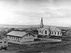
The village of Vardø, on the island of Vardøya, was made important because of the Vardøhus Fortress that was built on the island in the early 14th century. The village grew up around the fortress and became a major trading post between the Norwegians in Finnmark county and the nearby Russians. In the 17th century, Vardø was a centre of several high-profile witch trials, most notably the 1621 witch trial and 1662 witch trials.[3]
Pomor trade was very important in the 18th century, and Vardø was often called the Pomor capital. Because of this, in 1789 the King of Norway granted Vardø town status.[3][4]
On 1 January 1838, the town and the surrounding rural district were established as the new municipality of Vardø by og landdistrikt, meaning "Vardø town and rural district" (see Formannskapsdistrikt). This arrangement did not entirely satisfy the new formannskapsdistrikt law, so in 1839, the town was separated from the rural district to form its own town-municipality. Since the Vardø landdistrikt outside the town had too few residents (according to the law), one municipal government was shared between the two until 22 May 1868 when a royal resolution was passed making them completely separate and self-governing. On 1 January 1874, a small area of Vardø landdistrikt (population: 48) was transferred to the town of Vardø. On 1 January 1964, the eastern part of Båtsfjord (population: 621) was merged with the town of Vardø, forming the new (present-day) Vardø Municipality.[5]
Name
The town is named after the island on which it is located: Vardøya. The Old Norse form of the name was Vargøy. The first element is vargr which means "wolf" and the last element is øy which means "island". The first element was later replaced (around 1500) with varða which means "cairn".[3][6]
Climate
The prevailing climate is called a tundra climate. Even in the warmest month of the year the temperatures are very low. The climate here is classified as ET by the Köppen-Geiger system. The average annual temperature in Vardø is 1.5 °C. In a year, the average rainfall is 549 mm.
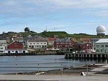
Globus Radar
Since 1998, the town has housed a radar installation called Globus II. Its official purpose is the tracking of space junk; however, due to the site's proximity to Russia, and an alleged connection between the Globus II system and US anti-missile systems, the site has been the basis for heated controversy in diplomatic and intelligence circles.[7]
Globus 3
An upgrade to the radar system is under construction on the island.[8][9] The Russian military considers the radar station a threat to its national security.[9]
See also
References
| Wikimedia Commons has media related to Vardø. |
- 1 2 3 Statistisk sentralbyrå (1 January 2017). "Urban settlements. Population and area, by municipality".
- ↑ "Vardø" (in Norwegian). yr.no. Retrieved 2013-03-02.
- 1 2 3 Store norske leksikon. "Vardø" (in Norwegian). Retrieved 2013-03-02.
- ↑ "Vardø" (in Norwegian). Vardø kommune. Retrieved 2013-03-02.
- ↑ Jukvam, Dag (1999). "Historisk oversikt over endringer i kommune- og fylkesinndelingen" (PDF) (in Norwegian). Statistisk sentralbyrå.
- ↑ Rygh, Oluf (1924). Norske gaardnavne: Finmarkens amt (in Norwegian) (18 ed.). Kristiania, Norge: W. C. Fabritius & sønners bogtrikkeri. p. 301.
- ↑ "Antimissile Front In The Northern Norway".
- ↑ "Modernisering av radaranlegget i Vardø" (in Norwegian). Norwegian Armed Forces. April 6, 2016. Archived from the original on June 14, 2017.
- 1 2 Higgins, Andrew (June 13, 2017). "On a Tiny Norwegian Island, America Keeps an Eye on Russia". The New York Times. Retrieved June 14, 2017.