Nordkapp
| Nordkapp kommune Davvinjárgga gielda Kappan komuuni | |||||
|---|---|---|---|---|---|
| Municipality | |||||
 Honningsvåg harbour | |||||
| |||||
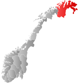
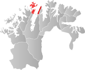 Nordkapp within Finnmark | |||||
| Coordinates: 70°58′41″N 25°58′29″E / 70.97806°N 25.97472°ECoordinates: 70°58′41″N 25°58′29″E / 70.97806°N 25.97472°E | |||||
| Country | Norway | ||||
| County | Finnmark | ||||
| District | Vest-Finnmark | ||||
| Established | 1 July 1861 | ||||
| Administrative centre | Honningsvåg | ||||
| Government | |||||
| • Mayor (2007) | Kristina Hansen (Ap) | ||||
| Area | |||||
| • Total | 925.70 km2 (357.41 sq mi) | ||||
| • Land | 891.60 km2 (344.25 sq mi) | ||||
| • Water | 34.10 km2 (13.17 sq mi) 3.7% | ||||
| Area rank | #120 in Norway | ||||
| Population (2017) | |||||
| • Total |
3,291 ( | ||||
| • Rank | #252 in Norway | ||||
| • Density | 3.7/km2 (10/sq mi) | ||||
| • Change (10 years) | 0.5% | ||||
| Demonym(s) | Nordkappværing[1] | ||||
| Time zone | UTC+01:00 (CET) | ||||
| • Summer (DST) | UTC+02:00 (CEST) | ||||
| ISO 3166 code | NO-2019 | ||||
| Official language form | Neutral | ||||
| Website |
nordkapp | ||||

Nordkapp (English: North Cape; Northern Sami: Davvinjárga or Nordkáhppa; Kven: Kappa or Nordkappa) is a municipality in Finnmark county, Norway. The administrative centre of the municipality is the town of Honningsvåg, where most residents live. Other settlements in Nordkapp include the villages of Gjesvær, Kåfjord, Kamøyvær, Kjelvik, Nordvågen, Repvåg, Skarsvåg, and Valan.[2]
The 926-square-kilometre (358 sq mi) municipality is the 120th largest by area out of the 422 municipalities in Norway. Nordkapp is the 252nd most populous municipality in Norway with a population of 3,291. The municipality's population density is 3.7 inhabitants per square kilometre (9.6/sq mi) and its population has increased by 0.5% over the last decade.[3]
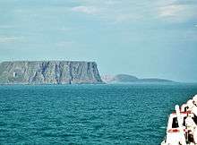
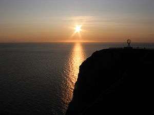
Some 200,000 tourists visit Nordkapp annually during the two to three months of summer. The main tourist attractions are the North Cape and the nearby Knivskjellodden. The North Cape first became famous when the English explorer Richard Chancellor rounded it in 1553 while attempting to find a sea route through the Northeast Passage. Helnes Lighthouse is located at the entrance to the Porsangerfjorden.[2]
General information
On 1 July 1861, the northern district of the municipality of Kistrand was separated to form the new municipality of Kjelvik. Initially, the municipality encompassed the land on both sides of the northern end of the Porsangerfjorden, including the eastern part of the island of Magerøya, and it had a population of 345. The name of the municipality was changed from Kjelvik to Nordkapp in 1950. On 1 January 1984, the western part of the island of Magerøya as well as the small surrounding islands of Gjesværstappan (population: 240) were transferred from Måsøy Municipality to Nordkapp Municipality.[4]
Name
Nordkapp is a Norwegianized form of the English name North Cape by which the area was historically known dating back to at least 1553. The Old Norse name of the cape was Knyskanes. The municipality was originally named Kjelvik, after the main fishing village for the parish. But that village was totally destroyed by the Germans in 1944 and it was never rebuilt. As a consequence of this the municipality changed the name to Nordkapp in 1950.[2]
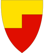
Coat of arms
The coat of arms is modern, having been granted on 19 October 1973. The red and gold arms show a simplified silhouette of the North Cape, a large cliff, together with the sea under a golden sky representing the midnight sun.[5]
Churches
The Church of Norway has one parish (sokn) within the municipality of Nordkapp. It is part of the Hammerfest prosti (deanery) in the Diocese of Nord-Hålogaland.
| Parish (sokn) | Name | Location | Year built |
|---|---|---|---|
| Nordkapp | Gjesvær Chapel | Gjesvær | 1960 |
| Honningsvåg Church | Honningsvåg | 1885 | |
| Repvåg Chapel | Repvåg | 1967 | |
| Skarsvåg Church | Skarsvåg | 1961 |
Government
All municipalities in Norway, including Nordkapp, are responsible for primary education (through 10th grade), outpatient health services, senior citizen services, unemployment and other social services, zoning, economic development, and municipal roads. The municipality is governed by a municipal council of elected representatives, which in turn elect a mayor.[6] The municipality falls under the Hammerfest District Court and the Hålogaland Court of Appeal.
Municipal council
The municipal council (Kommunestyre) of Nordkapp is made up of 19 representatives that are elected to four year terms. Currently, the party breakdown is as follows:[7]
| Party Name | Name in Norwegian | Number of representatives | |
|---|---|---|---|
| Labour Party | Arbeiderpartiet | 10 | |
| Conservative Party | Høyre | 4 | |
| Socialist Left Party | Sosialistisk Venstreparti | 3 | |
| Liberal Party | Venstre | 2 | |
| Total number of members: | 19 | ||
Geography
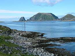
The municipality encompasses the island of Magerøya, but also parts of the mainland on the Porsanger Peninsula and Sværholt Peninsula on both sides of the Porsangerfjorden. There are many other fjords in the municipality including Duksfjorden, Kåfjorden, Kamøyfjorden, and Skipsfjorden. The main island is Magerøya and there are a few islands located around Magerøya including Gjesvær, Gjesværstappan, Lille Kamøya, and Store Kamøya.[2]
North Cape
The municipality is named after Nordkapp (North Cape), a 307-metre-high (1,007 ft) cliff that is commonly referred to as the northernmost point of Europe. However, the true northernmost point of the European mainland is Cape Nordkinn (Kinnarodden), at 71° 08′ 02″ N, located about 20 kilometres (12 mi) from the village of Mehamn on the Nordkinn Peninsula. If Europe's northernmost point is allowed to be on an island, then it still is not the North Cape. It would be Cape Fligely on Rudolf Island, Franz Josef Land in Russia, which is located much further north at 81° 48′ 24″ N. If Franz Josef Land is not considered to be in Europe, then Europe's northernmost point is the northern point of the island of Rossøya, an islet in Svalbard, north of Spitsbergen at 80° 49′ 44.41″ N.
Birdlife
This coastal municipality is like many others in Finnmark, home of large seabird colonies. The island group known as Gjesværstappan is one of the better known with at least 2,500 pairs of razorbill. Away from the coast it is the typical tundra habitat of the region that dominates with lakes, marshes, and areas of willow scrub. Many of the lakes hold breeding wildfowl, with species like long-tailed duck being found.
Climate
| Climate data for Helnes Lighthouse | |||||||||||||
|---|---|---|---|---|---|---|---|---|---|---|---|---|---|
| Month | Jan | Feb | Mar | Apr | May | Jun | Jul | Aug | Sep | Oct | Nov | Dec | Year |
| Average high °C (°F) | −1.5 (29.3) |
−1.6 (29.1) |
−0.7 (30.7) |
1.4 (34.5) |
5.2 (41.4) |
9.3 (48.7) |
12.6 (54.7) |
11.8 (53.2) |
8.6 (47.5) |
4.5 (40.1) |
1.5 (34.7) |
−0.5 (31.1) |
4.2 (39.6) |
| Daily mean °C (°F) | −3.6 (25.5) |
−3.6 (25.5) |
−2.4 (27.7) |
−0.2 (31.6) |
3.4 (38.1) |
6.9 (44.4) |
10.1 (50.2) |
9.7 (49.5) |
6.9 (44.4) |
3.0 (37.4) |
−0.2 (31.6) |
−2.4 (27.7) |
2.3 (36.1) |
| Average low °C (°F) | −5.7 (21.7) |
−5.7 (21.7) |
−4.2 (24.4) |
−1.8 (28.8) |
1.6 (34.9) |
5.0 (41) |
8.0 (46.4) |
8.0 (46.4) |
5.4 (41.7) |
1.5 (34.7) |
−2.0 (28.4) |
−4.3 (24.3) |
0.5 (32.9) |
| Average precipitation mm (inches) | 94 (3.7) |
75 (2.95) |
67 (2.64) |
59 (2.32) |
42 (1.65) |
40 (1.57) |
44 (1.73) |
50 (1.97) |
59 (2.32) |
83 (3.27) |
82 (3.23) |
101 (3.98) |
796 (31.34) |
| Average precipitation days (≥ 1 mm) | 18.1 | 15.3 | 14.6 | 13.6 | 10.6 | 9.6 | 9.3 | 10.5 | 13.9 | 17.5 | 16.5 | 18.7 | 168.2 |
| Source: Norwegian Meteorological Institute[8] | |||||||||||||
Transportation
Due to the heavy tourist traffic in the summers, Nordkapp has an extensive transportation infrastructure for such a small, remote municipality. The Honningsvåg Airport, Valan is located just north of the town of Honningsvåg, with daily connections to Tromsø. The European route E69 highway runs north throughout the municipality from Porsanger to the North Cape. The North Cape Tunnel connects the mainland to the island of Magerøya. The Honningsvåg Tunnel goes through a large mountain near Honningsvåg.[2]
References
- ↑ "Navn på steder og personer: Innbyggjarnamn" (in Norwegian). Språkrådet. Retrieved 2015-12-01.
- 1 2 3 4 5 Store norske leksikon. "Nordkapp kommune" (in Norwegian). Retrieved 2013-02-18.
- ↑ Statistisk sentralbyrå (2017). "Table: 06913: Population 1 January and population changes during the calendar year (M)" (in Norwegian). Retrieved 2017-09-09.
- ↑ Jukvam, Dag (1999). "Historisk oversikt over endringer i kommune- og fylkesinndelingen" (PDF) (in Norwegian). Statistisk sentralbyrå.
- ↑ "Civic heraldry of Norway - Norske Kommunevåpen". Heraldry of the World. Retrieved 2017-08-20.
- ↑ Hansen, Tore, ed. (2016-05-12). "kommunestyre". Store norske leksikon (in Norwegian). Kunnskapsforlaget. Retrieved 2018-06-05.
- ↑ "Table: 04813: Members of the local councils, by party/electoral list at the Municipal Council election (M)" (in Norwegian). Statistics Norway. 2015.
- ↑ "eKlima Web Portal". Norwegian Meteorological Institute. Archived from the original on 2004-06-14.
External links
| Wikimedia Commons has media related to Nordkapp. |
| Wikivoyage has a travel guide for Nordkapp. |
- Municipal fact sheet from Statistics Norway (in Norwegian)
- Pictures from North Cape and Skarsvåg
- Motorbike travel from Italy to Nordkapp
- From Nordkapp to Italy by bike
- Nordkapp by rail
- 360x180° Panoramen from Nordkapp
- 6-day road trip from The Netherlands to the Nordkapp
| |||||||||||
| Authority control |
|---|