Måsøy
| Måsøy kommune Muosátsullo gielda Moseijan komuuni | |||||
|---|---|---|---|---|---|
| Municipality | |||||
 View of Havøysund in the winter | |||||
| |||||
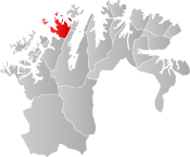 Måsøy within Finnmark | |||||
| Coordinates: 70°59′48″N 24°39′41″E / 70.99667°N 24.66139°ECoordinates: 70°59′48″N 24°39′41″E / 70.99667°N 24.66139°E | |||||
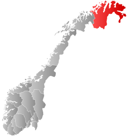
| Country | Norway | ||||
| County | Finnmark | ||||
| District | Vest-Finnmark | ||||
| Established | 1838 | ||||
| Administrative centre | Havøysund | ||||
| Government | |||||
| • Mayor (2017) | Reidun Helene Mortensen (Sp) | ||||
| Area | |||||
| • Total | 1,135.82 km2 (438.54 sq mi) | ||||
| • Land | 1,067.49 km2 (412.16 sq mi) | ||||
| • Water | 68.33 km2 (26.38 sq mi) 6% | ||||
| Area rank | #88 in Norway | ||||
| Population (2017) | |||||
| • Total |
1,204 ( | ||||
| • Rank | #379 in Norway | ||||
| • Density | 1.1/km2 (3/sq mi) | ||||
| • Change (10 years) | -8.7% | ||||
| Demonym(s) | Måsøying[1] | ||||
| Time zone | UTC+01:00 (CET) | ||||
| • Summer (DST) | UTC+02:00 (CEST) | ||||
| ISO 3166 code | NO-2018 | ||||
| Official language form | Bokmål | ||||
| Website |
masoy | ||||


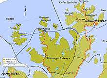
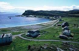
Måsøy (Northern Sami: Muosát; Kven: Moseija) is a municipality in Finnmark county, Norway. The administrative centre of the municipality is the village of Havøysund. Other villages include Ingøy, Måsøy, Slåtten, and Gunnarnes. The municipality is located on the mainland as well as several islands.
The 1,136-square-kilometre (439 sq mi) municipality is the 88th largest by area out of the 422 municipalities in Norway. Masøy is the 379th most populous municipality in Norway with a population of 1,204. The municipality's population density is 1.1 inhabitants per square kilometre (2.8/sq mi) and its population has decreased by 8.7% over the last decade.[2]
The municipality includes the Fruholmen Lighthouse, the northernmost lighthouse in Norway as well as the Havøysund Bridge, the northernmost bridge in the world. The tallest tower in Scandinavia, the 362-meter (1,188 ft) tall Ingøy radio transmitter is located on Ingøya island.
The Hurtigruten coastal express boat stops at the village of Havøysund daily. There is also a road connection to Måsøy, albeit often blocked by snow in the winter. Norwegian County Road 889 connects the mainland to Havøysund.
General information
The town of Hammerfest and the vast surrounding rural district of Hammerfest was established as the municipality of Hammerfest by og landdistrikt on 1 January 1838 (see formannskapsdistrikt). Soon after (the same year), the northern district (population: 498) was separated to become the new municipality of Maasøe, named after the village on the island of Måsøya where the local church is located. The spelling was later changed to Måsøy.
On 1 January 1963, a small area of southern Måsøy, north of Kokelv, (population: 34) was transferred to neighboring Kvalsund Municipality. On 1 January 1984, the western part of the island of Magerøya (population: 240) was transferred from Måsøy to the neighboring Nordkapp Municipality.[3]
Name
The first element is måse which means "seagull" and the last element is øy which means "island". Previously, the village of Måsøy was the administratice centre since the main Måsøy Church was located there, hence it became the name of the municipality. Prior to 1918, the name was written Maasøe or Maasø.[4]
Coat of arms
The coat of arms is from modern times; they were granted on 7 September 1984. The arms show a golden-yellow fishing gaff on a red background. These fishing gaffs have been used for many centuries in the municipality to haul large fish into the boat. The device is made of a large piece of wood with a bone or metal hook. The tool was chosen as a symbol for the importance of fishing to the municipality.[5]
Churches
The Church of Norway has one parish (sokn) within the municipality of Måsøy. It is part of the Hammerfest prosti (deanery) in the Diocese of Nord-Hålogaland.
| Parish (sokn) | Church name | Location | Year built |
|---|---|---|---|
| Måsøy | Gunnarnes Chapel | Rolvsøya | 1986 |
| Havøysund Church | Havøysund | 1961 | |
| Ingøy Church | Ingøy | 1957 | |
| Måsøy Church | Måsøya | 1953 | |
| Slotten Chapel | Slåtten | 1963 |
Government
All municipalities in Norway, including Måsøy, are responsible for primary education (through 10th grade), outpatient health services, senior citizen services, unemployment and other social services, zoning, economic development, and municipal roads. The municipality is governed by a municipal council of elected representatives, which in turn elect a mayor.[6] The municipality falls under the Hammerfest District Court and the Hålogaland Court of Appeal.
Municipal council
The municipal council (Kommunestyre) of Måsøy is made up of 15 representatives that are elected to four year terms. Currently, the party breakdown is as follows:[7]
| Party Name | Name in Norwegian | Number of representatives | |
|---|---|---|---|
| Labour Party | Arbeiderpartiet | 6 | |
| Conservative Party | Høyre | 2 | |
| Centre Party | Senterpartiet | 7 | |
| Total number of members: | 15 | ||
Geography
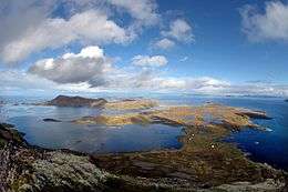
The municipality is located on the northern coast of western Finnmark, comprising parts of the mainland (located on the Porsanger Peninsula) and many islands of various sizes. The main islands include Måsøya, Hjelmsøya, Havøya, Ingøya, and Rolvsøya. Most people live in the village of Havøysund, but there are also small hamlets spread around the islands and in the fjord areas, notably Snefjord, Slåtten, Ingøy, Gunnarnes, and Måsøy. The large lake Havvatnet lies in the southern part of the municipality.
Birdlife
Lying in the northwest part of the county, Måsøy has a selection of habitats and a varied birdlife. Once again, some of the county's largest seabird colonies can be found in the municipality with the island of Hjelmsøya being one of the more interesting. White-tailed eagles can be seen as well as both Arctic skuas and great skuas.
Climate
| Climate data for Ingøya | |||||||||||||
|---|---|---|---|---|---|---|---|---|---|---|---|---|---|
| Month | Jan | Feb | Mar | Apr | May | Jun | Jul | Aug | Sep | Oct | Nov | Dec | Year |
| Average high °C (°F) | −0.4 (31.3) |
−0.4 (31.3) |
0.2 (32.4) |
1.9 (35.4) |
5.3 (41.5) |
8.9 (48) |
12.0 (53.6) |
11.7 (53.1) |
8.8 (47.8) |
5.2 (41.4) |
2.3 (36.1) |
0.5 (32.9) |
4.7 (40.5) |
| Daily mean °C (°F) | −2.4 (27.7) |
−2.4 (27.7) |
−1.5 (29.3) |
0.4 (32.7) |
3.6 (38.5) |
6.7 (44.1) |
9.7 (49.5) |
9.7 (49.5) |
7.2 (45) |
3.6 (38.5) |
0.6 (33.1) |
−1.4 (29.5) |
2.8 (37) |
| Average low °C (°F) | −4.4 (24.1) |
−4.4 (24.1) |
−3.2 (26.2) |
−1.3 (29.7) |
1.9 (35.4) |
5.0 (41) |
7.9 (46.2) |
8.1 (46.6) |
5.7 (42.3) |
2.1 (35.8) |
−1.1 (30) |
−3.3 (26.1) |
1.1 (34) |
| Average precipitation mm (inches) | 88 (3.46) |
74 (2.91) |
70 (2.76) |
61 (2.4) |
44 (1.73) |
46 (1.81) |
49 (1.93) |
52 (2.05) |
64 (2.52) |
89 (3.5) |
91 (3.58) |
102 (4.02) |
830 (32.68) |
| Average precipitation days (≥ 1 mm) | 17.9 | 15.6 | 15.8 | 14.5 | 11.3 | 10.5 | 10.0 | 11.0 | 14.6 | 19.2 | 18.0 | 19.4 | 177.8 |
| Source: Norwegian Meteorological Institute[8] | |||||||||||||
References
- ↑ "Navn på steder og personer: Innbyggjarnamn" (in Norwegian). Språkrådet. Retrieved 2015-12-01.
- ↑ Statistisk sentralbyrå (2017). "Table: 06913: Population 1 January and population changes during the calendar year (M)" (in Norwegian). Retrieved 2017-09-09.
- ↑ Jukvam, Dag (1999). "Historisk oversikt over endringer i kommune- og fylkesinndelingen" (PDF) (in Norwegian). Statistisk sentralbyrå.
- ↑ Rygh, Oluf (1924). Norske gaardnavne: Finmarkens amt (in Norwegian) (18 ed.). Kristiania, Norge: W. C. Fabritius & sønners bogtrikkeri. pp. 150–151.
- ↑ "Civic heraldry of Norway - Norske Kommunevåpen". Heraldry of the World. Retrieved 2017-08-20.
- ↑ Hansen, Tore, ed. (2016-05-12). "kommunestyre". Store norske leksikon (in Norwegian). Kunnskapsforlaget. Retrieved 2018-06-05.
- ↑ "Table: 04813: Members of the local councils, by party/electoral list at the Municipal Council election (M)" (in Norwegian). Statistics Norway. 2015.
- ↑ "eKlima Web Portal". Norwegian Meteorological Institute. Archived from the original on 2004-06-14.
External links

- Municipal fact sheet from Statistics Norway (in Norwegian)
| |||||||||||