Kvalsund
| Kvalsund kommune Fálesnuori gielda Valasnuoran komuuni | |||||
|---|---|---|---|---|---|
| Municipality | |||||
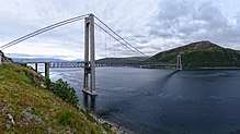
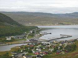 View of Ráhkkerávju | |||||
| |||||
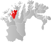 Kvalsund within Finnmark | |||||
| Coordinates: 70°29′56.3″N 23°58′26.2″E / 70.498972°N 23.973944°ECoordinates: 70°29′56.3″N 23°58′26.2″E / 70.498972°N 23.973944°E | |||||
| Country | Norway | ||||
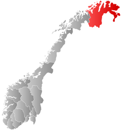
| County | Finnmark | ||||
| District | Vest-Finnmark | ||||
| Established | 1 July 1869 | ||||
| Administrative centre | Kvalsund | ||||
| Government | |||||
| • Mayor (2015) | Terje Wikstrøm (Ap) | ||||
| Area | |||||
| • Total | 1,844.29 km2 (712.08 sq mi) | ||||
| • Land | 1,739.35 km2 (671.57 sq mi) | ||||
| • Water | 104.94 km2 (40.52 sq mi) 5.7% | ||||
| Area rank | #37 in Norway | ||||
| Population (2017) | |||||
| • Total |
1,027 ( | ||||
| • Rank | #393 in Norway | ||||
| • Density | 0.6/km2 (2/sq mi) | ||||
| • Change (10 years) | -6% | ||||
| Demonym(s) | Kvalsundværing[1] | ||||
| Time zone | UTC+01:00 (CET) | ||||
| • Summer (DST) | UTC+02:00 (CEST) | ||||
| ISO 3166 code | NO-2017 | ||||
| Official language form | Bokmål | ||||
| Website |
kvalsund | ||||


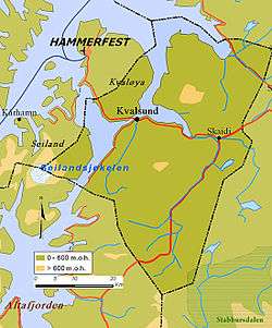
Kvalsund (Northern Sami: Fálesnuorri and Kven: Valasnuora) is a municipality in Finnmark county, Norway. The administrative centre of the municipality is the village of Kvalsund. Other villages in the municipality include Áisaroaivi, Kokelv, Oldernes, Oldervik, Revsneshamn, Skaidi.
The 1,844-square-kilometre (712 sq mi) municipality is the 37th largest by area out of the 422 municipalities in Norway. Kvalsund is the 393rd most populous municipality in Norway with a population of 1,027. The municipality's population density is 0.6 inhabitants per square kilometre (1.6/sq mi) and its population has decreased by 6% over the last decade.[2]
The Kvalsund Bridge (Kvalsundbrua) is a suspension bridge that crosses the Kvalsundet strait from the mainland to the island of Kvaløya.
In 2015, the media said that for four years an application has been filed for establishing Norway's largest copper mine, depending on a permit for creating a zone in Repparfjorden for depositing waste from the mine.[3]
General information
The municipality of Kvalsund was established on 1 July 1869 when it was separated from the Hammerfest landdistrikt (the rural municipality surrounding the town of Hammerfest). Initially, Kvalsund had 514 residents. On 1 January 1963, the Kokelv area in southern Måsøy Municipality (population: 34) was transferred to Kvalsund.[4]
In 2017, the two neighboring municipalities of Hammerfest and Kvalsund voted to merge into one large municipality effective 1 January 2020. The new municipality will be named Hammerfest and it's administrative centre will be the town of Hammerfest.[5]
Name
The Old Norse form of the name was Hvalsund. The first element is hvalr which means "whale" and the last element is sund which means "strait" or "sound". The Sámi name also translates to Whale (fáles) Strait (nuorri).[6]
Coat of arms
The coat of arms is from modern times; they were granted on 27 March 1987. The arms show three silver-colored salmon arranged in a pall on a blue background. The salmon represents fishing in various forms: as a traditional way of living and source of income, as modern fish farming, and as a recreational activity.[7]
Churches
The Church of Norway has two parishes (sokn) within the municipality of Kvalsund. It is part of the Hammerfest prosti (deanery) in the Diocese of Nord-Hålogaland.
| Parish (sokn) | Name | Location | Year built |
|---|---|---|---|
| Kvalsund | Kvalsund Church | Kvalsund | 1936 |
| Sennalandet Chapel | Áisaroaivi | 1961 | |
| Kokelv | Kokelv Church | Kokelv | 1960 |
Government
All municipalities in Norway, including Kvalsund, are responsible for primary education (through 10th grade), outpatient health services, senior citizen services, unemployment and other social services, zoning, economic development, and municipal roads. The municipality is governed by a municipal council of elected representatives, which in turn elect a mayor.[8] The municipality falls under the Hammerfest District Court and the Hålogaland Court of Appeal.
Municipal council
The municipal council (Kommunestyre) of Kvalsund is made up of 15 representatives that are elected to four year terms. Currently, the party breakdown is as follows:[9]
| Party Name | Name in Norwegian | Number of representatives | |
|---|---|---|---|
| Labour Party | Arbeiderpartiet | 7 | |
| Conservative Party | Høyre | 1 | |
| Christian Democratic Party | Kristelig Folkeparti | 3 | |
| Socialist Left Party | Sosialistisk Venstreparti | 4 | |
| Total number of members: | 15 | ||
Geography
The municipality is mostly located on the mainland, but parts of the municipality are also located on the islands of Kvaløya and Seiland. The Seilandsjøkelen glacier is partially located in Kvalsund. Lakes in the municipality include Bjørnstadvatnet and Doggejávri.
Settlements
The main village is called Kvalsund in Norwegian and Ráhkkerávju in Sámi. Historically, that village was called Finnbyen, a name meaning simply "Coast Sámi settlement". Most villages in the municipality have two names: one in Norwegian and one in Sami. Other villages in the municipality include Skáidi ("meeting-place of rivers" in Sámi); Stállugárgu or Stallogargo ("troll beach"); Neverfjord or Návvuotna; and Kokelv/Guoikejohka. Regarding the latter toponyms, the Neverfjord translates to "tinder fjord" and Návvuotna to "cowshed fjord"; while Kokelv is "boiling river" in Norwegian and Guiokejohka means "rushing river" in Sámi.
Birdlife
The municipality of Kvalsund has several localities that have a rich and varied bird fauna. One of these is Repparfjordbotn with its large colony of Arctic terns and its autumn numbers of goosander.
Climate
| Climate data for Kvalsund | |||||||||||||
|---|---|---|---|---|---|---|---|---|---|---|---|---|---|
| Month | Jan | Feb | Mar | Apr | May | Jun | Jul | Aug | Sep | Oct | Nov | Dec | Year |
| Daily mean °C (°F) | −6.0 (21.2) |
−5.7 (21.7) |
−4.1 (24.6) |
−0.9 (30.4) |
3.5 (38.3) |
8.3 (46.9) |
11.6 (52.9) |
10.8 (51.4) |
6.7 (44.1) |
1.9 (35.4) |
−2.0 (28.4) |
−4.6 (23.7) |
1.6 (34.9) |
| Average precipitation mm (inches) | 65 (2.56) |
56 (2.2) |
52 (2.05) |
46 (1.81) |
40 (1.57) |
47 (1.85) |
52 (2.05) |
58 (2.28) |
69 (2.72) |
85 (3.35) |
74 (2.91) |
76 (2.99) |
720 (28.35) |
| Source: Norwegian Meteorological Institute[10] | |||||||||||||
Culture
Aboriginal culture
Until a few hundred years ago, the Coast Sámi culture was completely dominant in Kvalsund. Norwegian and Kven immigration soon made the area multicultural. During Norwegianization much of the traditional culture was lost. Kokelv is the village that has most successfully preserved elements of Sámi culture, and today has a Coast Sámi museum. The gakti of the Kvalsund region is easily recognizable by dots and jags on the collars (for men) and sleeves (for women).
Fægstock
The municipality hosts an annual rock festival known as Fægstock, which takes place in Fægfjord (Northern Sami: Veaigesvuotna, meaning "twilight fiord").
References
- ↑ "Navn på steder og personer: Innbyggjarnamn" (in Norwegian). Språkrådet. Retrieved 2015-12-01.
- ↑ Statistisk sentralbyrå (2017). "Table: 06913: Population 1 January and population changes during the calendar year (M)" (in Norwegian). Retrieved 2017-09-09.
- ↑ Ytreberg, Rune (2015-09-12). "Dette er ikke en lek". Dagens Næringsliv. p. 16.
- ↑ Jukvam, Dag (1999). "Historisk oversikt over endringer i kommune- og fylkesinndelingen" (PDF) (in Norwegian). Statistisk sentralbyrå.
- ↑ "Om sammenslåingen" (in Norwegian). Nye Hammerfest kommune. Retrieved 2018-06-18.
- ↑ Rygh, Oluf (1924). Norske gaardnavne: Finmarkens amt (in Norwegian) (18 ed.). Kristiania, Norge: W. C. Fabritius & sønners bogtrikkeri. p. 138.
- ↑ "Civic heraldry of Norway - Norske Kommunevåpen". Heraldry of the World. Retrieved 2018-06-05.
- ↑ Hansen, Tore, ed. (2016-05-12). "kommunestyre". Store norske leksikon (in Norwegian). Kunnskapsforlaget. Retrieved 2018-06-05.
- ↑ "Table: 04813: Members of the local councils, by party/electoral list at the Municipal Council election (M)" (in Norwegian). Statistics Norway. 2015.
- ↑ "eKlima Web Portal". Norwegian Meteorological Institute. Archived from the original on 2004-06-14.
External links

- Municipal fact sheet from Statistics Norway (in Norwegian)
| |||||||||||
| Authority control |
|---|